Unlimited Questions and Answers Revealed with Spectral Data
Amanda O'Connor
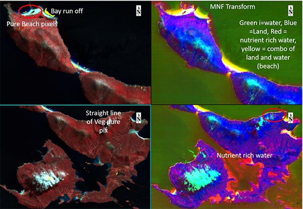
DESIS Imagery of the Falkland Islands processed with ENVI. Imagery courtesy Teledyne Brown Engineering
Spectral is a term I’ve used on a daily basis since I first started working with Landsat and AVIRIS data in 1998 at the University of Colorado. That is when I learned that a sensor in space or on a plane could tell something about the ground that I couldn’t see with my own eyes. It could tell me how dry or wet vegetation was, what kind of rock I was standing on, and what might be underneath that rock.
There were more questions than I could ever hope to answer. Those questions have only grown as sensors advanced, compute power expanded, and algorithms improved…the definition of what spectral data even means has even evolved. At one point in time, spectral data were only for experts and researchers. However, the accessibility of spectral data has widened, and with it, a new spectral revolution has begun in remote sensing.
There’s no doubt hyperspectral and multispectral instruments have been producing quality data for some time. The data are now collected more frequently, with higher spatial and spectral resolution, and better fidelity. The unlimited questions about a single point in time have become questions about changes “over time” and “across sensors.” The description of images having “n” dimensions spectrally (where n is the number of bands) becomes more expansive with the addition of a time domain (notice I didn’t say complex).
Optical remote sensing people are a scrappy bunch, they want data over their site, the source and date may not matter as much. Getting what you can when you can without those nasty clouds is step one (we can talk the miracle of SAR in another blog). Step two is prepping that data, and now step three is often combining/comparing datasets vs working with one moment in time or one sensor. The multispectral small sats currently and soon to be in orbit expands that third step, so do hyperspectral small sats, drones, and aerial options. My notion of unlimited questions of spectral data has evolved into something beyond infinite (I know, not a numeric thing) but it feels much bigger than my first concept of “a ton of possibilities.”
Sure, like any field, there’s training you need to get to what you want to know. Sure, it’s sometimes a bit of art and craft. Ignorance is usually not a good thing in life or science, but I’ve reached a point in my career where I’m comfortable in saying, “there are more things I’m ignorant about that can be done with spectral imagery that what I know can be done.” It’s an exciting place to be knowing that combining one more band or one more date in time can reveal something you didn’t think you’d see.
The doors that artificial intelligence have opened give some people pause, that all problems can be solved with algorithms and compute capacity. Adding a new computational scale like Deep Learning will let us ask even more questions and infer things we couldn’t before. And the one thing we can be sure of is change…the world will never stop changing. More people will need to be fed, habitat better preserved, and conflict will sadly always exist.
A map derived from an image is old the moment it’s published. Our climate is rapidly changing…to survive as a planet we must understand those changes and when they start/stop/accelerate/slow down. Combining sensors, dates, scale give us a different kind of understanding and the permutations, like questions, are limitless.
I never thought I’d look for penguins, marine debris, oil, grizzly bear habit indicators, fire climax fuel, track disease, study deforestation patterns, measure water quality, look for tanks, observe how vegetation changes with climate and hear friends/colleagues study coral reefs, find underpaintings from Picasso, make policy recommendations for nuclear non-proliferation, find ancient migration trails with pottery shards, forensically analyze ink and paper from serial killers, locate hidden cultures and communities, estimate population, map electricity sources and so many other applications. But now, the proliferation of data sources, software tools, computational power can make these use cases automatic and easily consumable
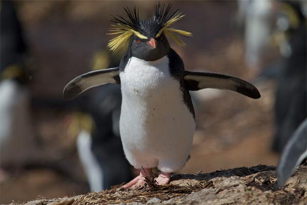
Rockhopper Penguin
NV5 Geospatial recently hosted a half day spectral thought leadership event – Spectral Sessions. Attendees learned about some of these applications from people who are experts versus a dabbler like me. If you missed this event, you can still view the recordings of all the presentations for free. You’ll see panels of experts discussing how this industry is ready to grow with spectral users who have all levels of knowledge and learn about some of the exciting sensor and software developments that will fuel these never-ending questions.
AUTOMATE ANALYTICS
Automate analytics with deep learning for fast, accurate results.
THOUGHT LEADERSHIP EVENT
Join us on January 27, 2021

RECORDED WEBINAR
See how ENVI Deep Learning is used for environmental, natural resource, and disaster response.