X

NV5 Geospatial Blog

Each month, NV5 Geospatial posts new blog content across a variety of categories. Browse our latest posts below to learn about important geospatial information or use the search bar to find a specific topic or author. Stay informed of the latest blog posts, events, and technologies by joining our email list!


Monitor, Measure & Mitigate: Integrated Solutions for Geohazard Risk

Monitor, Measure & Mitigate: Integrated Solutions for Geohazard Risk

9/8/2025

Geohazards such as slope instability, erosion, settlement, or seepage pose ongoing risks to critical infrastructure. Roads, railways, pipelines, and utility corridors are especially vulnerable to these natural and human-influenced processes, which can evolve silently until sudden failure occurs. Traditional ground surveys provide only periodic... Read More >

Geo Sessions 2025: Geospatial Vision Beyond the Map

Geo Sessions 2025: Geospatial Vision Beyond the Map

8/5/2025

Lidar, SAR, and Spectral: Geospatial Innovation on the Horizon Last year, Geo Sessions brought together over 5,300 registrants from 159 countries, with attendees representing education, government agencies, consulting, and top geospatial companies like Esri, NOAA, Airbus, Planet, and USGS. At this year's Geo Sessions, NV5 is... Read More >

Not All Supernovae Are Created Equal: Rethinking the Universe’s Measuring Tools

Not All Supernovae Are Created Equal: Rethinking the Universe’s Measuring Tools

6/3/2025

Rethinking the Reliability of Type 1a Supernovae   How do astronomers measure the universe? It all starts with distance. From gauging the size of a galaxy to calculating how fast the universe is expanding, measuring cosmic distances is essential to understanding everything in the sky. For nearby stars, astronomers use... Read More >

Using LLMs To Research Remote Sensing Software: Helpful, but Incomplete

Using LLMs To Research Remote Sensing Software: Helpful, but Incomplete

5/26/2025

Whether you’re new to remote sensing or a seasoned expert, there is no doubt that large language models (LLMs) like OpenAI’s ChatGPT or Google’s Gemini can be incredibly useful in many aspects of research. From exploring the electromagnetic spectrum to creating object detection models using the latest deep learning... Read More >

From Image to Insight: How GEOINT Automation Is Changing the Speed of Decision-Making

From Image to Insight: How GEOINT Automation Is Changing the Speed of Decision-Making

4/28/2025

When every second counts, the ability to process geospatial data rapidly and accurately isn’t just helpful, it’s critical. Geospatial Intelligence (GEOINT) has always played a pivotal role in defense, security, and disaster response. But in high-tempo operations, traditional workflows are no longer fast enough. Analysts are... Read More >

1345678910Last
«September 2025»
SunMonTueWedThuFriSat
31123456
78910111213
14151617181920
21222324252627
2829301234
567891011
11225 Rate this article:
5.0

ENVI Tasks – So easy even I get it

Anonym

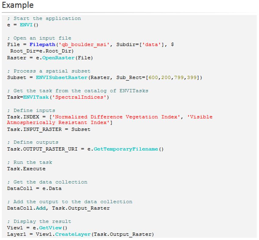
I am not a coder. I try to understand, but often find my self scratching my head. I do see the value in tasks, and understand that the sky is really the limit of what I can do with analysis on the web, or even more rapidly on the desktop. So how do I bridge the gap? ENVI Tasks. Below is a screenshot of the Task for Spectral Indices. We take the complication out of coding the process and literally define each step so there is no gray areas. It is literally copy, paste, update directories, compile, and run. Seems simple enough.

While there are over 100 tasks in ENVI+IDL currently, that is not the limit. From there, it only gets better. Add in someone who understands tasks and has a passion for what they do and so much is possible. You can take an algorithm you read in a journal flying back from a tradeshow, and now you have Landsat Built-Up Land task.

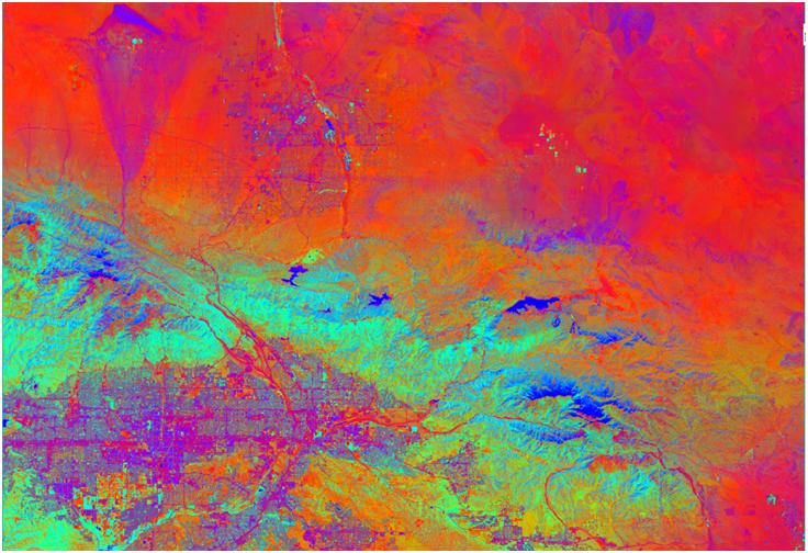
(Pic Credit JoePeters Built Up Land Task)

Now you can run an analysis with one click, or add it into a batch process, kick the script off and take on huge datasets while you are away over the weekend. Take it one step further and deploy these simple task in a web instance and now you can have users in the field running NDVI on a tablet while they are standing in the actual field.

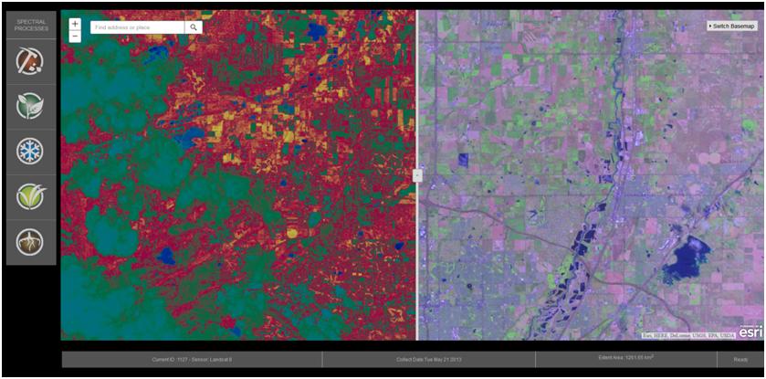
(Pic Credit Beau Legeer’s ESE Spectral Indices Web App)

ENVI Tasks are literally that easy and the possibilities are truly endless of how you can grow and deploy your analysis.

ENVI Tasks, I get them. 

Please login or register to post comments.