Save Time and Effort by Organizing Your Data with Jagwire
Anonym
Entry 1 in Blog Series: Getting to Know Jagwire
Performing detailed Geospatial Analysis is a complex and time consuming activity. Applicable data can vary greatly in size and complexity, from Multi-Spectral Satellite imagery covering many spectral bands and weighing in at up to gigabytes per image, to High Definition video collections covering hours of flight time, to compact vector and feature based data, small in size, but powerful in content.
For the scientist or analyst, organizing these vast collections of data can quickly become a time consuming and unrewarding chore. Jagwire provides a central repository for all of your Geospatial Data, storing and organizing the data, thus removing this burden from the user Once equipped with Jagwire, users are able to formulate coherent questions and queries about their data, such as:
- Do I have any LiDAR or Digital Elevation Model(DEM) coverage of this area?
- Do I have any images that cover this area before and after a significant event took place?
- Find me all the vector data that occurs within the footprint of this image.
- Find me IR band video covering this location between the hours of 4 and 5 pm.
The ability to ask these sorts of questions about a datastore serves to jumpstart the work of the scientist or analyst, allowing them to skip over painful data organization tasks and move directly to the more important work that demands their time and focus.
Jagwire offers several differentiating features as a data archive system. One powerful feature is the ability to Federate searches between different Jagwire nodes. If you have different Jagwire nodes set up at different sites, a single search can look across all connected archives, giving the users a seamless way to share their data stores.
Further, Jagwire offers considerably enhanced search precision according to temporal and spatial criteria. Consider the following case, wherein the data product is a full motion video collection, which moves in and out of the desired query area over time.
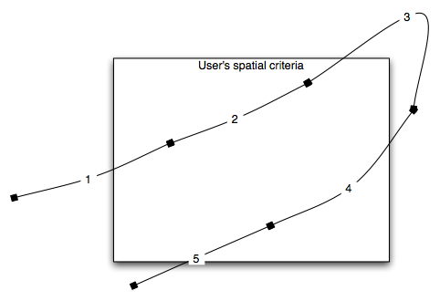
Most video archive systems would segment the incoming video stream into several clips of a given duration (segments 1 through 5 above). Then, when a spatial query is issued, the system would return the entirety of clips 1 through 5, as each clip has some segment that falls within the given spatial criteria.
Jagwire’s more precise spatial search criteria would provide the user with exactly and only that data which matches their request. The response would come as two consolidated clips, the first clip beginning approximately halfway through clip 1 and ending a quarter of the way into clip 3. The second would begin partway through clip 4 and end through clip 5. In this way, Jagwire provides the user with a set of consistent video streams, and limits the data returned to exactly and only what the user requested.
Entry 2 in Blog Series: Disseminate your Geospatial Data with Jagwire >