Upgrading the GMTED2010 global elevation data included with ENVI
Anonym
The Global Multi-resolution Terrain Elevation Data 2010 (GMTED2010) dataset is the elevation dataset of choice for global and continental scale applications. GMTED2010 is the result of a joint development effort between the U.S. Geological Survey (USGS) and the National Geospatial-Intelligence Agency (NGA). GMTED2010 is a major improvement in consistency and vertical accuracy over GTOPO30.
Starting with version 5.1, the ENVI software installation includes the GMTED2010 dataset for the mean elevation aggregation method at 30 arc-seconds spatial resolution in numerically lossless JPEG2000 format. ENVI provides the GMTED2010 dataset as a convenience for users who need a digital elevation model in their data visualization or image processing workflows. The GMTED2010 dataset can be easily opened in the ENVI software using the "File > Open World Data > Elevation (GMTED2010)" menu option and certain processing tools such as the RPC Orthorectification and Image Registration workflows will automatically use this dataset as the default DEM.
Within the ENVI software installation the GMTED2010 dataset is distributed as a file named "GMTED2010.jp2" that is 152 MB in size and the default path locations are as follows:
Windows: C:\Program Files\Exelis\ENVIxx\data\GMTED2010.jp2
Linux: /usr/local/exelis/ENVIxx/data/GMTED2010.jp2
Macintosh: /Applications/Exelis/ENVIxx/data/GMTED2010.jp2
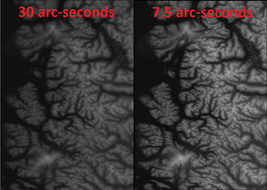
In the next few weeks an alternate version of the GMTED2010 dataset with 7.5 arc-seconds pixel size will be provided on the Downloads section of the Exelis VIS website (user account required). This upgraded "GMTED2010.jp2" file is 1.54 GB in size and provides a higher spatial resolution global elevation model which can improve the accuracy of RPC Orthorectification and automatic tie-point generation in Image Registration (if at least one input image has RPC metadata).
To replace the GMTED2010 dataset in the ENVI software installation with this higher spatial resolution 7.5 arc-seconds version simply overwrite the "GMTED2010.jp2" file in the appropriate path based on computing platform listed above (may require administrative privileges). Here is a screenshot of the 30 arc-seconds dataset distributed as part of the ENVI software installation (left) and the upgraded 7.5 arc-seconds version (right) that you will soon be able to download from our website:

Credit: GMTED2010 dataset provided courtesy of USGS
Reference: Danielson, J.J., and Gesch, D.B., 2011, Global multi-resolution terrain elevation data 2010 (GMTED2010): U.S. Geological Survey Open-File Report 2011–1073, 26 p., https://pubs.usgs.gov/of/2011/1073/pdf/of2011-1073.pdf