X

NV5 Geospatial Blog

Each month, NV5 Geospatial posts new blog content across a variety of categories. Browse our latest posts below to learn about important geospatial information or use the search bar to find a specific topic or author. Stay informed of the latest blog posts, events, and technologies by joining our email list!


Deploy, Share, Repeat: AI Meets the Analytics Repository

Deploy, Share, Repeat: AI Meets the Analytics Repository

10/13/2025

The upcoming release of ENVI® Deep Learning 4.0 makes it easier than ever to import, deploy, and share AI models, including industry-standard ONNX models, using the integrated Analytics Repository. Whether you're building deep learning models in PyTorch, TensorFlow, or using ENVI’s native model creation tools, ENVI... Read More >

Blazing a trail: SaraniaSat-led Team Shapes the Future of Space-Based Analytics

Blazing a trail: SaraniaSat-led Team Shapes the Future of Space-Based Analytics

10/13/2025

On July 24, 2025, a unique international partnership of SaraniaSat, NV5 Geospatial Software, BruhnBruhn Innovation (BBI), Netnod, and Hewlett Packard Enterprise (HPE) achieved something unprecedented: a true demonstration of cloud-native computing onboard the International Space Station (ISS) (Fig. 1). Figure 1. Hewlett... Read More >

NV5 at ESA’s Living Planet Symposium 2025

NV5 at ESA’s Living Planet Symposium 2025

9/16/2025

We recently presented three cutting-edge research posters at the ESA Living Planet Symposium 2025 in Vienna, showcasing how NV5 technology and the ENVI® Ecosystem support innovation across ocean monitoring, mineral exploration, and disaster management. Explore each topic below and access the full posters to learn... Read More >

Monitor, Measure & Mitigate: Integrated Solutions for Geohazard Risk

Monitor, Measure & Mitigate: Integrated Solutions for Geohazard Risk

9/8/2025

Geohazards such as slope instability, erosion, settlement, or seepage pose ongoing risks to critical infrastructure. Roads, railways, pipelines, and utility corridors are especially vulnerable to these natural and human-influenced processes, which can evolve silently until sudden failure occurs. Traditional ground surveys provide only periodic... Read More >

Geo Sessions 2025: Geospatial Vision Beyond the Map

Geo Sessions 2025: Geospatial Vision Beyond the Map

8/5/2025

Lidar, SAR, and Spectral: Geospatial Innovation on the Horizon Last year, Geo Sessions brought together over 5,300 registrants from 159 countries, with attendees representing education, government agencies, consulting, and top geospatial companies like Esri, NOAA, Airbus, Planet, and USGS. At this year's Geo Sessions, NV5 is... Read More >

1345678910Last
«October 2025»
SunMonTueWedThuFriSat
2829301234
567891011
12131415161718
19202122232425
2627282930311
2345678
13942 Rate this article:
5.0

Use ENVI and DigitalGlobe Data to Help Recovery Efforts in Nepal

Anonym


This past week, NV5 (formerly Exelis) and Maxar (formerly DigitalGlobe) agreed to provide a new commercial offering of cloud-based ENVI analytics for the DigitalGlobe Geospatial Big Data Platform (GBD). The agreement will enable imagery users to easily combine powerful geospatial analytics with the vast DigitalGlobe image library to solve challenging environmental, natural resource and global security problems.

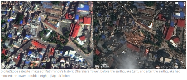
In response to the devastating 7.8 magnitude earthquake that struck central Nepal on April 25, DigitalGlobe has made high resolution satellite imagery of the affected areas freely available online to all groups involved in the response and recovery effort. This imagery can be accessed via https://services.digitalglobe.com/myDigitalGlobe/login. For more information on how to access DigitalGlobe high resolution imagery to aid in recovery efforts, see this blog post.

In addition to the offerings that DigitalGlobe has made available, DigitalGlobe and Exelis have put their new partnership to good use by setting up Amazon instances allowing free access to the data and ENVI image analysis software for anyone that would like to lend their image analysis skills to generate useful products for response and recovery efforts. If you are interested, contact us at geospatialinfo@nv5.com.

Please login or register to post comments.