X
3544 Rate this article:
4.6

ENVI Inform in Action: Deforestation Monitoring in Chile

Nate Oscar

Problem:

Illegal logging is a major concern in many parts of the world. In Chile, it causes significant environmental damage and economic losses of up to $70 million a year.

To help tackle illegal logging, timber companies need a way to monitor forest conditions and identify areas that have unusual or suspicious activity that may require intervention. The challenges they face include large areas that need to be monitored, the need for frequent updates, the prohibitive expense of using aircraft or drones for gathering data, and adverse weather conditions that often delay missions.

Sentinel 2 SAR Data

Sentinel 2 imagery of Chile.

Solution:

A company that has a centralized and artificial intelligence-based platform that provides real-time and near real-time disaster and risk intelligence services, partnered with NV5 Geospatial to develop an automated service that processes satellite data for entire regions and countries to deliver actionable deforestation information to timber companies and other organizations.

ENVI Inform helps monitor wide areas

ENVI Inform automatically monitors wide areas by processing and analyzing large volumes of data, extracting actionable information, and publishing the results to the customer's platform.

When developing the solution, the first thing that needed to be determined was which satellite data source to use. Given the requirement for a frequent revisit rate, availability of historical data, and low cost, data from the European Space Agency’s (ESA) Copernicus programme was chosen. Specifically, a solution based on multispectral data from Sentinel-2 and Synthetic Aperture Radar (SAR) data from Sentinel-1 was selected. Utilizing SAR meant data could be collected at night and in cloudy conditions. Combining this with multispectral data provided an increased revisit rate.

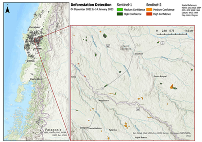
Using archives hosted by ESA, the Alaska Satellite Facility and Amazon, NV5 Geospatial hosted industry-leading ENVI® and ENVI SARscape® analytics on ENVI Inform to create an historical baseline that identified changes in forested areas. As new multispectral and SAR satellite data is collected and made available, ENVI Inform automatically retrieves the data and processes it, generating fully updated results within hours of acquisition. The processing results are appended to previous outputs to identify temporal changes compared to the historical baseline. Updates are published to the customer’s platform which combines them with additional data sources providing users with an on-demand, event-centric solution.

Results:

Utilizing ENVI Inform, the customer successfully created an automated monitoring service to identify deforestation activities across Chile. The benefits of ENVI Inform are that once an area of interest (AOI) is identified, information can be updated in near-real time and published to the customer’s platform, which enables forestry analysts to compare the results with other data sources and make better-informed and more timely decisions.

Contact us to learn more about ENVI Inform and find out how an automated monitoring service can help your mission.


DISCOVER MORE

Students, Researchers and Instructors

ACADEMIC SOLUTIONS

Using ENVI and IDL for research and to prepare students for successful careers.

SCIENTIFICALLY PROVEN, EASY TO USE

ENVI Software

ENVI SOFTWARE

Extract meaningful information from all types of geospatial imagery and data.

INTERACTIVE DATA LANGUAGE

IDL SOFTWARE

Extract meaningful visulizations from complex numerical data.