Effective Wildfire Management Using Remote Sensing Technology
Author: Amanda O'Connor , NV5
Fire is a naturally occurring phenomenon and is a vital part of ecosystem succession. Due to decades of fire suppression, many forests are in an overgrown state which contributes to the massive fires we’ve seen in recent years. “Fire season” in many parts of the world now lasts the entire year versus just a few months.
In addition to fire suppression, a convergence of factors including population spread into the wildland urban interface (WUI), climate trends that are creating drier and hotter conditions, and a lack of mitigation on federal, public and private lands have created a perfect storm for mega fires to form and spread. Understanding the risks and combatting and recovering from wildfires is a complex undertaking. Remote sensing can aid in all aspects of fire management – mitigation, prevention, managing active incidents and recovery.
Mitigation: Applications and Benefits of Remote Sensing for Wildfires
Fire mitigation can take on many forms from homeowners performing mitigating efforts on their property (removing brush, ladder fuels), to fire preparation on public lands (thinning, creating fire breaks), as well as numerous other physical and social changes (e.g. fire bans, public education etc.). While physical mitigation is never 100 percent effective, pre-fire danger can be monitored and predicted using remote sensing to assess fuel moisture, density, fuel types and topography.
Hyperspectral data can identify fuel types, fuel moisture and density, and map invasive plant species which can be more combustible than native species. Synthetic Aperture Radar (SAR) and multispectral data can also provide some of these measurements depending on the sensor. Risk maps can be created by combining other information like topography, wind, weather patterns, location of infrastructure, etc. LiDAR data can be used to understand vegetation encroachment near critical infrastructure that can potentially cause fires or be damaged in a fire.
Remote sensing can play an enormous role in the mitigation phase for preventing and planning for wildfires. While some aspects require more advanced remote sensing skills, many can be performed with the guided tools that come in ENVI software, like change detection, vegetation health, deep learning to map manmade structures and more.
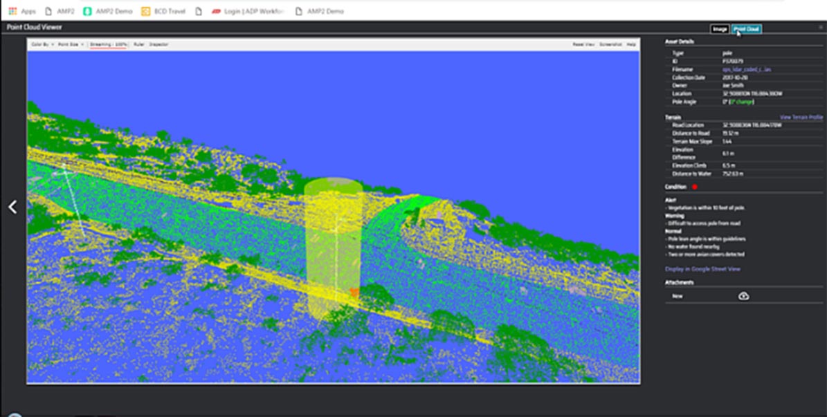
LiDAR can be used to understand encroachment around utility infrastructure. Above, you can see the automatic detection of vegetation encroachment on a utility conductor and pole with a specific area of encroachment identified (10’).
Prevention: Applications and Benefits of Remote Sensing for Wildfires
Fire prevention as well as rapid detection soon after a fire starts is a critical component to fighting fires. Currently most fires in populated areas are detected by human sightings either via smoke or aerial surveys. Satellite imagery can be used to detect fires in remote areas such as with weather satellites like GOES or moderate resolution imagery like NPP-VIIRS.
NV5 has a long history of using deep learning to solve complex problems. Using training data from the High-Performance Wireless Research and Education Network (HPWREN), this technology can be used to automatically detect smoke columns. NV5 is developing an operational system to automatically detect smoke without the need for humans in the loop using our existing Helios camera network and models of smoke. These kinds of investments take technology, infrastructure and collaboration with public and private organizations as well as the time to create reliable models.
Data source: HPWREN, University of California San Diego partnership project led by the San Diego Supercomputer Center and the Scripps Institution of Oceanography's Institute of Geophysics and Planetary Physics.
In addition to plume detection, plume thickness can also be assessed. This information can support air and ground resources as well as provide insights on local weather and atmospheric interactions.
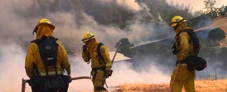
Response: Applications and the Benefits of Remote Sensing for Wildfires
There are many ways remote sensing can be used during an active fire. One way is mapping fire perimeters with thermal imagery. Thermal imagery can penetrate large smoke plumes and be flown continuously during a fire to frequently update the location of fire lines. NV5 Geospatial's Jagwire product can be used to catalog imagery collected during a fire as well as ancillary imagery and other information about a fire. Jagwire allows boundaries between federal, state, city/county and volunteer fire organizations to be dissolved so each can see the same holdings and data can be streamed to Android Team Awareness Kits (ATAK) and handheld devices for firefighters in the field. This common access is especially vital on Type 1 Federal Incidents when all levels of firefighters would be involved.
Jagwire for Fire Fighting Operations
Main use – Near real-time (NRT) data ingest and dissemination of commercial full motion video (FMV) with thermal detections
Jagwire provides visualization and NRT streaming out to 3rd party applications
Range and Bearing Environmental Resource Mapping Corporation (RAB) has worked with NV5 for many years to make thermal infrared data available to first responders and decision makers as quickly as possible. NV5 helped RAB to develop and refine an accelerated ortho-rectification and machine vision analytics process using NVIDIA Graphics Processing Units (GPU). It has achieved huge leaps in forward-edge parallel processing, creating seamless broad-area thermal infrared imagery and shared heat intensity geospatial intelligence as fast as the images are collected above the fire.
RAB is a technology innovation company in Victoria, B.C. Canada with extensive experience owning and operating airborne intelligence, surveillance and reconnaissance (ISR) platforms, spending many tens of thousands of hours focused on wildfire intelligence development and operations in Canada and the U.S. RAB's current SPOTHAWK technology offers advanced, software-defined, human-commanded, machine-controlled, real-time remote sensing capability for ISR platforms with existing FMV imaging systems.
The evolving SPOTHAWK technology assures that every platform operator will have equal opportunity to create better, more frequent, rapid wildfire intelligence from lower cost platforms without the requirement for specialized mapping camera payloads or manual infrared interpretation.
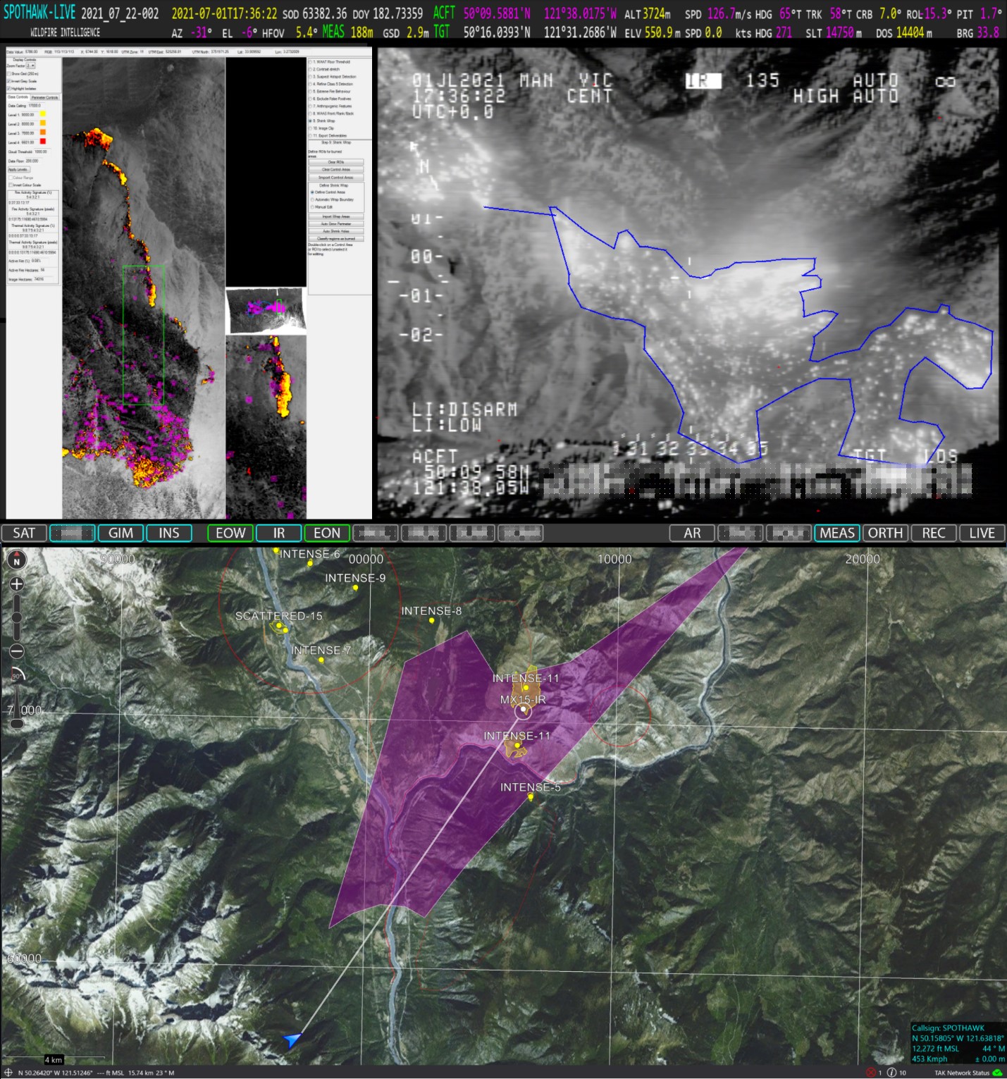
FMV is autonomously transformed on the fly via ortho-rectification and machine vision analytics capturing heat intensity and the fire perimeter at scale. Live telemetry of firefighting intelligence streams to Team Awareness Kit (TAK) situational awareness networks that already host firefighting crews and resource positions, providing long-anticipated firefighter safety-of-life benefits. EOIR image courtesy of Transport Canada.
During an active fire, remote sensing can be used to identify safety zones where threatened fire crews can find adequate refuge from an approaching fire. In October 2020, the Calwood Fire in Boulder County, Colorado burned over ten thousand acres and destroyed 26 structures. Dry and windy conditions caused the fire to grow quickly, spreading nearly 1,000 acres per hour. This led to early evacuations in several nearby communities and put areas of Boulder and Longmont on alert.
LiDAR can be used to measure tree height, location and canopy as well as topography and other parameters to help create safe zone maps. This kind of tool is useful in preparation for fires or in large scale fires where there’s information on where the fire may run. The combination and automation of creating these types of safe zone maps is a key strength of ENVI and its enterprise capabilities as other ways of combining diverse datasets can be time consuming in situations where time is of the essence.
How to Compute a Safety Zone
Inputs for Creating Safety Zone
Calwood Fire Safety Zones (October 18, 2020)
Recovery: Applications and Benefits of Remote Sensing for Wildfires
Once a fire has ended, there are often risks created by the dramatically changed landscape. With the destruction of vegetation that holds soil in place, there is an increased risk of flash floods and landslides.These risks can be assessed using normalized difference burn indices to understand where the fire was most severe and when combined with topographic information like slope and aspect, areas most at risk for these conditions can be identified. ENVI has tools to create and layer this information using optical and SAR data to generate a heat map of landslide and flash flood risks.
The U.S. Geological Survey (USGS) and California Department of Forestry and Fire Protection (CAL FIRE) produced a soil severity burn map of the November 2018 Camp Fire, which was the deadliest and most destructive wildfire in California's history. This map correlates with high intensity burn areas. Using this information, the Sentinel-1 SAR sensor was trained on severely burned areas which corresponded to higher intensity returns.
There were seven Sentinel-1 scenes collected from October 30 through November 29, 2018. Both vertical transmit and horizontal receive (VH) and vertical transmit and vertical receive (VV) were used to pick out different characteristics, though VH proved most useful for this example. Camp Fire shapefiles and report are courtesy of CAL FIRE.
Above left is threshold training. Above right shows the most intense burn zones extracted, with DEMs or SAR derived DEMs, showing slopes with a high potential for erosion.
Following a fire, many homeowners and businesses are faced with the very hard decision of whether or not to rebuild. Some factors that come into this process are the safety of assessing a site. For example, many trees may have burned in an area but not fallen and are at risk for doing so. Optical imagery and LiDAR can help understand where there are still standing trees and fire information can be used to analyze how severe the fire was in a certain area.
This kind of information can also support decisions to erect barriers around watersheds so that soot does not wash into hydrographic areas and cause damage to aquatic ecosystems and food chains. Severe burns can effectively sterilize the soil making it difficult for vegetation to regrow, but with imagery and SAR data you can assess the regrowth rate and better predict the rate of recovery. Some fires can be so hot that tree roots can continue burning even if a fire is totally contained and thermal imagery can help identify these areas. In these cases, the fire may be 100% contained, but not out until significant snow or rain.
Conclusion
While remote sensing integration into all levels of fire management can be daunting, NV5 Geospatial and organizations involved in remote sensing like Range and Bearing are here to help – whether it's as simple as pointing you in the right direction for software documentation, or as multifaceted as assessing what's required to complete a project within your time frame and budget.
With wildfires increasing in severity and frequency and with more people living in areas prone to them, the stakes have never been higher for effective management. While the process of predicting, fighting and recovering from wildfires is complex, NV5 Geospatial has solutions that are successfully deployed at all stages of wildfire management. If you are interested in discussing how these solutions can help your organization, please contact us.
Download a pdf of this whitepaper.
AUTOMATE ANALYTICS
Automate analytics with deep learning for fast, accurate results.
SOLUTIONS eBOOK
Enhance preparation and response with remote sensing technologies.
WEBINAR
See how to effectively use geospatial data in the disaster management cycle.