Earth Observation to Mitigate Impacts of Climate Change and Support Sustainable Business Decisions
Author: Nicolai Holzer, NV5
Abstract
Environmental, Social and Corporate Governance (ESG) criteria are a set of standards for a company’s operations that can serve as a corporate “scorecard” to measure a businesses’ sustainability and societal impacts. Remotely sensed Earth observation is key to monitor environmental criteria (the “E” in ESG) including identifying sources of air or water pollution, and measuring progress towards sustainability goals including approaches on climate action and the preservation of natural habitat and biodiversity.
COP26 made it clear – Things need to change
The 2021 United Nations Climate Change Conference (also known as COP26) that was held in Glasgow, Scotland, made it clear that our planet is under increasing pressure, and things need to change. The over-riding theme of the conference was that the planet has entered a critical time of global crises and transformational change and solving our climate crisis is arguably the most pressing problem of our time. Therefore, it is imperative to not only manage and mitigate the risks that climate change poses, it is of equal importance to identify potential opportunities to increase sustainable practices and develop a posture of resilience.
At COP26, major initiatives and plans were discussed to reduce emissions, end deforestation and protect our oceans. On the business side of the equation, organizations are waking up to the realization that sustainable practices with innovative solutions are needed to ensure the long-term creation of wealth and prosperity. The emerging business bottom line: Sustainable prosperity requires meeting the needs of the present, without compromising the future.
What is ESG and why businesses should care about sustainability?
To optimize sustainability in business operations, integrated strategies can be linked to economic performance, social responsibility and environmental management. Adoption of these strategic practices leads to operating under ESG criteria. Since ESG criteria are used to evaluate socially responsible investments, compliance is of critical importance to avoid ESG related risks and a maintain a continued stream of investment capital.
But it isn’t just financial institutions and socially responsible investors that are looking to finance companies that place environmental sustainability on at least equal footing with profits. Investors and consumers across the board are becoming increasingly concerned about the downstream consequences of their investing and buying decisions. Customers want to feel good about what they purchase and want to see the companies they buy from make a positive difference in the world. As consumer and investor pressure increases, ESG criteria will continue to grow in importance for driving investment and purchase decisions, which in turn will elevate the importance of the accurate monitoring and measuring of ESG related practices.
The value of Earth observation for businesses
The availability of Earth observation data and the applications that leverage it have grown exponentially in recent years. As the quality and revisit rates of satellite data has risen, there have also been advances in big data and machine learning that have enabled the extraction of insights and answers that were not possible before. This has prompted businesses to add geospatial data and analytics to their decision-making processes, an addition that has proven to be invaluable, particularly when it comes to physical, location-specific assets.
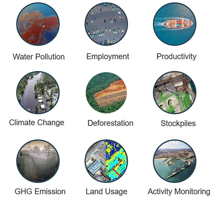
Fig. 1: Examples where Earth observation can provide business intelligence insights in support of sustainability and commodity types of investments.
Periodic satellite-based monitoring of industrial locations can reveal insights that allow for estimates on commodity types of goods and investments concerning sustainability. This information helps answer business intelligence questions such as industrial land usage (size of an asset, construction, demolition); employment data (counting cars at plants and stores); raw material stockpiles (containers, crude oil tanks etc.); product inventory (manufactured cars, etc.); and much more.
In terms of sustainability, the real-world information revealed by Earth observation data provides investors with quantitative, measurable ESG indices. For example, it can be determined how businesses and industries are managing their carbon emissions, how they are impacting (or polluting) the environment, and what their greenhouse gas (GHG) emission levels are?
Satellite data reveals insights based on observed data and not on proxies by estimates or reporting. And, if you can measure it, you can manage it – Earth observation can deliver hard numbers that can be measured and compared over time. This powerful source of incontrovertible evidence goes beyond what a company may report on its own accord. Earth observation will influence what is disclosed so sustainability reports avoid “greenwashing”.
Example 1: Earth observation helps businesses curb GHG emissions
To tackle the pollution problem, Earth observation technology can support businesses to improve ESG performance. This is accomplished with monitoring to help reduce emissions, to better understand carbon sources, to pinpoint super-emitters so repairs can be made, and to ensure carbon reduction commitments are meet. Carbon dioxide (C02) is the most common climate-warming gas, accounting for nearly 80% of all greenhouse gas emissions. C02 is followed by Methane gas as the next most common climate-warming gas, and while it accounts for lower emissions, it is exponentially more potent in warming up the Earth's atmosphere.
Greenhouse gases such as methane (CH4) and CO2 absorb electromagnetic radiation in many parts of the infrared spectrum, which can be measured with hyperspectral sensors. Satellite data can reveal and verify evidence of greenhouse gas hotspots such as increased levels of nitrogen dioxide (a major pollutant associated with industrial activity).
Along with satellite data, wind speed and direction can connect a pollution cloud to a site or specific facility. This type of monitoring can determine in near-real time the source of atmospheric or water pollution. The following are examples of how remote sensing can monitor GHG emissions to help meet climate change mitigation targets:
-
AVIRIS-C and AVIRIS-NG are hyperspectral airborne sensors (JPL /NASA) that detect and measure methane and carbon dioxide emission plumes (Figure 2).
-
The upcoming hyperspectral satellite constellation Carbon Mapper (Planet/NASA) will help accelerate the mitigation of methane super-emitters, independently verify power plant CO2 emissions globally, and deliver 25+ other hyperspectral indicators for carbon and ecosystem management (at about 30m pixel resolution) (Figure 3).
-
GHGSat is building its own satellite constellation to monitor greenhouse gases in high-resolution, providing emission data and intelligence to businesses, governments, regulators and investors worldwide.
-
Orbital Sidekick is establishing a space-based infrastructure of hyperspectral sensors that will be able to monitor environmental pollution.
-
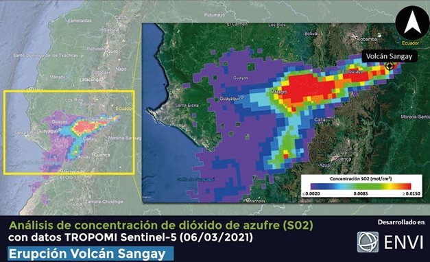
As announced at COP26 by the European Space Agency (ESA) and the European Union's Earth-monitoring program Copernicus, a new space mission is currently being developed by ESA and the European Organization for the Exploitation of Meteorological Satellites (EUMETSAT). Once operational (expected 2026), the satellites of this mission, called European CO2 Monitoring and Verification Support Capacity (CO2MVS) on anthropogenic emissions, will be able to measure concentrations of the two most common greenhouse gases (carbon dioxide and methane). Currently the satellite Sentinel-5P of the European Union Copernicus mission can provide valuable information on greenhouse gas emissions, though at much poorer resolutions (Figure 4).
Example 2: How Earth observation can help business identify climate change impacts
Earth observation has become a key instrument for organizations to study how climate and environmental changes are likely to affect industries and markets worldwide. Companies are finding it difficult to identify exposure and quantify risks of their physical assets due to changing climate conditions such as natural disasters and other extreme climatic events. If affected, climate disasters directly impact the fiscal performance of a company. Therefore, accurate measures are needed to help manage and price their climate related risk exposure based on various scenarios. This in turn enables financial institutions that are investing in these companies to quantify the climate risk factors in their portfolio. Earth observation can help to estimate the expected impact of climatic change and a potential disaster’s impact on physical assets of a company (infrastructure) as well as their markets (agriculture).
Fig. 4: Example of using Sentinel-5P data in ENVI® to map Sulfur dioxide (SO2) pollution as result of the 2021 eruption of volcano Sangay in Ecuador. Source: Geospace Solutions, Ecuador (www.geospace-solutions.com/)
Example 3: Earth observation to monitor deforestation and support certification programs
Another example where earth observation can help support more sustainable business practices is in controlling standards for sustainability certification programs. There are more and more certification programs in place for practices such as fair-trade and organic food. Particularly for those that are certifying forestry and agricultural products including timber, palm oil, coffee, cocoa or tea, Earth observation can help in supporting and verifying that environmentally appropriate, socially beneficial, and economically viable sustainability standards are met.
Deforestation, largely driven by economic pressure, is one of the largest sources of greenhouse gas emissions. Synthetic Aperture Radar (SAR) satellite sensors can monitor land cover even under cloudy conditions and without the sun’s light, making it an important technology for monitoring boreal and tropical regions.
In Brazil for example, most illegal cutting occurs in the rainy season as the cloud cover makes it nearly impossible for optical imagery to consistently monitor areas. SAR based Earth observation can be used to map, monitor, measure, and analyze remote and large forested areas, not only to identify and track deforestation, but also to ensure responsible land use and to control sustainability standards for certification programs.
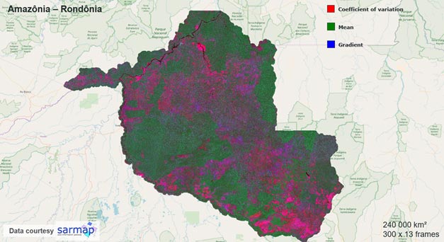
Fig. 5: Temporal descriptors derived from statistical Sentinel-1 SAR time series processing with ENVI SARscape® in Amazonia, Brazil: Deforestation is obvious when there are sudden changes in the SAR backscatter over time (which is particularly sensitive to forest biomass), here highlighted in purple. Source: sarmap s.a. (https://www.sarmap.ch)
To sum it up: Earth observation is a powerful tool to support sustainable business decisions
These examples show that sustainability not only has a positive impact on solving our most pressing global problems and strengthening resilience, but sustainability is also good for business. Adopting sustainable practices through innovative solutions, including design, planning and technology, creates long-term value and wealth. The business case for sustainability is made through the mitigation of climate change related risks and compliance with ESG criteria (particularly the “E”), that increasingly are driving investment decisions, impacted by economic, social and environmental global pressures.
Earth observation is a key instrument to help organizations in their analysis and management of sustainability related risks, to adopt more sustainable practices, promote development goals, measure and verify reported commitments, and demonstrate positive impacts for investors, customers and the public. Combining Earth observation data with other sources such as reports, analytics, and social media can help facilitate more transparent and timely decision making. This includes approaches for climate action and the preservation of natural habitats and biodiversity, and to track and report on targets and hold individuals, businesses and governments accountable.
Looking toward the future
Earth observation can provide detailed metrics particularly on environmental related risk exposures to measure ESG criteria status and progress. Earth observation also plays a unique role in supporting the assessment of national and international sustainability programs such as the European Commission's Green Deal policy initiative to shape a zero-carbon economy, the Next Generation EU recovery fund that focuses on a digital transition and tackling climate change impacts, and the Sustainable Development Goals (SDGs) set by the United Nations. This is the world’s shared plan to end extreme poverty, reduce inequality, and protect the planet by 2030 – creating an inclusive, sustainable and resilient future for everyone.
What does the future hold for the Earth observation industry itself? Sustainability has the potential to act as long-term driver for investments in Earth observation data and technology, across all type of industries. This investment provides the industry the opportunity to do good in the world, help build an enduring and sustainable future and leave the world a better place tomorrow than it is today!
If you are interested in using remotely sensing data to help mitigate climate change impacts or support sustainable business development, NV5 Geospatial has the solutions and expertise to help. The remote sensing analysis software, ENVI, is trusted across industries to extract meaningful information from all types of data, while ENVI SARscape, created by NV5 Geospatial and sarmap SA, has tools to process and analyze SAR data. Reach out to one of our experts today to get started achieving your goals.
AUTOMATE ANALYTICS
Automate analytics with deep learning for fast, accurate results.

SOLUTIONS eBOOK
Enhance preparation and response with remote sensing technologies.

WEBINAR
See how to effectively use geospatial data in the disaster management cycle.