Disaster Strikes Again, This Time In Our Backyard
Amanda O'Connor
December 30, 2021 was an official workday for NV5 Geospatial. Many of my co-workers took a vacation day to extend their holiday breaks. I, myself, was working and pondered creating a “year-end highlights” blog that would review the previous 12 months.
The past year has been one for the books in terms of natural disasters. We’ve been devoting a lot of time to thinking about how remote sensing and particularly our software and solutions can help with planning for and predicting disasters, as well as aiding during and after they hit. One of our office buildings is located on the front range of Colorado’s Rocky Mountains, so those of us that live here are ever mindful of wildfires. But we’ve relegated our real concern to those who live in the foothills and mountains, where Colorado wildfires typically occur. Last week all of that changed.
The Marshall Fire in Boulder County, Colorado, started as a small fire several miles to the northwest of our Broomfield office just after 11 a.m. on the 30th. Winds that gusted above 100 mph quickly pushed the fire eastward, and within 30 to 45 minutes, homes were already in jeopardy and the unfolding disaster was forcing residents to flee, many with just the clothes on their backs. The fire’s path stayed north of our offices, but several of our coworkers’ homes were affected.
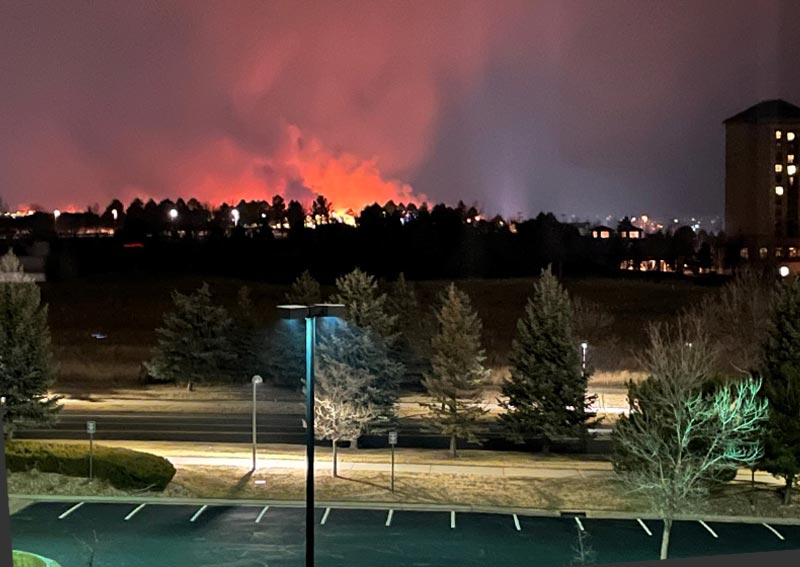
Picture of the Marshall Fire taken from the NV5 Geospatial office building in Broomfield, Colorado on the evening of December 30, 2021.
The cause of the fire remains under investigation, but what isn’t up for debate is that many parts of Colorado had their warmest Fall on record, and with only around an inch and a half of moisture over the last seven months, the Denver metro area was primed for the unthinkable to happen. Two people lost their lives in the fire that consumed over 6,000 acres and destroyed more than 1,000 homes and businesses. It also left us all, wherever we reside, with the uneasy feeling that places previously considered “safe” from climate-related disasters are not nearly as immune as we thought.
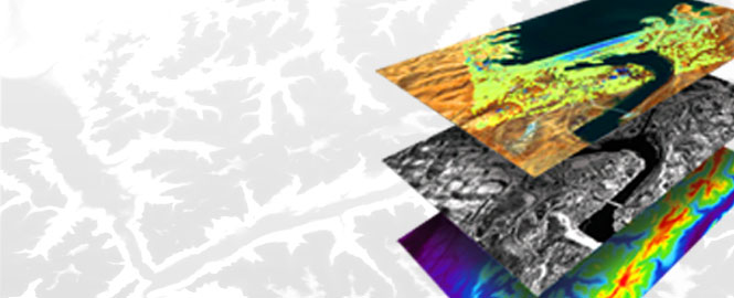
Left image : A coherence change detection algorithm in ENVI® SARscape was run over the area of the Marshall fire using 15m^2 resolution Sentinel-1 SAR data. The data was collected over the region on December 7, 19 and 31. The area in red shows a major loss of coherence (similarity between the processed data/scenes), caused by the spread of the fire (indicating a major change between them).
SAR THREE-PART SERIES
Learn Synthetic Aperture Radar (SAR) applications and benefits.

SAR WEBINAR
Surface Motion Monitoring Using SAR Interferometric Techniques
RECORDED WEBINAR
Effectively Use Geospatial Data in the Disaster Management Cycle