X
5640 Rate this article:
4.0

NovaSAR-1 is Almost Here – Enhancing Remote Sensing Applications

Anonym

Synthetic Aperture Radar (SAR) is rapidly becoming a fundamental and critical dataset in geospatial analysis. Unlike many other observational methods, SAR is not limited by illumination or cloud cover, so collection and subsequent analysis can be conducted night or day, and even in inclement weather.

One of the most recent and exciting new SAR instruments is NovaSAR-1, which is a small Synthetic Aperture Radar (SAR) mission. It has been partly funded by the UK Government and its mission partners include the UK Space Agency, Australia’s Commonwealth Scientific and Industrial Research Organisation (CSIRO), the Indian Space Research Organisation (ISRO), the Republic of the Philippines Department of Science and Technology-Advanced Science and Technology Institute (DOST-ASTI), and Space-Eyes LLC.


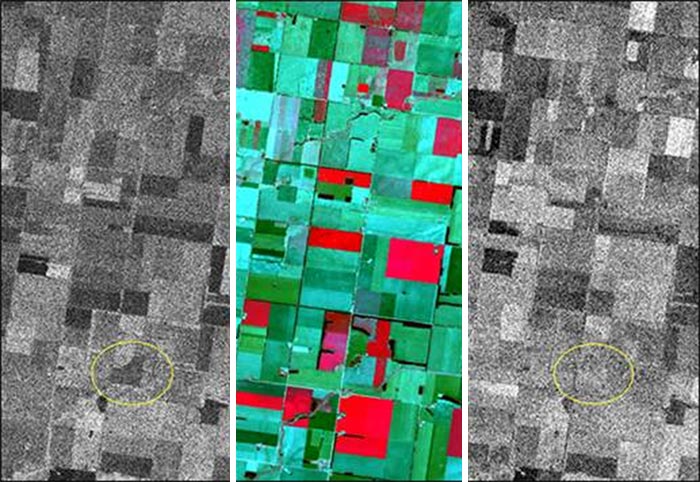
Images were captured of the same location by NovaSAR-1, Sentinel-1, and Sentinel-2. (Left) NovaSAR-1 HH acquired June 20; (Middle) Sentinel-2 June 21; (Right) Sentinel-1 June 15.

NovaSAR-1 was launched in 2018 and is close to being operational. The S-band SAR platform provides medium resolution (6 - 30m) data, which is ideal for applications in the following fields:

  • flood monitoring
  • agricultural crop assessment
  • forest monitoring (temperate and rain forest)
  • land-use mapping
  • disaster management
  • maritime applications

Data from Sentinel-1 and 2 and NovaSAR-1 complement each other well. In the image highlighted to the left, one can see the way that the way NovaSAR-1 C-band and Sentinel-1 S-band interact with ground cover can be quite different for an identical agricultural area.

ENVI® SARscape® and ENVI SARscape Analytics can be used to easily process and analyze just about all SAR data like that from NovaSAR-1 and Sentinel-1. Their automated SAR-based analytical workflows can run at-scale to solve problems across a wide range of disciplines including disaster mitigation and response, urban development and land use, agriculture, change detection, and monitoring across land and sea.

Dr. Dipak Paudyal, Managing Director of our exclusive distributor in Australia, APAC Geospatial, has written a blog post that looks at the value of NovaSAR-1 data, how NovaSAR-1 data compares to Sentinel-1 data, and how to perform various analysis with this upcoming data type in ENVI SARscape.

Read through his blog post and see how NovaSAR-1 data and ENVI SARscape can provide measurable information for your geospatial applications!

DISCOVER MORE

RECORDED WEBINARS

SAR Webinar Series

SAR THREE-PART SERIES

Learn Synthetic Aperture Radar (SAR) applications and benefits.

REAL-LIFE CASE STUDIES

SAR WEBINAR

Surface Motion Monitoring Using SAR Interferometric Techniques

DISASTER MANAGEMENT

RECORDED WEBINAR

Effectively Use Geospatial Data in the Disaster Management Cycle