ENVI Inform is a powerful and robust automated monitoring service. One common use for this monitoring service is identifying sub-centimeter ground displacement in near real-time. To do this, it takes Synthetic Aperture Radar (SAR) data and combines it with advanced analytics to derive results in an easily understandable format that can be integrated into existing GIS systems and dashboards that provide valuable insights into the health and stability of an area.
To understand what is considered normal movement, a historical baseline is created using three years of data. ENVI Inform then automatically fetches new imagery, performs analysis, and delivers results back to operators to help assess the risks. This information is used as a tipping and cue mechanism to assist operators in deciding where expensive human resources should be deployed. Since this process is automated, it provides stakeholders across an organization with a comprehensive view into what is happening around an entire facility on a regular cadence while saving valuable time, resources, and money.
ENVI Inform’s ability to monitor infrastructure at scale makes it an ideal solution for a wide range of applications, including monitoring movement on or around roads and bridges to ensure that Department of Transportation planners are alerted to potential issues before they become major problems. Similarly, it can be used to monitor the stability of pipelines, helping to prevent costly and dangerous leaks.
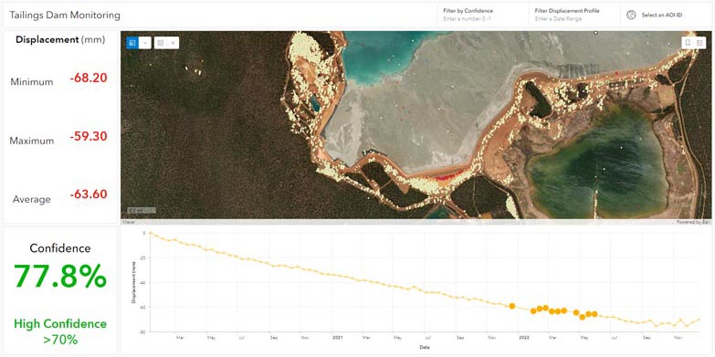
Organizations around the globe are currently using ENVI Inform to determine acceptable ground movement and detect instability that requires further analysis. One recent customer, Satellite Applications Catapult (SAC), a not-for-profit, innovation and technology organization, partnered with NV5 Geospatial as part of its work with the Church of England Pension Board to demonstrate that space-based data could be used to create an effective ground-motion monitoring service for mine tailings dams. Read more about this application here.