X
1460 Rate this article:
4.3

A New Era of Hyperspectral Imaging with ENVI® and Wyvern’s Open Data Program

Joey Griebel

This blog was written in collaboration with Adam O’Connor from Wyvern.


As hyperspectral imaging (HSI) continues to grow in importance, access to high-quality satellite data is key to unlocking new insights in environmental monitoring, agriculture, forestry, mining, security, energy infrastructure management, and more. Wyvern’s Open Data Program provides free access to visible and near-infrared (VNIR) hyperspectral data, allowing users to explore and analyze imagery at an impressive 5.3m ground sample distance (GSD).

At NV5, when new remote sensing data sources become available, we make sure to integrate them quickly so our users can take advantage of the latest advancements. That’s why ENVI supports Wyvern’s hyperspectral satellite data, giving users the ability to seamlessly ingest, visualize, and analyze this powerful dataset.


What Makes Wyvern’s Hyperspectral Data Valuable?

Wyvern provides VNIR hyperspectral imagery at 5.3m GSD, which means each pixel represents 5.3 meters on the ground. This resolution is ideal for applications requiring a balance between spatial detail and regional coverage. Wyvern data provides:

  • High enough resolution to distinguish vegetation types, land cover changes, manmade objects, and surface materials while covering large areas efficiently.

  • Detection of vegetation stress, crop health, yield prediction, and forest tree speciation while keeping data sizes manageable for fast processing in ENVI.

  • Ability to perform environmental conservation monitoring and remediation assessments, as well as support humanitarian assistance and disaster response (HADR) efforts, where detecting large-scale patterns is more critical than fine details

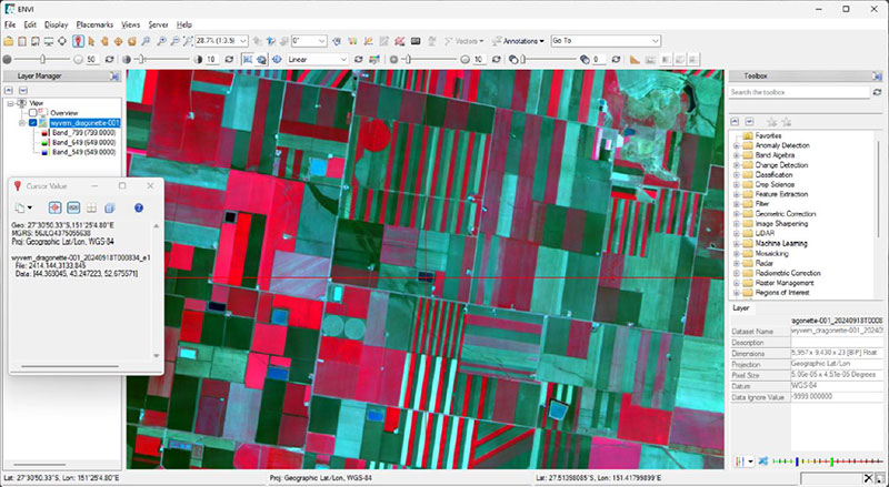
Wyvern Dragonette-1 imagery data product loaded into the ENVI software (CIR).

Real-World Applications for Wyvern Hyperspectral Data Processed in ENVI

  • Agriculture & Forestry: Detect plant stress, measure chlorophyll content, fertilizer optimization, early detection of pests, invasive plants identification, and classify both crop types and tree species.

  • Mining and Oil & Gas: Operational site monitoring, reclamation and remediation, ecosystem restoration, water quality monitoring, and regulatory compliance.

  • Disaster management: Analyze flooding, wildfire damage, fuel mapping to optimize mitigation efforts, tornado and hurricane damage mapping, and deforestation impacts over vast areas.

ENVI: The Industry Standard for Hyperspectral Data

As the definitive leader in spectral image processing, ENVI is designed to handle all types of remote sensing data, including hyperspectral, multispectral, LiDAR, and SAR. With ENVI, users can:

  • Seamlessly open and visualize Wyvern data with native support for easy ingestion.

  • Perform advanced preprocessing such as atmospheric corrections, radiometric calibration, and spectral filtering.

  • Extract actionable insights by generating spectral indices, classifying land cover, detecting anomalies, identifying materials, performing change detection, and creating custom analysis workflows.

For those interested in exploring ENVI’s capabilities with real-world hyperspectral satellite data, Wyvern’s Open Data Program provides a valuable opportunity to work with fresh imagery.

Alongside this launch, Wyvern has developed a dedicated ENVI Tutorial to help users ingest and preprocess imagery for accurate analysis and generate products for research and decision making. Whether you’re a researcher, analyst, or geospatial professional, this is an excellent opportunity to test the latest hyperspectral imaging technology with industry-leading analytics software.