Utilizing free satellite imagery to focus maintenance efforts in rail corridors
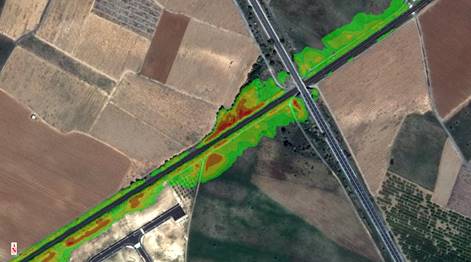
As sources of free satellite imagery like Sentinel-2 from ESA become more widely available, they will offer a unique ability to focus efforts for UAS collects and teams being fielded for maintenance efforts along rail corridors. Using the spectral information being collected by Sentinel-2 every 5 days and ENVI’s spectral analysis tools, those in charge of planning and scheduling the UAV and maintenance teams could put together a tipping and cuing system to focus their efforts. With Sentinel-2 flowing into S3 buckets on AWS, you could have your regions of interest along the rail corridor (or Utilities or Pipeline Corridor) and be continually running the automated vegetation hazard workflow our team has created and get alerts when a region has results of concern returned. The workflow calculates risk based upon vegetation health as well as the distance it is from the infrastructure focused on and returns an output similar to the image below.

(Credit Alberto Meroni)
Being alerted to regions of concern, as opposed to having to fly thousands of miles with a UAS in sight to find those concerns allows the UAS data collection teams, as well the maintenance teams being dispatched to mitigate these concerns, to focus their efforts on a microlevel and get to additional concern areas faster.

While this example focused on running the workflow along a rail corridor, the same principle would apply along a utility corridor or along an oil and gas pipeline, which would come in handy in some of the remote and desolate stretches before sending boots out there to investigate. The analysis can be taken one step further, using time 1 results and time 2 results with ENVI’s image change workflow to allow those tasking to validate that the risk has been mitigated and the maintenance completed.
The use of freely satellite imagery will most likely never get to the level of resolution needed for most of these inspections, but what it does allow companies to quickly do is take that first pass of an area at macro scale and better plan their flights and how long they will be in an area.