X

NV5 Geospatial Blog

Each month, NV5 Geospatial posts new blog content across a variety of categories. Browse our latest posts below to learn about important geospatial information or use the search bar to find a specific topic or author. Stay informed of the latest blog posts, events, and technologies by joining our email list!


New ENVI Agent, IDL Agent, and GeoAgent Quick Guides

New ENVI Agent, IDL Agent, and GeoAgent Quick Guides

6/9/2026

The recent release of ENVI® Agent, IDL® Agent, and GeoAgent™ revolutionize how users interact with geospatial software. These agentic AI applications act as partners to plan, simplify, and execute complex workflows. Knowing where to start can be challenging for new users. To this end, we developed three new quick guides to... Read More >

Introducing NISAR Data Support

Introducing NISAR Data Support

6/5/2026

The release of ENVI® SARscape 6.3 in April 2026 includes preliminary support for NASA-ISRO SAR (NISAR) data. The NISAR mission is a joint Earth-observing satellite project between NASA and the Indian Space Research Organization designed to monitor changes in the planet’s land and ice surfaces using advanced radar imaging. It... Read More >

Monitoring Illegal Mining in the Amazon: Turning Persistent Data Into Actionable Insight

Monitoring Illegal Mining in the Amazon: Turning Persistent Data Into Actionable Insight

5/28/2026

Illegal mining over decades has constituted one of the most persistent and complex socio-environmental problems in the Brazilian Amazon. In recent years, with the increasingly intensive use of mechanized extraction, the associated environmental impacts—such as deforestation, intense soil disturbance, river siltation, and mercury... Read More >

From Answers to Action: Why ENVI and IDL Agents Go Beyond General AI

From Answers to Action: Why ENVI and IDL Agents Go Beyond General AI

4/20/2026

As generative AI tools like Claude and Gemini continue to gain traction, many organizations are asking the same question: Can general purpose AI actually support real geospatial workflows, or does it stop at surface-level answers? That question was front and center in our recent webinar, Meet Your New Partners in Science: ENVI... Read More >

Mapping Earthquake Deformation in Taiwan With ENVI

Mapping Earthquake Deformation in Taiwan With ENVI

12/15/2025

Unlocking Critical Insights With ENVI® Tools Taiwan sits at the junction of major tectonic plates and regularly experiences powerful earthquakes. Understanding how the ground moves during these events is essential for disaster preparedness, public safety, and building community resilience. But traditional approaches like field... Read More >

1345678910Last
«June 2026»
SunMonTueWedThuFriSat
31123456
78910111213
14151617181920
21222324252627
2829301234
567891011
12612 Rate this article:
4.8

Building Custom Workflows Just Got Easier

Jason Wolfe

Have you ever had a great idea for a custom tool in ENVI® but were put off by learning the ENVI API? Traditionally, this was the only way to chain together various tasks in a sequence, or to batch-process input files at once. The learning curve can be steep if you are not familiar with basic IDL and ENVI programming.

With the release of ENVI 5.5, building custom data-processing workflows in ENVI is much easier, thanks to the ENVI Modeler. This is a new visual programming tool that leverages the power of the ENVI API with a simple user interface to help you create and run workflows that you can deploy to desktop and enterprise environments. You can design simple or complex processes that combine different ENVI spectral tools, without having any knowledge of ENVI programming.

For example, suppose that you want to convert multiple red/green/blue (RGB) images to hue/saturation/intensity (HSI) color space and save the results to disk. If you write an ENVI API script to do this, you would have to manage input and output file references yourself. You may not know the task names to use, and you could spend a lot of time referring to the help for the correct names of parameters. You would need to know how to create a FOR loop (with the correct IDL syntax) to process multiple input files.

With the ENVI Modeler, you can connect building blocks called nodes to run a sequence of steps; for example:

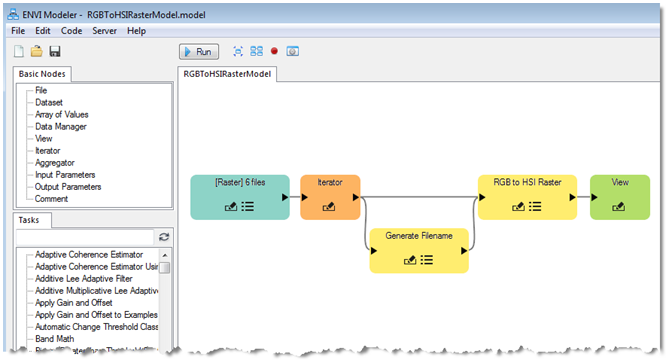
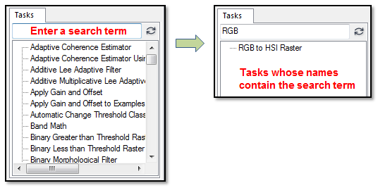
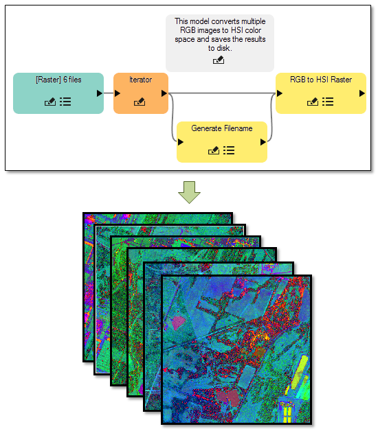
This model uses a File node (shown in the blue box) to point to six RGB input files. The primary job of this model is to perform an RGB-to-HSI conversion, so it needs a Task node that will do this. To find an appropriate task, you can enter a keyword in the Search field of the Tasks list:

In this case, the "RGB to HSI Raster" Task node will perform the RGB-to-HSI image conversion. An Iterator node allows you to batch-process the input files. Finally, a Generate Filename node lets you indicate where to save the output files, along with prefixes and extensions for the filenames. Running the model will produce six HSI images on disk:

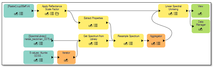
Here is another example of a model that runs through a full workflow for Linear Spectral Unmixing to determine the relative abundance of minerals in a hyperspectral image:

Once you have built a model, you can share it with others and deploy it in various ways:

  • Save a model as an extension that will be added to the ENVI Toolbox.
  • Create IDL or Python code from a model.
  • Create toolbox extensions for ArcMap and/or ArcPro.
  • Run a model on a Geospatial Services Framework (GSF) server.

Example models are available in the ENVI Help, to get you started. By having a visual programming tool available in ENVI, you can design workflows that contain any number of ENVI analytic tools. What will you create?

Please login or register to post comments.