X

NV5 Geospatial Blog

Each month, NV5 Geospatial posts new blog content across a variety of categories. Browse our latest posts below to learn about important geospatial information or use the search bar to find a specific topic or author. Stay informed of the latest blog posts, events, and technologies by joining our email list!


Not All Supernovae Are Created Equal: Rethinking the Universe’s Measuring Tools

Not All Supernovae Are Created Equal: Rethinking the Universe’s Measuring Tools

6/3/2025

Rethinking the Reliability of Type 1a Supernovae   How do astronomers measure the universe? It all starts with distance. From gauging the size of a galaxy to calculating how fast the universe is expanding, measuring cosmic distances is essential to understanding everything in the sky. For nearby stars, astronomers use... Read More >

Using LLMs To Research Remote Sensing Software: Helpful, but Incomplete

Using LLMs To Research Remote Sensing Software: Helpful, but Incomplete

5/26/2025

Whether you’re new to remote sensing or a seasoned expert, there is no doubt that large language models (LLMs) like OpenAI’s ChatGPT or Google’s Gemini can be incredibly useful in many aspects of research. From exploring the electromagnetic spectrum to creating object detection models using the latest deep learning... Read More >

From Image to Insight: How GEOINT Automation Is Changing the Speed of Decision-Making

From Image to Insight: How GEOINT Automation Is Changing the Speed of Decision-Making

4/28/2025

When every second counts, the ability to process geospatial data rapidly and accurately isn’t just helpful, it’s critical. Geospatial Intelligence (GEOINT) has always played a pivotal role in defense, security, and disaster response. But in high-tempo operations, traditional workflows are no longer fast enough. Analysts are... Read More >

Thermal Infrared Echoes: Illuminating the Last Gasp of a Dying Star

Thermal Infrared Echoes: Illuminating the Last Gasp of a Dying Star

4/24/2025

This blog was written by Eli Dwek, Emeritus, NASA Goddard Space Flight Center, Greenbelt, MD and Research Fellow, Center for Astrophysics, Harvard & Smithsonian, Cambridge, MA. It is the fifth blog in a series showcasing our IDL® Fellows program which supports passionate retired IDL users who may need support to continue their work... Read More >

A New Era of Hyperspectral Imaging with ENVI® and Wyvern’s Open Data Program

A New Era of Hyperspectral Imaging with ENVI® and Wyvern’s Open Data Program

2/25/2025

This blog was written in collaboration with Adam O’Connor from Wyvern.   As hyperspectral imaging (HSI) continues to grow in importance, access to high-quality satellite data is key to unlocking new insights in environmental monitoring, agriculture, forestry, mining, security, energy infrastructure management, and more.... Read More >

1345678910Last
15012 Rate this article:
5.0

ENVI -- On a mission

Anonym

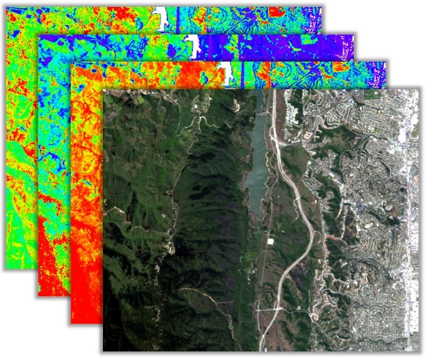
When you’re in the foothills or mountains of Afghanistan or Iraq, a statement like “identify targets and threats to get the actionable intelligence you need” is appealing. And while “improve your situational awareness with ENVI” is a marketing claim, when you’re in theater, using the technology does saves lives.

Just a few years ago, I was one of the many individuals that were prevented from executing “Out-side the Wire missions”. What that means is because there were identified threats that would have jeopardized my life and the lives of those I was charged to protect, we had to get creative about getting the job at hand done. Our mission was to enable the rebuilding of a country without engaging the enemy. ENVI not only provided a way to ensure mission effectiveness, but helped us successfully navigate through hostile territory with a high level of confidence that we would not be engaged by enemy forces.

Today I support NV5 (formerly Harris) to expand ENVI's capability and bring it to a wider market. As a Contracts professional, my organization ensures the safe deployment of the ENVI product which means following and enforcing government and commercial regulations that allow NV5 to provide civil, commercial as well as military use. ENVI software solutions are widely being used to: 

  • Quickly identify mineral deposits using hyperspectral imagery
  • Develop models to improve predictability of weather patterns
  • Improve situational awareness about unknown terrain before a mission even gets started

As these capabilities are incorporated into an organization, they must be vetted to ensure they are legally integrated into existing software and appropriately licensed to various users in accordance with their needs. Contract Managers are at the front line of ensuring success in getting the product to market and getting it into the hands that need it.

It’s been several years since I have been a customer of the robust capabilities offered by ENVI. There are many new threats facing our military members. ENVI continues to rise to meet those challenges by providing an even higher level of confidence today.  ENVI will help today’s war-fighters successfully complete their missions and return safely. Better yet, ENVI can thwart disaster by providing the GIS that identifies a high-risk threat that jeopardizes the lives of our military members before they get into harm’s way. As a contract professional ensuring the success of ENVI is more than making a sale, it’s a new mission.

1 comments on article "ENVI -- On a mission"

Avatar image

Mujahid Husain

how can i join special training session?

Please login or register to post comments.