ENVI® : The Toolkit of Choice for D&I Analysts
Kevin Wells
For many years ENVI® has been the toolkit of choice for scientists developing new algorithms and tradecraft for the Intelligence Community. However, there are many analyst-friendly tools that live in ENVI that you may not know about.
ENVI is currently used by Analysts on the DCGS-A and IEC systems for topographical and image analysis. For example, ENVI workflows can be used to detect changes and anomalies to support indications and warning (I&W), identify, characterize and extract features, model topographic characteristics to enable 2D and 3D mapping and more. With ENVI already installed on these baseline systems, Analysts can rely on ENVI for their image visualization and data processing tasks.
Intelligence Fusion with Easy-to-Use MULTI-INT Capabilities
ENVI can read a variety of datasets from national, commercial, and airborne platforms. So, whether it’s finding answers to tough Intelligence problems, supporting a homeland security mission, or supporting humanitarian aid and disaster relief (HADR), ENVI tools help users utilize the most appropriate data for their mission. This ease of use improves the confidence you have in the products you create.
- Use ENVI workflow tools for assisted creation of products such as pan sharpened images, LOCs, and target detection
- Create new tradecraft using “drag and drop” objects and without writing code
- Integrate ENVI analytics with your existing GIS from ArcMap or via ArcGIS Online
ENVI also provides connectivity to data via community hosts including GRID, WCS, OSM, and other OGC compliant services to support data search and discovery. This connectivity to community data and services allows Analysts to collaborate with other intelligence disciplines to develop a common intelligence picture (CIP) and a common operating picture (COP) to inform leaders and decision-makers. ENVI is also integrated with the Jagwire™ product line to provide accessibility of motion imagery and exploitation in support of real-time intelligence.
ELT Functionality
ENVI offers intuitive image visualization and interaction that provides easy image interaction such as pan, zoom, roam and snail trail. ENVI supports advanced mensuration utilizing MSP, as well as imagery intelligence (IMINT) tasks like feature identification, characterization, feature counting and Intelligence reporting. Other ELT functionality includes:
- EEGI shapefile extraction and export
- Annotate images with overlay text graphics
- Layer stack data for quick comparison, change detection and further processing
- Preview Portal
- Exportable snail-trail and the next shift can pick up where you left off
- Multiple linkable views (MADD) with side-by-side multi-views enabling quick and easy comparison and change detection
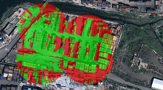
The figure above shows our viewshed analysis raster displayed over GeoEye imagery in ENVI.
Intelligence Product Creation
ENVI makes it easy to create and share intelligence reports with annotations, image within image features, and export to PowerPoint format capabilities. ENVI has built-in product templates that are consistent with current Department of Defense (DoD) and Intelligence Community (IC) standards. These templates enable rapid report generation because they are automated and dynamic with auto-populate functionality that updates grid coordinates, auto-orients and updates north arrow, dynamically auto-updates reference maps and auto-populate legends.

JAGWIRE OVERVIEW
Jagwire delivers critical intelligence to the field.
WEBINAR
Actionable geospatial intelligence for Defense and Security applications.

D&I SOLUTIONS
NV5 offers custom and off-the-shelf D&I solutions.