X

NV5 Geospatial Blog

Each month, NV5 Geospatial posts new blog content across a variety of categories. Browse our latest posts below to learn about important geospatial information or use the search bar to find a specific topic or author. Stay informed of the latest blog posts, events, and technologies by joining our email list!


NV5 at ESA’s Living Planet Symposium 2025

NV5 at ESA’s Living Planet Symposium 2025

9/16/2025

We recently presented three cutting-edge research posters at the ESA Living Planet Symposium 2025 in Vienna, showcasing how NV5 technology and the ENVI® Ecosystem support innovation across ocean monitoring, mineral exploration, and disaster management. Explore each topic below and access the full posters to learn... Read More >

Monitor, Measure & Mitigate: Integrated Solutions for Geohazard Risk

Monitor, Measure & Mitigate: Integrated Solutions for Geohazard Risk

9/8/2025

Geohazards such as slope instability, erosion, settlement, or seepage pose ongoing risks to critical infrastructure. Roads, railways, pipelines, and utility corridors are especially vulnerable to these natural and human-influenced processes, which can evolve silently until sudden failure occurs. Traditional ground surveys provide only periodic... Read More >

Geo Sessions 2025: Geospatial Vision Beyond the Map

Geo Sessions 2025: Geospatial Vision Beyond the Map

8/5/2025

Lidar, SAR, and Spectral: Geospatial Innovation on the Horizon Last year, Geo Sessions brought together over 5,300 registrants from 159 countries, with attendees representing education, government agencies, consulting, and top geospatial companies like Esri, NOAA, Airbus, Planet, and USGS. At this year's Geo Sessions, NV5 is... Read More >

Not All Supernovae Are Created Equal: Rethinking the Universe’s Measuring Tools

Not All Supernovae Are Created Equal: Rethinking the Universe’s Measuring Tools

6/3/2025

Rethinking the Reliability of Type 1a Supernovae   How do astronomers measure the universe? It all starts with distance. From gauging the size of a galaxy to calculating how fast the universe is expanding, measuring cosmic distances is essential to understanding everything in the sky. For nearby stars, astronomers use... Read More >

Using LLMs To Research Remote Sensing Software: Helpful, but Incomplete

Using LLMs To Research Remote Sensing Software: Helpful, but Incomplete

5/26/2025

Whether you’re new to remote sensing or a seasoned expert, there is no doubt that large language models (LLMs) like OpenAI’s ChatGPT or Google’s Gemini can be incredibly useful in many aspects of research. From exploring the electromagnetic spectrum to creating object detection models using the latest deep learning... Read More >

1345678910Last
«September 2025»
SunMonTueWedThuFriSat
31123456
78910111213
14151617181920
21222324252627
2829301234
567891011
15988 Rate this article:
5.0

GEOINT means exciting technology

Anonym

Beau Leeger, Manager of US Sales and Services at NV5 (formerly Exelis VIS), is guest blogging today about exciting technology that will be on display next week at GEOINT.

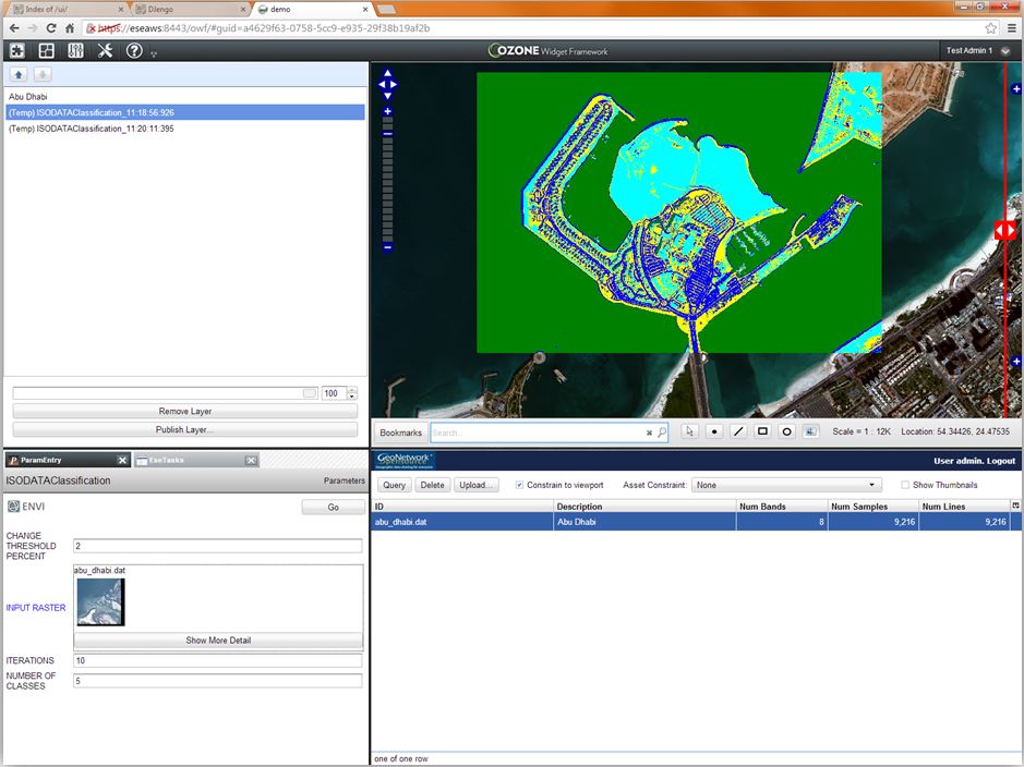
In just five days, GEOINT 2013* begins. The re-scheduling the 2013 edition of my favorite conference allowed for us to extend our cloud based, on-demand geospatial offerings with some potentially game-changing technology. For several years now, I have watched the development and excitement around the Ozone Widget Framework (OWF). To my delight, this technology was released to the general public in early 2013. We immediately went to work on using this flexible "widget" based technology to host components for on-demand geospatial data exploitation. The resulting client stack includes widgets for accessing catalogs and performing advanced geospatial exploitation using ENVI-powered tools. There is even a widget that allows for web-based viewing of point-clouds from LiDAR. Within the framework, a user can interactively build a dashboard that hosts a functional geospatial exploitation application that runs and accesses data within the cloud. The power to for anyone to build web-based, cloud-powered geospatial exploitation tools is now within reach.

I am most excited about the possibilities when these tools are hosted in a flexible, interconnected framework. The design intent of OWF was to bring the source of information from various agencies and contributors together to get a more complete view of a problem or situation. This original goal is now extended into the geospatial realm. The ability to bring all relevant data sources and exploitation together to solve difficult geospatial problems is within reach. Image scientists and researchers will have a framework to develop tools that can interoperate with tools developed by others. Analysts will be able to deploy these tools shortly after development to solve pressing time-critical problems. The future of cloud-powered, web/mobile-based geospatial exploitation is suddenly much brighter.

What do you think about this exciting development? Experience this with us at GEOINT and let us know how it fits into your visions and aspirations for the future of geospatial exploitation.

Please login or register to post comments.