X

NV5 Geospatial Blog

Each month, NV5 Geospatial posts new blog content across a variety of categories. Browse our latest posts below to learn about important geospatial information or use the search bar to find a specific topic or author. Stay informed of the latest blog posts, events, and technologies by joining our email list!


Monitoring Illegal Mining in the Amazon: Turning Persistent Data Into Actionable Insight

Monitoring Illegal Mining in the Amazon: Turning Persistent Data Into Actionable Insight

5/28/2026

Illegal mining over decades has constituted one of the most persistent and complex socio-environmental problems in the Brazilian Amazon. In recent years, with the increasingly intensive use of mechanized extraction, the associated environmental impacts—such as deforestation, intense soil disturbance, river siltation, and mercury... Read More >

From Answers to Action: Why ENVI and IDL Agents Go Beyond General AI

From Answers to Action: Why ENVI and IDL Agents Go Beyond General AI

4/20/2026

As generative AI tools like Claude and Gemini continue to gain traction, many organizations are asking the same question: Can general purpose AI actually support real geospatial workflows, or does it stop at surface-level answers? That question was front and center in our recent webinar, Meet Your New Partners in Science: ENVI... Read More >

Mapping Earthquake Deformation in Taiwan With ENVI

Mapping Earthquake Deformation in Taiwan With ENVI

12/15/2025

Unlocking Critical Insights With ENVI® Tools Taiwan sits at the junction of major tectonic plates and regularly experiences powerful earthquakes. Understanding how the ground moves during these events is essential for disaster preparedness, public safety, and building community resilience. But traditional approaches like field... Read More >

Comparing Amplitude and Coherence Time Series With ICEYE US GTR Data and ENVI SARscape

Comparing Amplitude and Coherence Time Series With ICEYE US GTR Data and ENVI SARscape

12/3/2025

Large commercial SAR satellite constellations have opened a new era for persistent Earth monitoring, giving analysts the ability to move beyond simple two-image comparisons into robust time series analysis. By acquiring SAR data with near-identical geometry every 24 hours, Ground Track Repeat (GTR) missions minimize geometric decorrelation,... Read More >

Empowering D&I Analysts to Maximize the Value of SAR

Empowering D&I Analysts to Maximize the Value of SAR

12/1/2025

Defense and intelligence (D&I) analysts rely on high-resolution imagery with frequent revisit times to effectively monitor operational areas. While optical imagery is valuable, it faces limitations from cloud cover, smoke, and in some cases, infrequent revisit times. These challenges can hinder timely and accurate data collection and... Read More >

1345678910Last
«June 2026»
SunMonTueWedThuFriSat
31123456
78910111213
14151617181920
21222324252627
2829301234
567891011
11847 Rate this article:
5.0

Landsat Program Well Worth It's Price Tag

Anonym

A recent report by the Landsat Advisory Group of the National Geospatial Advisory Committee took a rigorous look at the value of Landsat-based information over the lifetime of the program. Their conclusion, not surprisingly, shows that Landsat has provided a spectacular return on public investment. The paper reports that the economic value of just one year of Landsat data, estimated to be $2.19 billion, far exceeds the total cost of building, launching and managing Landsat instruments.

The fact that Landsat data is most often used by non-commercial entities makes it difficult to estimate its economic value. Nevertheless, the committee was able to form an estimate based on cost savings from operational efficiency improvements, cost of alternatives to using Landsat data, and opportunity costs due to decision-making support provided by Landsat data. 

The report asserts that people use Landsat because it is more efficient than any other technology at providing required information. It concludes that the savings realized due to the Landsat program will continue to accelerate as the program continues.

Faults in Xinjiang
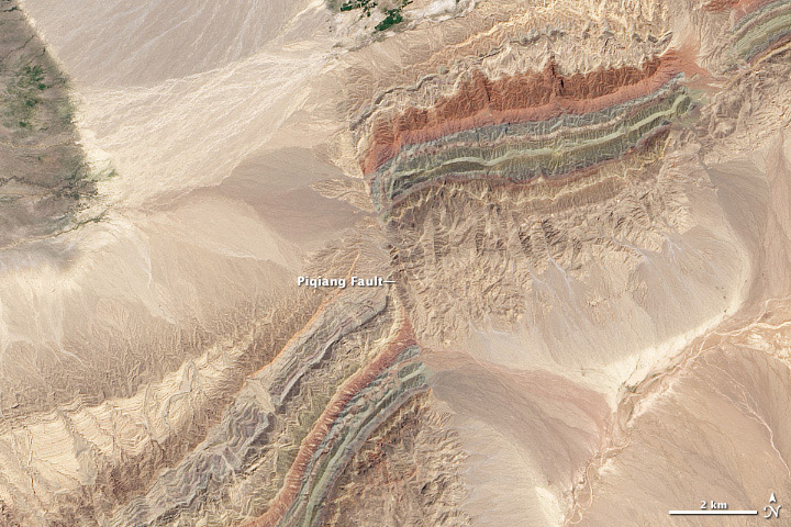
Landsat 8 OLI image of the Piqiang Fault in The northwestern Xinjiang province of China acquired on July 30, 2013. This beautiful image was the winner of NASA's 2015 Tournament Earth contest. (Courtesy of the NASA Earth Observatory)

Please login or register to post comments.