Remote Sensing for Oil & Gas
Modern Data & Analytics for the New Age of Surface and Above-Surface Exploration, Operations, Environmental Monitoring, & Health and Safety Applications
Anonym
Modern Data & Analytics for the New Age of Surface and Above-Surface Exploration, Operations, Environmental Monitoring, and Health and Safety Applications
Remote Sensing and associated technologies are not new. In fact, they have been around for several decades. However, use of “above surface” information has not been widely utilized in the past 30-40 years of oil and gas exploration and operations. Instead – sub-surface analyses have been more pervasive for several reasons. Understanding what is happening beneath the Earth’s surface is important for accurate reservoir and flow modeling, which leads to more informed production decisions and the ability to produce more energy for less. Because of the importance to understand what is happening beneath the Earth’s surface, magnetic, and gravimetric data collection methods have been refined and perfected as have associated analysis tools for these data sources. Companies like Geosoft, Dynamic Graphics Inc., Paradigm, and many others have spent years to create modeling tools and analysis workflows for the industry.
While below-surface analytics have been perfected over the years, surface and above-surface remote sensing solutions have had a few shortcomings in the realm. The low spatial resolution and spectral resolution of many data sources have made it difficult to quantify and delineate spills, or even identify alteration minerals beyond a regional scale. Surface features have been proven obstructions to locating previously unknown fault locations. Low revisit rates of many imaging platforms have proven to be a barrier to broad-scale temporal analyses.
These barriers were real, but are no longer present. Modern imaging solutions including satellite constellations with high revisit rates, new SAR sensors (Sentinel-1 for example) delivering free or very low cost data, and UAS payloads with an unlimited number of different data sources are the way of the present. The data are available as are modern analysis tools working along-side to bring comprehensive solutions to the marketplace.
For example, new faults are easily identified using LiDAR (figure 1) to differentiate bare earth surface points from above ground points. This enables the identification of faults that were previously not detectable, sometimes in very remote locations. Additionally, temporal models such as very high resolution (cm scale) surface models generated from LiDAR enable small-scale changes over time to be identified long before they become a hazard.
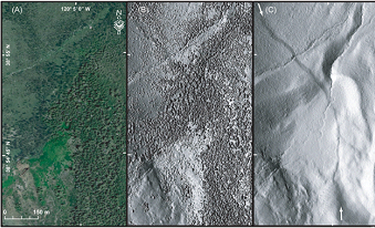
Figure 1: LiDAR-derived fault. Left, true color image. Middle, LiDAR-derived surface model. Right, LiDAR-derived bare earth model showing fault.
LiDAR is not the only pervasive data source for above-ground analysis that can facilitate lower cost to market and greater control over environmental impact. Interferometric processing of Synthetic Aperature Radar (SAR) data enables land subsidence mapping to the mm scale to identify subsidence patterns long before a landslide or other disaster occurs (figure 2). Higher spatial resolution and spectral resolution of optical imagery from satellite or airborne sources are also available making fine-scale spill delineation, vegetation monitoring, and localized mineral mapping much more accessible than ever before. Video capture and processing enables operations inspections to take place in real-time, without the need to pause production or put ground crew in harm’s way.
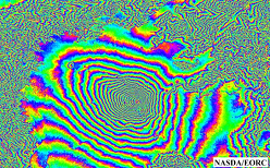
Figure 2: Inteferrogram derived from SAR data. Image courtesy of NASDA/EORC.
Using the ENVI® software, no matter what the data format or source modality, you can be assured that the ingestion, processing, exploitation, and dissemination are seamless. During the same 30 years that the energy industry has been perfecting below-surface modeling analytics, ENVI scientists have been perfecting expert quality analytics to extract meaningful information about what is happening at the surface and above — regardless of the data source.