dPlan Simplifies UAV Surveillance Mission Planning
Anonym
When an Unmanned Aerial Vehicle (UAV) operator plans a surveillance mission, success depends on many variables. The mission plan must weigh the capabilities of the UAV and its sensor package against the quality of information required at each target location. After all, some surveillance tasks are more demanding than others and may require a clearer look.
The defense and intelligence community developed NIIRS (National Image Interpretability Rating Scale) to quantify what information may or may not be extracted from an image. Analysts use NIIRS to communicate the level of image quality they need to perform a specific intelligence task. An optimized mission plan will put the right UAV payload on a route that maximizes the quantity and quality of information (i.e., high NIIRS) collected while minimizing the cost of flight operations.
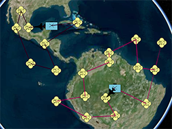
Marisa Gioioso, a Research Scientist at Milcord LLC, has been working on a product called dPlan that she says simplifies this process. “With dPlan, all the factors that need to be considered, like route, availability and priority of the target, and the NIIRS needed, are combined into one cost function,” said Gioioso. “Using the cost function, dPlan will find the optimal route describing where all of the UAVs in a mission should go, and in what order. It will also do a cost-benefit analysis to indicate if the UAV cannot reach all targets, which target might be the lowest cost to remove from the plan, or whether another UAV can visit the target instead.”
Milcord and NV5 (formerly Exelis VIS) have been working together on dPlan. Milcord is providing the web-based user interface and the UAV optimization/routing algorithm (a fast genetic algorithm and fitness function) and NV5 is providing analytical services that perform the NIIRS and line-of-sight (target access) calculations. “The user specifies the target’s location, time window and what NIIRS is needed. The user may have intelligence that suggests a target is a tank, so they know they will need, say, a NIIRS 5 image to confirm it,” explains Gioioso.
“dPlan will send the user’s required NIIRS value, as well as flight altitude and other details to ENVI Services Engine (ESE), and then ESE sends back a map indicating line of sight and NIIRS values for a grid of points surrounding the target location. Based on that grid, dPlan decides which UAV to assign to that target and where to put the waypoint. So, if the user only requires a NIIRS 1 (least resolution) for a particular target, then the UAV does not have to fly as close and can still get a good enough picture of the target while minimizing fuel consumption. But if a NIIRS 9 is required, the UAV may need to fly directly overhead and/or change altitude.” In the end, this collaboration combines the expertise from both companies in an easy-to-use web application that can scale to any mission size.