On Tuesday, March 3, 2020, a tornado with wind speeds reaching 165 mph swept through the Nashville suburbs killing more than 20 people and reducing hundreds of homes and buildings to rubble.
“Identifying building damage with Machine Learning is a challenge because ‘damage’ doesn’t have a specific appearance or shape,” explained Austin Coates, Sales Engineering Manager at NV5. “Damage will look different for just about every building or home.”
Finding houses, airports or roadways with Machine Learning is much simpler because each of these features – although different in many ways – have multiple common characteristics, including their shapes and construction materials, for example. But Coates was confident ENVI Deep Learning would pinpoint damaged or destroyed structures thanks to the complexity of its algorithms.
“The Machine Learning algorithms just need to be shown examples of the features to be found in the multispectral image data, and they evaluate the spatial, spectral and textural characteristics of that feature,” he said. “The algorithms use this training information to find other features or objects with the same characteristics.”
Working in ENVI Deep Learning, Coates manually examined small sections of the imagery to detect damaged buildings with his naked eye. He defined these examples, or training sites, by drawing polygons around them. Due to the wide variation in type and degree of structural destruction, he selected more training samples than he would normally.
In setting up Deep Learning training models, it’s standard procedure to pick clusters of examples in several small areas of the overall image. This allows the user to run quick tests on the model to see how it is performing. Coates followed this procedure and learned the algorithms were identifying damaged structures accurately but were also delivering false positives.
“Piles of debris in yards and rock quarries were identified as damaged buildings,” he said.
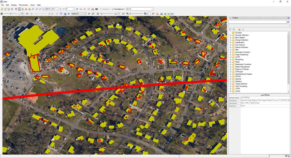
To further refine his models, Coates obtained open-source building footprint data from Nashville’s online GIS. By importing this data into the ENVI model, he focused the algorithms to look for damage in spaces defined by known building footprints. The result was an extremely accurate map showing the damaged structures in Nashville.
In addition, Coates created a similar, but much simpler, Deep Learning model to find blue tarps in the image. These tarps are traditionally used by FEMA and other relief agencies to cover damaged roofs after a storm. It should be emphasized that blue tarps would not be in place in imagery captured a day or two after the storm, so they could not be used for rapid response planning.