Accuracy Assessment of Passive Point Clouds
Background
Passive point clouds have become a pervasive data modality for remote sensing analyses. A passive point cloud is a three-dimensional dataset representing the horizontal and vertical position of everything on the surface of an area. These points are generated using photogrammetric algorithms that take advantage of the parallax between the images thus calculating a point in three-dimensional space for every corresponding image pixel. The result is often called a passive point cloud or photogrammetric point cloud.
Organizations with large data stores of existing stereo-satellite imagery are able to repurpose existing assets to generate new information, in this case elevation, to augment existing analyses or to solve new problems where elevation is important. Additionally, these point clouds are a by-product of algorithms used to align overlapping airborne imagery thus most projects utilizing manned or unmanned aircraft will have access to passive point clouds over their area of interest.
Problem
Passive point clouds are used to augment surveys, calculate volumes, perform precision measurements, and to add a vertical dimension to otherwise two-dimensional image data. Due to the multi-step processes used to generate these points, errors can often be introduced during the extraction process. The implication of these errors is probably inconsequential when the goal is to add three-dimensional context to data visualizations. However when precision measurements that impact safety are required it is paramount to quantify the data accuracy prior to performing additional analyses.
In order to quantify accuracy, ground control points (GCPs) are essential. These points often come from ground survey equipment and are the gold-standard for accurate reference information. However, a common challenge introduced when using these points is that the survey reference projections are often different than the image collection reference projections. As a result, re-projecting data adds another layer of complexity and is usually a factor in performing accuracy assessments for these data layers.
Solution
ENVI has the unique ability to automatically import reference points from a text file and to expose their map projection information during the process. Access to existing projections or custom projections enables the user to specify the collection reference, and the software automatically converts the input as needed such that the GCPs and the point clouds align in the same spatial framework. In addition, unit conversions are applied in cases where the airborne platform and ground control are collected differently. Performing these coordinate and unit conversions are essential for a truly accurate comparison of the GPCs and point clouds.
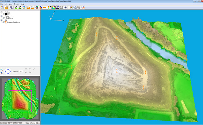
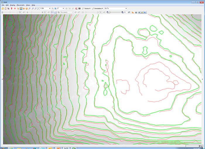
Prior to calculating any vertical accuracy, it is best practice to also visually inspect the horizontal alignment between datasets. If the ground survey process includes contour derivation, horizontal comparison is easily accomplished by rendering a digital surface model (DSM) from the point cloud then generating surface contours at the same intervals of the survey contours. A simple overlay can give a general understanding of the quality whereas horizontal accuracy can be quantified by measuring the variability in either dimension.
Once it is determined that the horizontal accuracy is within the project specifications, and after the coordinate and unit conversions have been performed, the vertical accuracy is calculated easily using the ENVI Generate Precision Report tool. This tool calculates the difference between the point elevations in the point cloud versus the reported elevations at each GCP. From there, accuracy metrics are reported including overall and mean accuracy as well as standard deviation.
Conclusion
With the influx of data coming from both manned and unmanned airborne platforms, photogrammetrically generated point clouds have become a pervasive data source. Determining the accuracy of these passive point clouds is an important step to verify that these derived data are suitable to meet project requirements. With tools such as ENVI, the coordinate and unit conversions, visual inspections, and automated calculations make it easy to quantify accuracy.