ENVI for ArcGIS® - Services Edition : Image Processing for the Cloud
INTRODUCTION
NV5 Geospatial has recently released a new version of its popular ArcGIS®-enabled ENVI software. The ENVI image processing software has long been best in class for image analysis and visualization. With an ENVI desktop license, ENVI image analysis tools are readily available in the ArcGIS environment and can be used within ArcGIS or leveraged as part of a geoprocessing model. Now, with the latest release of ENVI for ArcGIS – Services Edition, deployment of image and GIS processing tools to the enterprise is an easy reality. With the desktop and server integration of ENVI and ArcGIS, once tools and models are built they can be published to users across the enterprise. This enables ENVI image analysis tools and models to be readily available and utilized across your entire organization within the ArcGIS product suite.
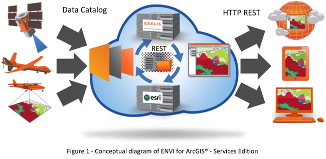
With the latest release, ENVI for ArcGIS – Services Edition operates in a RESTful state using the Geoservices REST specification, which means services are self described and easy to implement from ArcGIS for Server. These calls initiate a data processing operation once those messages are registered. See Figure 1 for a conceptual example. This type of implementation means minimal changes to existing ENVI scripts or geoprocessing models. ENVI for ArcGIS – Services Edition comes with an easy installer and a reference implementation so users can get up and running quickly and with minimal IT overhead.
BENEFITS OF ENVI FOR ARCGIS – Services Edition
- Minimal to no modification of existing ENVI and IDL scripts
- Plugs into existing ArcGIS for Server architecture
- Option to wrap ENVI actions in a geoprocessing model or use the Geoservices REST approach REST
- Take advantage of scalable architecture by running on multiple processors and multiple server nodes of enterprise systems
- Integrate advanced image processing approaches with ArcGIS spatial analysis techniques
- Access image analysis from any device
- Easy deployment of image processing web services for the enterprise or client applications
- Deploy to common cloud environments like Amazon Web Services
- NV5 Geospatial Professional Services for ENVI code development, custom client applications, and system configuration
EXAMPLES OF ON DEMAND IMAGE PROCESSING WORKFLOWS
Coupling ENVI with ArcGIS for Server means that you can seamlessly integrate image processing workflows and results in a modern, services-oriented approach. It’s never been easier to integrate GIS and Remote Sensing. Below are some examples to help illustrate these benefits.
|
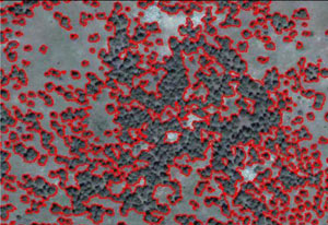
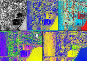
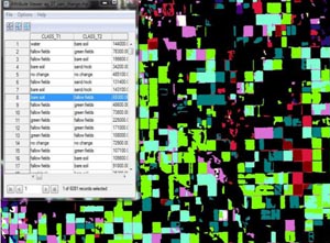
Segmentation: Group areas with similar spatial and spectral statistics into objects from imagery. Imagery stores can be segmented using ENVI for ArcGIS and quickly provide groupings of key cover types.
|
 |
|
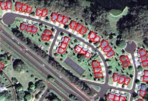
Feature Extraction: Extract features such as buildings, roads, impervious surfaces, trees…etc. using spatial and spectral information. In a server environment, a user could request a certain type of object search on a data archive. Feature Extraction over time can result in time series and change analysis to better understand population growth and habitat changes.
|
 |
|
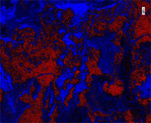
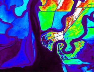
Disturbed Vegetation/Habitat Mapping: Use imagery to identify areas where vegetation is changing relative to other cover types. Find vegetation that is impacted by contaminates or proximity to borders, discover habitat islands, or unique habitat areas. With ENVI for ArcGIS, imagery collected over a growing season or multiple years could be analyzed for change or to determine where disturbed vegetation is found relative to the rest of the image.
|
 |
|
Vegetation Health: Use imagery to map vegetation health using a wide range of scientifically proven indices, implement statistical analysis from field work, or study quantitative decreases or increases in vegetation. In a cloud environment, long term stores of Landsat data can be analyzed for changes in forested areas with results of that analysis consumed by a carbon model.
|
 |
|
Water Quality: Use imagery to look for unusual discharge, increased nitrogen run off, or changes in aquatic vegetation and queue areas for closer inspection. Coastal imagery could quickly be called up to look for trends in water quality and results used for health alerts like beach closures and seafood safety warnings.
|
 |
|
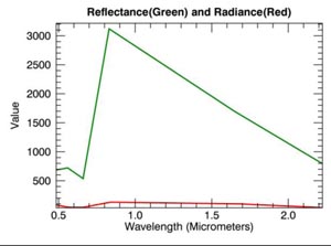
Calibration and Atmospheric Correction: Execute on-demand calibration and atmospheric correction of multispectral and hyperspectral data for ordering data or inclusion in an image processing application. These two steps are important to quantitative change detection and ENVI has many approaches for this process. Images could be corrected on the fly and results delivered interactively or the products used in another processing step.
|
 |
|
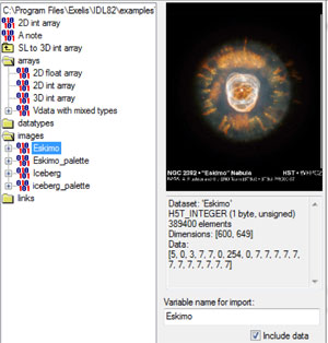
Converting Image Format: Use ENVI for ArcGIS to subset scientific data formats and export to more consumable outputs such as shapefiles, geodatabases, GeoTIFFs or KML/KMZ. Change data structures, number type, or band order and apply a wide variety of stretches to imagery for production and delivery.
|
 |
|
Change Vectors: Track vegetation health, urban changes, and agricultural trends over time and use that information to predict future behavior. NDVI could be performed on archival data and trends extracted from regions of interest. This information can be used for commodities analysis, food security, and climate analysis.
|
 |
SUMMARY
ENVI for ArcGIS – Services Edition is a unique solution for running advanced image analytics on imagery in the cloud. With the new enhancements to the product, it’s easier than ever to request and deliver results to the ArcGIS Environment. Imagery is everywhere; harness the power of analyzing it in the cloud or an enterprise based system with ENVI for ArcGIS - Services Edition.