31271
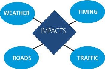
Weather’s Biggest Blind Spot: Helios in Transportation
BACKGROUND
Traditional industries that are linked to mobility, public safety, logistics and even issues concerning driver safety have been handcuffed by the weather data that’s been available to it – primarily satellite and radar. Although important, these tools leave businesses with a blind spot because they lack visibility into what is happening on the ground. Because of these shortcomings, companies are not able to make effective decisions regarding weather-related events.
BENEFITS:
- Improves street-level situational awareness and short-term weather forecasting by validating real-time ground conditions day and night
- Provides immediate access to weather condition analytics from an aggregated network of nearly 40,000 traffic, vehicle, and surveillance cameras
- Delivers 95% weather detection accuracy capturing hyperlocal extremes and short-lived severe events not detected by traditional methods
Why Satellite and Radar Aren’t Enough
While satellites and radar tell us a lot about the weather and are needed to forecast broad patterns, they leave large blind spots when gathering information about exactly what is happening on the ground. Current solutions only estimate what’s happening in the clouds and then predict an expected zone of impact, which can be very different than the actual zone of impact. As many know from experience, it is common for storms to have pockets with more intense storm damage, known as hyper-local storms. Ground based radar is also limited due to the curvature of the earth and terrain, leaving additional weather blind spots.
Helios Solves many aspects of the Data Blind Spot
Many companies have proposed solutions that aim to solve weather’s data blind spot. Could a possible solution lie in building new types of algorithms and expanding the data set in ways that have not been previously considered? The answer must lie in a marked improvement in the amount of the foundational data and new types of data that extend current and new algorithms. Weather in general has been associated with forecasting since its inception. However, weather impacts many businesses in many ways not addressed in a traditional forecast. It would not be useful to give a driver a forecast to determine what the road conditions will be ahead of him/her. Thus, Helios extends weather into the impacts of weather.
CCTV cameras as Weather Sensors
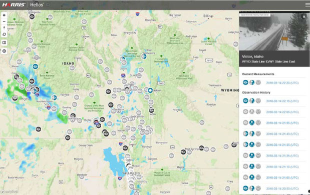
In general, the Internet of Things (IoT) has changed what is possible. To resolve this weather blind spot, Helios creates a new foundational weather sensor network from CCTV traffic cameras to detect “road weather”. Road weather concerns itself with not only on the current ground weather, but also the impact of the weather on critical transportation infrastructure and mobility in general. There is a global trend to increase camera coverage, thus Helios will continue to grow. On the other hand, static weather ground station hardware densities have likely peaked in most countries. Helios presents an ever growing, highly accurate ground weather condition data “detector”. A low-cost condition monitoring solution such as this is an ideal complement.
The Helios commercial ground weather analytic platform from NV5 Geospatial combines over 50,000 CCTV cameras into a ubiquitous network to surveil local ground weather and provide validation intelligence that enables companies and organizations to make real-time decisions based on what’s happening on the ground. In a sense, Helios is a ground “weather-observer.” It delivers ground condition states using machine learning to detect weather in video images from a large network of public and private cameras. The analytics instantaneously evaluates and filters content from thousands of existing public and private video cameras to detect weather conditions, trends, and activities. Helios provides immediate confirmation of ground weather condition changes at the camera location and combines it with other relevant ground data to give a ubiquitous picture of how weather is affecting critical infrastructure and mobility.
With validated analytics at greater than 95% ground condition detection accuracy, Helios is the only image-based, real-time localized ground conditions change notification system on the market today. With access to the full Helios API, you can also perform powerful searches and save imagery using recordings or collections, all from your desktop or mobile device. Our easy-to-use JSON API provides full access to all Helios data sources so you can incorporate the data you need into your own applications. Users can perform powerful queries using textual, spatial, and metadata filters. Live and archived camera imagery, current and historical weather observation data, and real-time alert data are all available with a few simple queries.
Application for Variable Speed Limits and Driver Warnings
The purpose of any speed limit sign is to inform drivers of the maximum acceptable and safe speed for normal travel conditions. However, if roadway conditions are less than ideal, such as during wet weather conditions, conventional static speed limit signs may not display an appropriate, reasonable, and/or safe speed limit for those conditions. The use of variable speed limit (VSL) systems during inclement weather or other less than ideal conditions can improve safety by decreasing the risks associated with traveling at speeds that are higher than appropriate for the conditions.
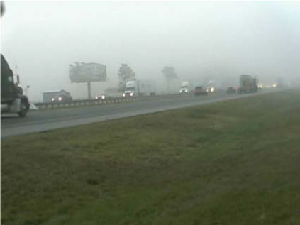
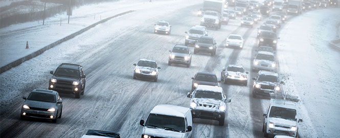
With fog, rain, and snow squalls being extremely localized and fast moving in nature, the importance of detecting such events are critical to improve driver safety. Fog banks move in and out of areas in minutes and snow squalls can drop inches of snow on limited segments of roads. Using existing CCTV traffic cameras as sources, Helios provides a dense network and actionable information in detections of road wetness, road snow cover, and visibility to inform transportation agencies of occurring weather that could affect altering of speed limits.
Application for Winter Road Maintenance
The large benefit of using weather information for winter maintenance is reducing maintenance cost. The perception that using weather information could save on staffing, materials/chemicals, and equipment costs was more likely to be reported by maintenance managers than by field crews/supervisors. More weather information is needed to support anti-icing and plowing/de-icing activities where accuracy of current conditions can be even more important than forecasts. There is correlation between reducing costs in winter maintenance and accurate conditions detection.
Helios’ real-time pavement conditions and visibility observations complement ground-based weather sensor hardware, providing a denser network for understanding the current condition, onset/end time of precipitation, and other trending data of roadway segments. Much of this data can also be used to input into pavement forecast models for snow removal and treatment. This data can provide near-term forecast correction and accuracy gains.
Fog is a major cause of traffic related deaths in the State of Florida. Florida Department of Transportation, Florida Polytech University, and NV5 Geospatial’s Helios program are collaborating with the goal to understand the occurrence and possible prediction of fog. The State of Florida has given Helios approximately 1,400 of its traffic cameras to produce road weather observations to date. Helios is being used to validate and fine tune forecast models.
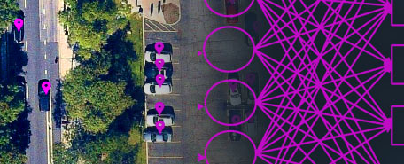
The Helios system uses machine learning technology to extract road weather conditions from traffic cameras every 5 minutes (visibility/fog, wet/dry/snow covered roads). The program has a co-share (private/public) partnership with FDOT’s Traffic System Engineering Maintenance and Operations Group to provide this capability to them, as well as to 13 autonomous Reginal Traffic Maintenance Centers to send driver safety warning messages to external messaging signs on the highway.
Using History to Predictive the Future?
Analysis of historic and real-time road weather events for specific road segments may open the door to predicting future events. Furthermore, the correlation of weather events and traffic incidents can offer a new understanding at the road segment level. This type of analysis could be the way forward toward a predictive method to not only index road segments, but offer advanced warning of likely weather events.
When You Can’t Control the Weather
Car accidents rank among the top 10 causes of death for humans worldwide. According to the U.S. Department of Transportation, more than 5,748,000 vehicle crashes occur each year with about 22% of those involving hazardous weather. Those weather-related automobile crashes kill an average of 6,000 people a year. In comparison, the 10-year average combined number of deaths per year from flooding, lightning, tornadoes, hurricanes, and heat is 375.
Weather-related vehicle crashes are caused by wet pavement, rain, snow/sleet, icy pavement, snow/slushy pavement, and fog. While it is impossible to control those weather-related events, Helios offers the possibility to mitigate the impacts. The Helios weather analytic platform offers industries involved in transportation the ability to access a larger set of real-time confirmation of hazardous ground weather condition changes to inform real-time decisions to save resources – time, money, and ultimately lives.
AUTOMATE ANALYTICS
Automate analytics with deep learning for fast, accurate results.
RECORDED WEBINAR
Watch this webinar to learn how Helios can help solve weather challenges.

VIDEO CASE STUDY
This video demonstrates how SAR data and analytics are used after a highway collapse.