What’s New in SARscape 5.5
This release of ENVI SARscape 5.5 has been highly anticipated because it includes two new powerful features found in ENVI – the ENVI task API (application programming interface) and ENVI Modeler.
New and enhanced features of this release include:
- SARscape tasks and metatasks are compatible with ENVI Modeler
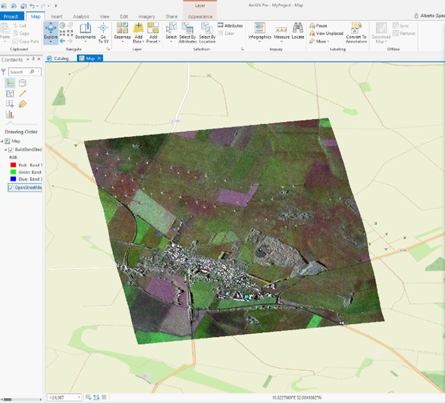
- SARscape processing can be run in ArcGIS® Pro (requires SARscape, ENVI, and ENVI Py 1.2)
- Additional SAR file support including ASNARO-2, SICD, and PAZ-1
- MICCD workflows in the Basic module generates an RGB composite of coherence temporal changes
- Interferometric Stacking – Incremental Persistent Scatterers and SBAS improve performance and reduce processing time
- Interferometry workflows without GCPs for InSAR DEM and Stereo DEM
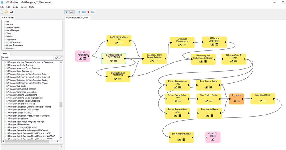
SARscape Tasks
In this release, SAR processing can be automated using the new SARscape tasks. Like ENVI tasks, the SARscape tasks encapsulate the processing of SARscape. The SARscape tasks work in the ENVI Modeler so the developer of SAR applications can visually program their custom workflows, saving a tremendous amount of time.
Integration with ArcGIS® Pro
Users of ArcGIS Pro can add SAR processing tools that leverage the power of ENVI and SARscape. The ENVI Py module is a standalone Python API that is available free to enable this integration of ENVI, SARscape, and ArcGIS Pro.
SAR and Other Data
Several new and improved data support enhancements are included in this release.
- Generic SAR data import is sensor/data format agnostic and is available in SARscape workflows
- New sensor support
- PAZ-1, a Spanish X-band SAR mission
- ASNARO, a Japanese X-band SAR mission
- New SICD (Sensor Independent Complex Data) support
- Sensors include: ALOS-2, COSMO-SkyMed, RADARSAT-2, Sentinel-1A/B, TerraSAR-X, and TanDEM-X
- Data improvements
- RISAT-1 Level 2 data support (an Indian SAR mission)
- Sentinel-1 Download facility
- Sentinel-1 Amazon format
- Other data types
- AIS (Automatic Ship Identification) marine traffic
- ECMWF (European Centre for Medium-Range Weather Forecasts) download
- OpenStreetMap download
Workflows
New workflow enhancements are available.
- MICCD (Multi Inverse Coherence Change Detection) workflow processing chain generates an RGB color composite for the visualization and identification of coherence temporal changes
- Two optional steps are available in all applicable workflows
- Generic data import
- Subsetting on AOI
- New Interferometry workflows without GCPs
Interferometric Stacking
New improvements include:
- Incremental PS (Persistent Scatterers)
- Adding images to the interferometric stack does not require recomputing the whole stack. Only the newer images are recomputed.
- SBAS (Small BASeline)
- Performance improvements in first inversion, second inversion and geocoding steps
- Improvements on intermittent phase measurements allow the fine tuning of thresholds during first and second inversion steps
- Improvements on height estimation to preserve the residual topography estimate from processing data resolution to the specified value
- Performance improvements in a Cluster configuration
Geophysical Modeling
Algorithm and utilities improvements include:
- Linear Inversion introduces a new damping approach based on spatial relationship among all the sources and is not limited to a single source
- Option for the linear inversion of Okada sources
- New ability to introduce “fixed sources” for the Non-Linear and Linear inversion
- Slant range combination allows the addition or subtraction of a modelled displacement map to the wrapped or unwrapped interferometric fringes
- Calculate statistics – The Non-Linear inversion panel enables the assessment of the modelled source parameter uncertainties and all the parameter trade-offs
Miscellaneous
- SAR AIS Classification – AIS marine traffic information matched with the SAR image to detect ships, or similar objects, over water bodies after masking land areas
- Preferences Management – Preferences have been divided in two main categories to enable easier management in enterprise/cloud environments
- Proxy server support
- Data Export
- Generate SIDD (Sensor Independent Derived Data)
- Coherence RGB color composite (MICCD) for the visualization and identification of coherence temporal changes
- Management of DTED datasets
- AOIs in
- shape files
- .kml and .kmz format
- GPS filtering subsampling