A Look at Crowdsource Geospatial Data
Anonym
Crisis Mapping
We are living in a changing information landscape associated with social media, high-speed networks and distributed information sharing from people all around the world.
There is a movement in open source software and communities of thousands of people voluntarily contributing data. Contribution of geospatial data, what some call Volunteered Geographic Information, has raised concerns on data quality. However, there is a benefit to this type of data produced by end-users having significant local expertise instead of a central authority (i.e. government and businesses) that may not be aware or capable of detecting changes in local environments.
OpenStreetMaps (OSM) founded in 2004 is an example of people from across the globe working together to collect and contribute data to the free, editable map of the world. They were instrumental in aiding the near real time crisis mapping of the 2010 Haitian earthquake. This effort established a model for non-governmental organizations (NGOs) to collaborate with international organizations. Volunteers from OSM and Crisis Commons used pre-existing satellite imagery to map the roads, buildings and refugee camps of Port-au-Prince in just two days to build a digital map of Haiti's roads. This became the backbone for software that helped organize aid and manage search-and-rescue operations.
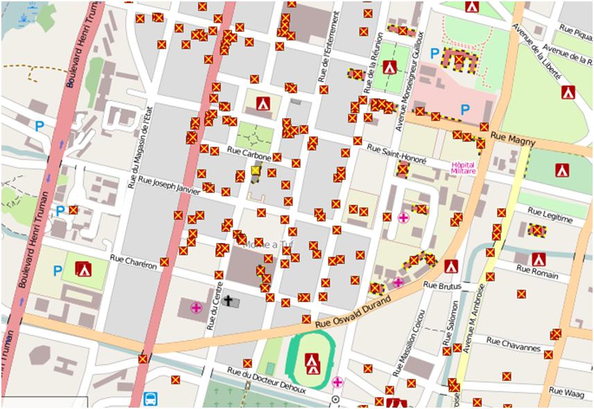
Figure 1: Example zoomed in area of former Haiti renderer on openstreetmap.nl. The Haiti custom rendering set up by User:Ldp which shows damaged buildings and refugee camps mapped within OpenStreetMap using specialGeoEye/DigitalGlobe imagery.
OSM also played a significant role in the Ebola virus epidemic in West Africa. Locations of roads, towns and buildings was unknown. There was an immediate need for geospatial data and maps.
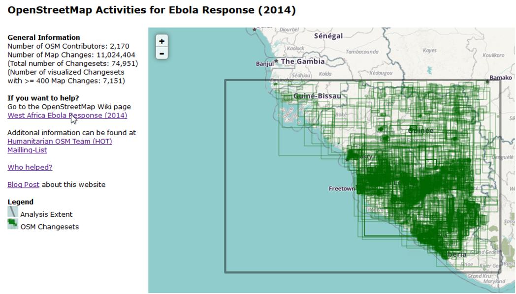
Figure 2: Pascal Neis Map showing OpenStreetMap activities during West Africa Ebola Outbreak
We are witnessing a shift in how geographic information is created and shared with contributions from passionate communities. Transparency and movement in collaboration is expanding as shown by National Geospatial Agency (NGA) teaming with Digital Globe, ESRI and OSM supporting disaster relief efforts in response to the Ebola epidemic in Western Africa (2014) and the Nepal earthquake (2015).
For the Ebola epidemic, NGA used ESRI’s ArcGIS Online, OpenStreetMap foundational data and DigitalGlobe commercial imagery and human geography data sets to provide a public website with 500 data layers, more than 200 products and about 70 applications. The website was viewed more than one million times over the period of October 2014 to February 2015.
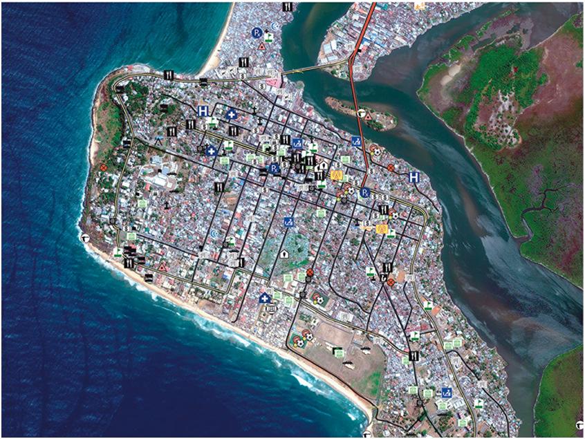
Figure 3: A DigitalGlobe WorldView-2 satellite image ofMonrovia, Liberia, taken April 8, 2014, is overlaid with DigitalGlobe Landscape+Human features. Photo Credit: DigitalGlobe
NGA followed its Ebola response method by launching a public website to assist with relief efforts the day after Nepal was struck by a devastating earthquake on April 25, 2015. The Nepal site hosts unclassified GEOINT data, products, and services. DigitalGlobe made its high-resolution satellite imagery available online. Volunteers tagged damaged buildings, roads, and other areas of major destruction using DigitalGlobe’s Tomnod crowdsourcing platform. In addition to the offerings that DigitalGlobe has made available, DigitalGlobe and NV5 Geospatial put their new partnership to good use with Amazon instances that allowed free access to the data and ENVI image analysis software for anyone that wanted to lend their image analysis skills to generate useful products for response and recovery efforts.
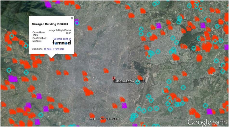
Figure 4: Photo Courtesy of Digital Globe The Tomnod team has released a Nepal earthquake data portal with a dynamic map of the latest crowdsourcing results.
Big Data
DigitalGlobe’s partnerships and recent effort to open source MrGeo is making it easier for data scientists and engineers to apply their expertise on spatial data. Crowdsourcing is moving to the next level beyond crisis mapping to big data analytics. In June, DigitalGlobe partnered with the United States Geospatial Intelligence Foundation (USGIF) to co-sponsor the first GEOINT-focused Hackathon.
Participants were requested to apply their expertise to DigitalGlobe Geospatial Big Data to create an open-source solution. There were two goals that participants were tasked with: (1) Expose their team’s thinking and build in hooks so another team working with another geography or outbreak could modify the solution to a new set of conditions and (2) determine why certain areas of West Africa were unaffected by the Ebola outbreak and predict where additional outbreaks might occur.
DigitalGlobe made available their imagery, human geography, elevation data, geospatial social media, and OpenStreetMap features available via a set of open APIs. The first place team’s solution focused on travel and revealed an “Ebola superhighway” along the coast of West Africa.
On the horizon
The crowd source community and collaboration analyzing massive amounts of distributed data to draw insights about a situation can result in increased productivity and innovation. Tapping into this collective intelligence results in diverse perspectives that are critical factors to moving innovation further, faster.
I suspect we will see more crowdsource problem solving as large amounts of globally distributed data continue to grow at a rapid rate and look forward to the collaboration solving tough, real-world problems.