ENVI Analytics Enable Consultants to Meet Environmental Standards
Environmental consultants are often tasked with helping clients comply with environmental regulations—whether it is monitoring air quality or ensuring that construction sites are located outside of designated wetlands, just to name a couple.
For example, mining companies often work closely with consultants to plan potential sites, to reduce operational impacts to the environment, and to reintroduce natural vegetation to the landscape when mines are decommissioned. Having access to regular aerial surveys can ensure that environmental regulations are being met throughout the life cycle of a mining project. During the last decade, consultants have been relying more on aerial photography and near-real time UAV imagery for continuous monitoring of mining and development projects.
Land-use classification of aerial images is an effective tool for surveying primary land-cover types (such as water, vegetation and disturbed earth) at a given point in time. When two co-registered classification images from different dates are compared with each other, their differences can be presented as a change detection map.
This article shows some examples of how consultants can use aerial imagery of a surface mining site to monitor changes to disturbed earth over a two-year period. Similar methods can also be used to monitor vegetation changes over time as part of site remediation.
In lieu of using proprietary UAV data for illustration, the examples in this article use public-domain NAIP imagery, as similar analytic methods apply. The U.S. Department of Agriculture National Agricultural Imagery Program (NAIP) acquires aerial imagery every two to three years at 1-meter resolution over the United States during the agricultural growing season.
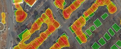
This figure shows a true-color NAIP image subset from October 18, 2015 of a large-scale mining project in Minnesota.
To create a land-use class called "Disturbed Earth," ENVI software was used to create a blue-to-NIR ratio image. Brighter pixels indicate areas devoid of any vegetation, where man-made activity has occurred.
Pixel values above a threshold of 0.48 were converted to a region of interest (ROI), which was then exported to a classification image. The same process was repeated for the 2017 NAIP image. Here are the results, which reveal differences in the amount of disturbed earth over two years:
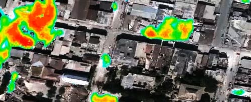
From this view, the differences can be hard to interpret. A change detection map created with the ENVI Thematic Change tool provides a better view of which areas have changed over time:
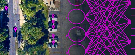
The ENVI Deep Learning module can help locate other groups of tailings like these throughout an entire site. While training a deep learning model can take some time, it only needs to be trained once. Then it can be applied multiple times to find similar features in other images.
The examples below show how a deep learning model accurately located other tailing piles in a different image than it was trained on:
Supervised classification and machine-learning methods are preferred for defining broad categories of land-use classes; however, extracting more detailed features of interest requires a different approach.
Deep learning is an emerging technology that shows great promise in helping analysts locate more complex features such as waste piles, settling ponds, and haul roads in a mining site. The following image shows a group of tailings, which are piles of sediment left over after ore is extracted from excavation:
The boundaries of these features can be easily exported to a shapefile for GIS analysis and for determining their total area.
Analysts can also use the ENVI Modeler to create and run custom deep-learning and classification workflows for future studies. By using ENVI's suite of deep learning and classification tools, environmental consultants can provide accurate and trusted answers for their clients, particularly when it comes to meeting environmental standards for large-scale mining and development projects.
Do you have a complicated problem you think ENVI Analytics or ENVI Deep Learning might be able to solve? If so, our experts will help you solve it! Email us at GeospatialInfo@NV5.com and we'll discuss your project with you.
SHORT DEMO VIDEO
Real-time, actionable intelligence to relief organizations responding to a natural disaster.
BLOG ARTICLE
See how ENVI Deep Learning can drastically reduce labeling and training time.
RECORDED WEBINAR
Learn about our ENVI Deep Learning module and its benefits over other technologies.