Remote Sensing of Light Pollution Near U.S. National Parks
Anonym
With the 100th anniversary of the U.S. National Park Service in 2016, I have been wanting to get out and visit more national parks this year. A few weeks ago I spent some time in Great Basin National Park. Its remote location provided the bluest sky I had ever seen and a rare chance to see the Milky Way and thousands of bright stars.
Sadly, the ability to view clear night skies in the way that our ancestors did is becoming a rare commodity as air and light pollution increase. In this article I will talk briefly about light pollution specifically, and how we can use remote sensing to see its effects on a large geographic scale. I will show how I used ENVI to map national park boundaries relative to nearby light sources detected from satellite imagery.
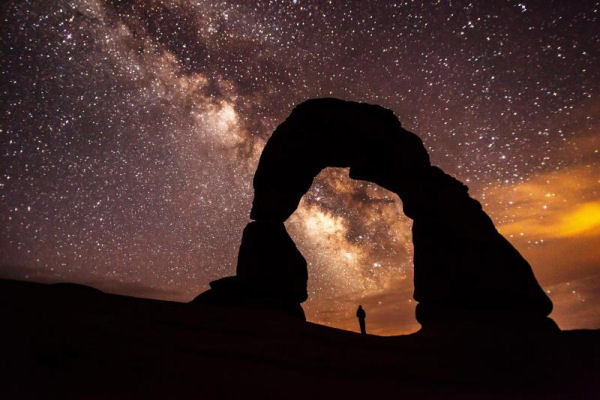
National Park Service photo / Jacob W. Frank
Light pollution is an excessive brightening of the night sky caused by artificial light that emits upwards or sideways. Air pollution particles also increase the scattering of light at night. If you live in a big city like I do, it is difficult to pick out even a few stars at night. Throughout the last few decades, light pollution has encroached upon remote lands, including national parks. As this National Park Service web site explains, starry skies are becoming an “endangered resource.”
Researchers have traditionally used sky quality meters and photodiode devices to measure night-sky illuminance in specific locations. However, in recent years, satellite cameras have been used to look downward at Earth to analyze the global effects of light pollution over time. From 1992 to 2012, the Defense Meteorological Satellite Program (DMSP) provided nighttime lights imagery. From 2012 to present, the Suomi-NPP Visible Infrared Imager Radiometer Suite (VIIRS) sensor has provided even more detailed imagery of night lights.
NPP VIIRS has a Day/Night Band (DNB) product that can detect lights, glas flares, auroras, and even wildfires from space. I used the NOAA CLASS website to download NPP VIIRS Near Constant Contrast (NCC) data, which is derived from the DNB product. DNB radiance values are converted to a reflectance-like value that offers a better visual interpretation of light sources at night.
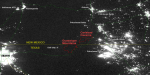
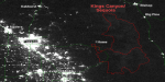
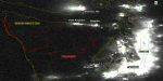
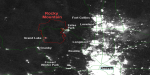
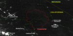
Here is a screen capture taken with ENVI 5.3 that shows NCC imagery along with a shapefile of national park boundaries (in red). I restricted the analysis to western continental U.S. parks:
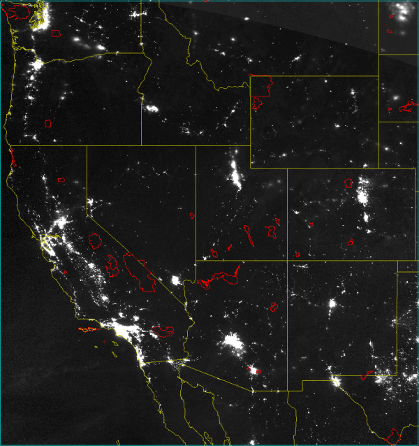
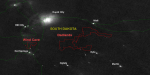
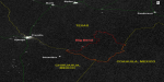
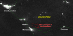
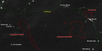
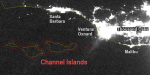
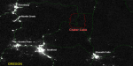
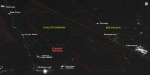
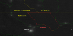
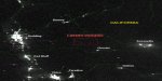
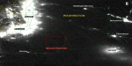
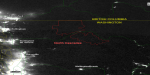
Click on the thumbnail images below to see each park in closer detail. I labeled major cities and petroleum sites in white. Major roads are colored green. Park boundaries are colored red. For comparison, the scale is the same among all the images (1:625,000), as well as the image stretch.
Badlands/Wind Cave |
Big Bend |
Black Canyon of the
Gunnison |
Capitol Reef/Arches/
Canyonlands |
Channel Islands |
Crater Lake |
Death Valley |
Glacier |
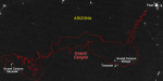
Grand Canyon |
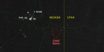
Great Basin |
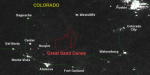
Great Sand Dunes |
Carlsbad Caverns/
Guadalupe Mountains |
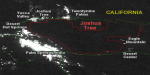
Joshua Tree |
Kings Canyon/Sequoia |
Lassen Volcanic |
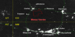
Mesa Verde |
Mount Rainier |
North Cascades |
Olympic |
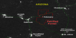
Petrified Forest |
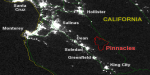
Pinnacles |
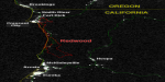
Redwood |
Rocky Mountain |
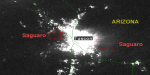
Saguaro |
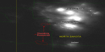
Theodore Roosevelt |
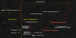
Teton/Yellowstone |
Yosemite |
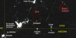
Zion/Bryce Canyon |
One thing you may notice is an absence of lights within park boundaries.The National Park Service has programs in place to preserve the natural lightscapes of the national parks. These efforts attempt to minimize the intrusion of artificial light into the ecosystems of parks.
From looking at these maps, you can see why some parks are better suited for viewing the night sky. They are far from populated areas:
- Arches
- Badlands
- Big Bend
- Bryce Canyon
- Canyonlands
- Capitol Reef
- Crater Lake
- Death Valley
- Glacier
- Grand Canyon
- Great Basin
- Yellowstone
Others are potentially affected by major sources of nearby light pollution:
- Carlsbad Caverns
- Channel Islands
- Guadalupe Mountains
- Pinnacles
- Saguaro
- Theodore Roosevelt
Satellite imagery gives us a unique perspective on viewing the effects of light pollution over time. To learn more about this subject, please see the resources below.
Resources
Davis, L., "10 Spectactular Parks for Stargazing." National Parks Conservation Association (2014). https://www.npca.org/articles/378-10-spectacular-parks-for-stargazing. Accessed April 2016.
“Night Skies.” National Park Service (2015). http://www.nature.nps.gov/night/index.cfm, Accessed April 2016.
“Remote Sensing with Nighttime Lights", Remote Sensing special issue, Vol. 7 (2015), C. Elvidge, editor.
The National Park Boundary dataset was provided by the Earth Data Analysis Center (EDAC), Resource Geographic Information System (RGIS), University of New Mexico. Data retrieved from https://www.data.gov/.