Using SAR to Map Damage From the Haiti Earthquake
Megan Gallagher
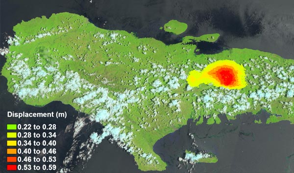
The Sentinel-1 sensor was used to collect SAR data for DinSAR analysis that was performed with the ENVI® SARscape Analytics Displacement Map workflow. Sentinel-2 Imagery is used as the background images.
A 7.2-magnitude earthquake struck southwestern Haiti on Saturday morning August 14, 2021, leaving at least 1,941 people dead and more than 6,900 injured. Casualties are expected to increase over the week as search and rescue continues. Those efforts are currently being complicated by heavy rains from Tropical Storm Grace and blocked roads in the region due to damaged infrastructure and mudslides.
Remotely sensed data can be a life-saving tool following a natural disaster to understand damage and map routes to deliver aid. However, when bad weather is either the cause or follows the event, getting a clear picture of the situation on the ground is difficult. In those situations, Synthetic Aperture Radar (SAR) sensors which capture data at night and see-through cloud cover, dust and smoke, can provide the information needed.
DinSAR analysis is commonly used after events such as earthquakes and volcanic eruptions to show land movement over time. With the surface changes measured at the meter scale, it’s evident that a tremendous amount of energy was released over a large area causing wide-spread destruction and damage to tens of thousands of homes, buildings and critical infrastructure.
The epicenter of Saturday’s earthquake was about 125 kilometers (78 miles) west of Haiti’s capital, Port-au-Prince. It hit just 11 years after a 7.0 magnitude quake that occurred closer to the densely populated Port-au-Prince, killing an estimated 220,000 to 300,000 people and destroying 100,000 buildings.
Earthquakes in Haiti can be extremely devastating due to it being in a seismically active area with a high population density and buildings designed to hold-up under hurricane-force winds and not earthquakes. Haiti is also prone to mudslides due to its mountainous topography and years of deforestation.
There are two versions of ENVI SARscape to make this data type accessible to everyone, regardless of their knowledge and background. With ENVI SARscape, you can process and analyze SAR data as well as integrate this information with other geospatial products. ENVI SARscape Analytics has straight forward workflows that streamline processing to deliver answers that only SAR data can provide.

HOT MESS EPISODE
Hot Mess: Remote Sensing Applications for Wildfires and Other Natural Disasters

RECORDED WEBINAR
Effectively Use Geospatial Data in the Disaster Management Cycle

SAR WEBINAR
Surface Motion Monitoring Using SAR Interferometric Techniques