Working with WorldView-3 SWIR Data in ENVI and New Horizon's View of Pluto
Exploiting Short Wave Infrared Data
Anonym
DigitalGlobe has been pushing the boundaries of commercially available satellite imagery for years, and the addition of the WorldView-3 sensor to their satellite constellation has image scientists giddy with excitement. Even though WorldView-3 has been airborne for nearly one year at this point (August 13, 2014 launch date) there is not much information on the web regarding the use of the SWIR bands, we hope to rectify that.
SWIR extends beyond the near-infrared region of the electromagnetic spectrum and refers to non-visible light falling roughly between 1400 and 3000 nanometers. The benefits of collecting reflectance data in these wavelengths are vast, including improved atmospheric transparency, snow and ice distinction, smoke penetration and the identification of man-made materials. For our purposes in this blog we will be highlighting how SWIR data allows an analyst to easily delineate between man-made materials, in our case materials used for roofing.
When you look at an image in true-color you are viewing what the human eye would see from a plane or a helicopter and this is great for spatial context. However, oftentimes the absorption features which define a material will only be apparent in the short wave infrared region of the electromagnetic spectrum, you cannot see these differences in true-color but a sensor collecting data beyond the visible range will detect these differences.
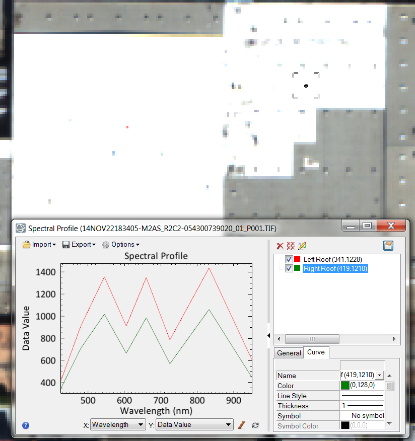
The image below was created with a true color composite of multispectral imagery provided by DigitalGlobe over Fullerton, California. With the MSI it appears as though our two rooftops are made of the same white material. Even when we display a spectral profile of the two rooftops it appears from the multispectral imagery that the pixels simply vary in brightness and contain similar absorption features. If only there was a way we could expand the extent of the x-axis to include more of the electromagnetic spectrum....
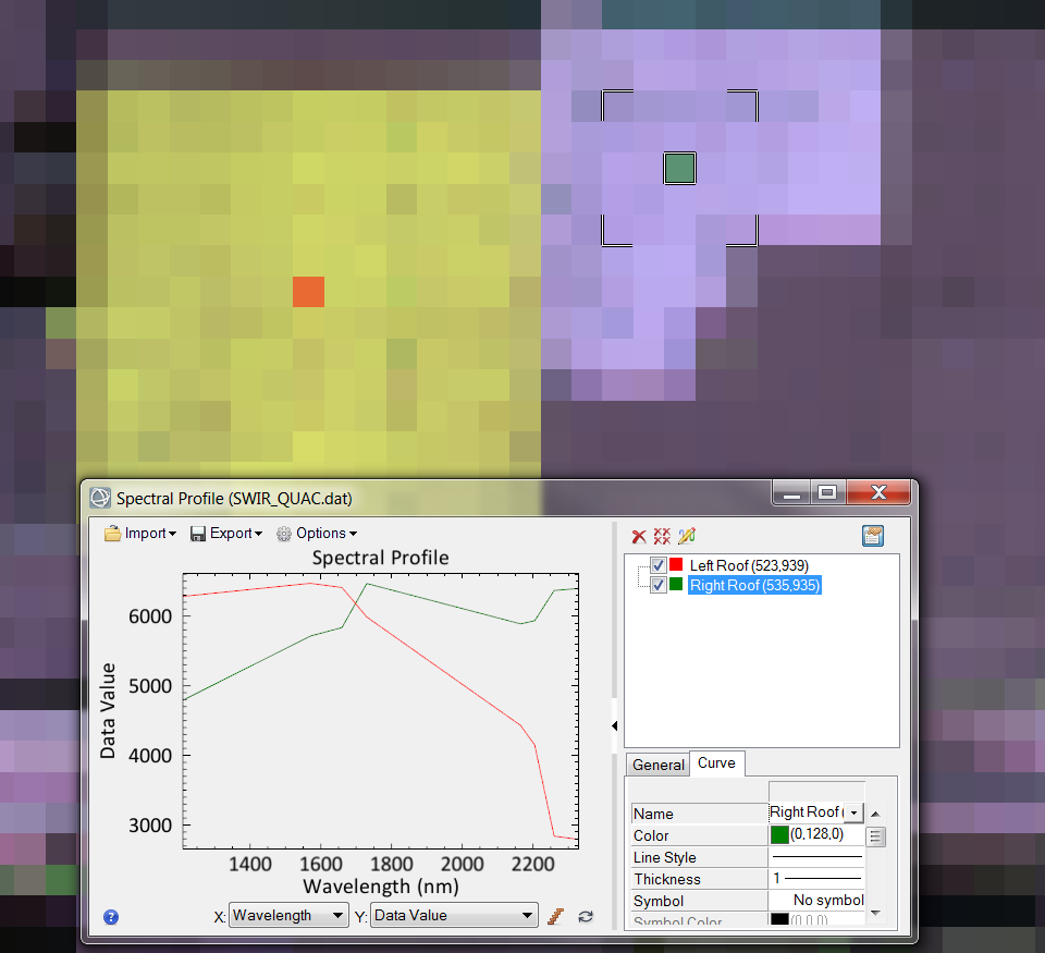
The image below is created by displaying SWIR 2 (1570 nm) as Red, SWIR 1 (1210 nm) as Blue and SWIR 8 (2330 nm) as Green, over the same extent as the image above. The pixel size is larger with SWIR data compared to MSI data, but the added coverage of the electromagnetic spectrum in the SWIR data makes up for the pixel size. The first apparent difference in the image below is that these two rooftops are very clearly different colors, and this is due to the different reflectance values seen in the currently displayed SWIR bands. The roof on the right appears purple because those pixels have high reflectance values in the bands being displayed as blue and red, SWIR 1 and SWIR 2 in our case. The roof on the left appears yellow because those pixels have high reflectance values in the bands being displayed as red and green, SWIR 2 and SWIR 8 in our case. The difference in reflectance values in the SWIR 1 band and the SWIR8 band is what is allowing us to view the difference in material-type for these rooftypes. Without a sensor that collects reflectance data beyond 1400 nanometers we would have difficulty identifying the differences in these materials. You can easily tell from the spectral plots of these two roofs that they are very different materials. If we only had the MSI data then we would not have the same spectral detail and thus have a more limited ability to delineate between these man-made materials.
SWIR data allows you to see what the human eye cannot. Oftentimes an object or feature will appear homogeneous with multispectral imagery, but with short wave infrared imagery the features are clearly different. The ability to augment your results by having data covering more of the electromagnetic spectrum will only help you to create better products down the road, and the ENVI suite of tools will help to exploit this added information.
To make this even more relevant many of the images we will be seeing of Pluto and its moons, collected by the New Horizons NASA mission, will be collected within the SWIR range of the electromagnetic spectrum. In fact the first detailed image released was a false-color composite created from SWIR bands which helped to show the presence of large methane-ice deposits on the surface of Pluto. For more information on this mission and how infrared imagery will lead the way in determining the chemical composition of Pluto and its moons go to the New Horizons page on the JHUAPL site.
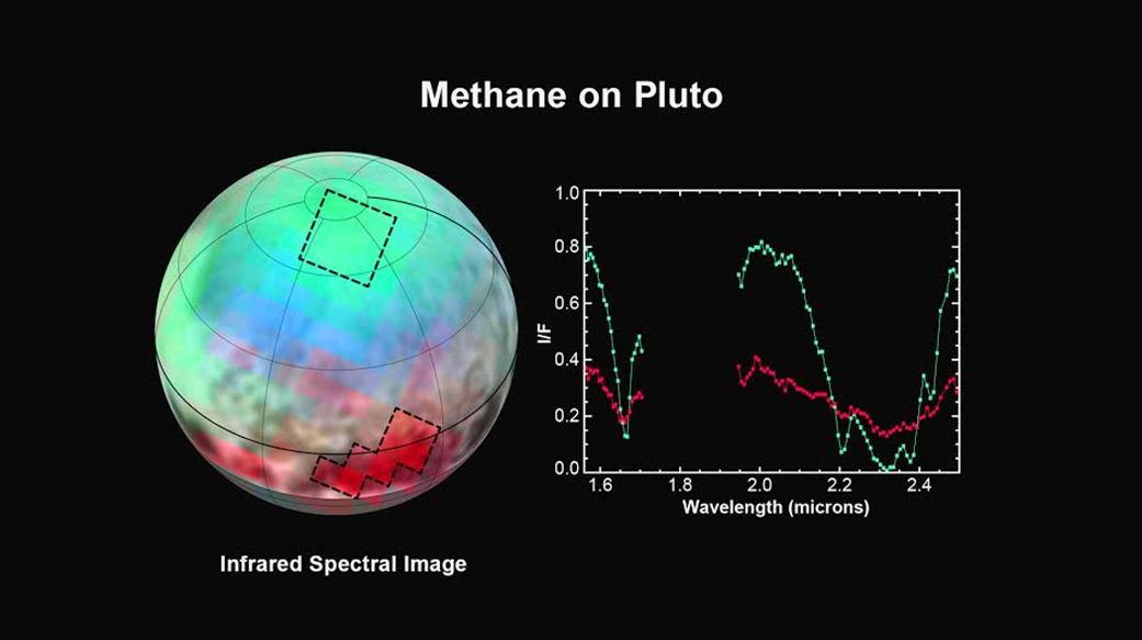
The figure above is courtesy of NASA-JHUAPL-SwRI