X

NV5 Geospatial Blog

Each month, NV5 Geospatial posts new blog content across a variety of categories. Browse our latest posts below to learn about important geospatial information or use the search bar to find a specific topic or author. Stay informed of the latest blog posts, events, and technologies by joining our email list!


NV5 at ESA’s Living Planet Symposium 2025

NV5 at ESA’s Living Planet Symposium 2025

9/16/2025

We recently presented three cutting-edge research posters at the ESA Living Planet Symposium 2025 in Vienna, showcasing how NV5 technology and the ENVI® Ecosystem support innovation across ocean monitoring, mineral exploration, and disaster management. Explore each topic below and access the full posters to learn... Read More >

Monitor, Measure & Mitigate: Integrated Solutions for Geohazard Risk

Monitor, Measure & Mitigate: Integrated Solutions for Geohazard Risk

9/8/2025

Geohazards such as slope instability, erosion, settlement, or seepage pose ongoing risks to critical infrastructure. Roads, railways, pipelines, and utility corridors are especially vulnerable to these natural and human-influenced processes, which can evolve silently until sudden failure occurs. Traditional ground surveys provide only periodic... Read More >

Geo Sessions 2025: Geospatial Vision Beyond the Map

Geo Sessions 2025: Geospatial Vision Beyond the Map

8/5/2025

Lidar, SAR, and Spectral: Geospatial Innovation on the Horizon Last year, Geo Sessions brought together over 5,300 registrants from 159 countries, with attendees representing education, government agencies, consulting, and top geospatial companies like Esri, NOAA, Airbus, Planet, and USGS. At this year's Geo Sessions, NV5 is... Read More >

Not All Supernovae Are Created Equal: Rethinking the Universe’s Measuring Tools

Not All Supernovae Are Created Equal: Rethinking the Universe’s Measuring Tools

6/3/2025

Rethinking the Reliability of Type 1a Supernovae   How do astronomers measure the universe? It all starts with distance. From gauging the size of a galaxy to calculating how fast the universe is expanding, measuring cosmic distances is essential to understanding everything in the sky. For nearby stars, astronomers use... Read More >

Using LLMs To Research Remote Sensing Software: Helpful, but Incomplete

Using LLMs To Research Remote Sensing Software: Helpful, but Incomplete

5/26/2025

Whether you’re new to remote sensing or a seasoned expert, there is no doubt that large language models (LLMs) like OpenAI’s ChatGPT or Google’s Gemini can be incredibly useful in many aspects of research. From exploring the electromagnetic spectrum to creating object detection models using the latest deep learning... Read More >

1345678910Last
«September 2025»
SunMonTueWedThuFriSat
31123456
78910111213
14151617181920
21222324252627
2829301234
567891011
15456 Rate this article:
4.0

3D Point-Cloud Generation from Stereo Imagery

Anonym

One of the most exciting new software technologies we will release this summer in concert with ENVI 5.3 is the ability to generate 3D point-clouds using stereo optical imagery from some of the more popular commercial spaceborne platforms (e.g. WorldView-3 and Pléiades-1). This functionality will be a new component of the upcoming ENVI Photogrammetry Module that will produce LAS format output files that can be used with ENVI's wide variety of point-cloud visualization & processing tools including raster DSM creation, 3D feature extraction and line-of-sight analysis.
 
This software technology generates 3D point-clouds from spaceborne EO/IR imaging platforms via multi-ray photogrammetry techniques that involve feature detector pixel correlation and dense image matching. This will allow users to take advantage of existing large commercial imagery archives to generate 3D point-clouds and create terrain products in regions where flying airborne LiDAR collections are not feasible or are cost prohibitive.
 
One of the testing datasets we are utilizing as we develop this software technology is the "Pléiades TRISTEREO" sample dataset available on the Airbus Defence & Space - Sample Imagery website. This tri-stereo dataset is located in Melbourne, Australia and below is a screenshot of an image subset with the Flemington Racecourse:
 

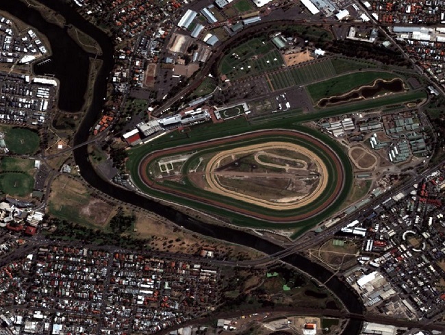
Image data courtesy of Airbus Defence and Space

 
From the three input Pléiades-1 images the rational polynomial coefficient (RPC) metadata is used along with a block adjustment process to generate a 3D point-cloud. Below is a screenshot of the derived point-cloud colored by height and shaded by intensity from the input imagery loaded into the ENVI software:
 

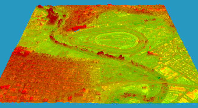
3D point-cloud generated by ENVI Photogrammetry Module
Please login or register to post comments.