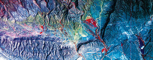
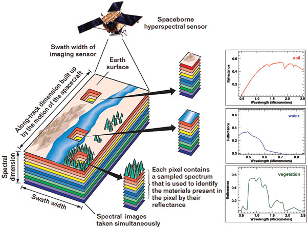
For those charged with protecting our national security, the challenge of mission readiness today begins with more and better intelligence. One of the emerging sources of this intelligence is hyperspectral remote sensing. Like its multispectral counterpart, hyperspectral sensing lets us "see" beyond the few colors the human eye can perceive. But while multispectral sensors typically sense only a few, broad wavelength bands, such as blue, green, red, and near-Infrared, hyperspectral sensors capture hundreds of very narrow bands, providing an unmatched level of detail.
This higher level of spectral detail lets analysts find and interpret what we might sometimes call "the unseen." Every object or material—whether solid, liquid, or gas—reflects or emits electromagnetic energy in a distinctive way. Hyperspectral sensing enables one to exploit these distinctive spectral characteristics to derive valuable intelligence that would be difficult or impossible to obtain any other way.
ANSWERING IMPORTANT QUESTIONS
By exploiting the telltale spectral signatures of materials, hyperspectral data can be used to answer important questions, such as:
Is a specific material in the scene (detection)? For instance, a pipeline operator would want to know if any methane is present along a natural gas pipeline, indicating a leak. Detection typically relies on signature-matching techniques, such as spectral matched filtering against known reference spectra.
What materials are present in the scene and where (classification)? An application might be the mapping of soil types to determine the trafficability of an area or the location of disturbed earth as an indication of construction activity. Classification often relies on "fitting" approaches, in which we take a measured spectrum and then look for a combination of reference spectral data that resemble it.
How much of the material is present (quantification)? Quantification is often performed in conjunction with detection and classification. In the methane leak example, users would benefit from knowing how much methane is being emitted, as well as its presence. In another example, measuring the amount of chlorophyll in a water body can indicate the quantity of algae present, thus providing insight into water quality.
These uses of hyperspectral sensing—detection, classification, and quantification—can address a multitude of commercial, civil, Department of Defense, and Intelligence Community needs. While applications are numerous and varied, a few include:
- Natural resource identification and environmental impact assessment
- Exploration and remediation for petroleum and mining industries
- Monitoring of greenhouse gas emissions from power plants and other industrial facilities
- Water quality measurement and source monitoring (including glaciers)
- Measurement of temperature and humidity distributions in the atmosphere to support weather modeling
- Detection, tracking, and monitoring of targets of interest and nefarious activities, such as narcotics manufacturing
- Evaluation of farm crop seasonal progress and crop stress
EXPANDING APPLICATIONS
Over the last decade, hyperspectral imaging has made the leap from an experimental to an operational capability with the maturation of ground-, air-, and space-based sensors, as well as in processing capabilities. As a provider of commercial and custom hyperspectral processing and exploitation software and hyperspectral sensors, NV5 sees two major trends developing.
First, we believe that constellations of low-cost smallsats with hyperspectral payloads will become commonplace. Several commercial ventures are planning to launch hyperspectral smallsats in the coming years. Eventually, these systems will also include on-board processing to provide timely results to those who need them.
Secondly, as such systems become widely available, we expect to see an explosion of hyperspectral-derived analytics, which allow users to derive significantly more valuable information from the data. Machine learning-based analytics could, for example, detect the onset of deteriorating water quality or crop damage due to pests or disease much quicker than done today.
SUPPORTING PROACTIVE MISSION READINESS
Multi-intelligence (multi-INT) analyses—the fusing together of collections from different sensing sources to extract new levels of intelligence—represent an important path toward more comprehensive and effective situational awareness. With its material detection and identification capability, hyperspectral imaging can play an important role in tomorrow's multi-INT products.
Consider an airborne platform that hosts both a wide-area motion imaging (WAMI) and signal intelligence (SIGINT) sensor used to detect and track the cell phone signal of a suspected attacker. The SIGINT sensor locates the cell phone signal, cross-cues to the WAMI sensor, which then starts to track the signal's movement across a region. As the suspected attacker stops at locations along the route, a hyperspectral system is queued to scan against a list of "targets of interest" at each location. This type of multi-INT capability is not just powerful, it is lifesaving.
As part of a multi-INT solution or alone, hyperspectral imaging has the ability to deliver new levels of intelligence to support proactive mission readiness. And readiness, as part of a comprehensive approach to resiliency, will help us meet the challenges of mobile and increasingly capable adversaries.