X

NV5 Geospatial Blog

Each month, NV5 Geospatial posts new blog content across a variety of categories. Browse our latest posts below to learn about important geospatial information or use the search bar to find a specific topic or author. Stay informed of the latest blog posts, events, and technologies by joining our email list!


Deploy, Share, Repeat: AI Meets the Analytics Repository

Deploy, Share, Repeat: AI Meets the Analytics Repository

10/13/2025

The upcoming release of ENVI® Deep Learning 4.0 makes it easier than ever to import, deploy, and share AI models, including industry-standard ONNX models, using the integrated Analytics Repository. Whether you're building deep learning models in PyTorch, TensorFlow, or using ENVI’s native model creation tools, ENVI... Read More >

Blazing a trail: SaraniaSat-led Team Shapes the Future of Space-Based Analytics

Blazing a trail: SaraniaSat-led Team Shapes the Future of Space-Based Analytics

10/13/2025

On July 24, 2025, a unique international partnership of SaraniaSat, NV5 Geospatial Software, BruhnBruhn Innovation (BBI), Netnod, and Hewlett Packard Enterprise (HPE) achieved something unprecedented: a true demonstration of cloud-native computing onboard the International Space Station (ISS) (Fig. 1). Figure 1. Hewlett... Read More >

NV5 at ESA’s Living Planet Symposium 2025

NV5 at ESA’s Living Planet Symposium 2025

9/16/2025

We recently presented three cutting-edge research posters at the ESA Living Planet Symposium 2025 in Vienna, showcasing how NV5 technology and the ENVI® Ecosystem support innovation across ocean monitoring, mineral exploration, and disaster management. Explore each topic below and access the full posters to learn... Read More >

Monitor, Measure & Mitigate: Integrated Solutions for Geohazard Risk

Monitor, Measure & Mitigate: Integrated Solutions for Geohazard Risk

9/8/2025

Geohazards such as slope instability, erosion, settlement, or seepage pose ongoing risks to critical infrastructure. Roads, railways, pipelines, and utility corridors are especially vulnerable to these natural and human-influenced processes, which can evolve silently until sudden failure occurs. Traditional ground surveys provide only periodic... Read More >

Geo Sessions 2025: Geospatial Vision Beyond the Map

Geo Sessions 2025: Geospatial Vision Beyond the Map

8/5/2025

Lidar, SAR, and Spectral: Geospatial Innovation on the Horizon Last year, Geo Sessions brought together over 5,300 registrants from 159 countries, with attendees representing education, government agencies, consulting, and top geospatial companies like Esri, NOAA, Airbus, Planet, and USGS. At this year's Geo Sessions, NV5 is... Read More >

1345678910Last
«October 2025»
SunMonTueWedThuFriSat
2829301234
567891011
12131415161718
19202122232425
2627282930311
2345678
18638 Rate this article:
4.3

Basics of Map Coordinate Systems

A brief discussion about a few of the basic terms and elements of geodesy, cartography and coordinate systems

Anonym

Geodesy: The scientific discipline that deals with the measurement and representation of the Earth.

Cartography: The study and practice of making maps.

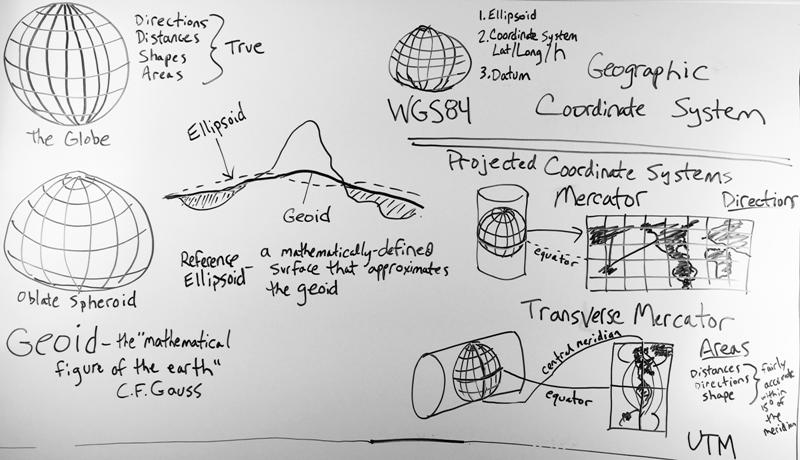
Geoid: C.F. Gauss, who first described it, called it the “mathematical figure of the Earth”. It is a smooth but highly irregular surface that can be derived only through extensive gravitational measurements and calculations. This gravity-defined equipotential surface theoretically would coincide with the mean ocean surface of the Earth, if the oceans and atmosphere were in equilibrium, at rest relative to the rotating Earth, and the seas extended through the continents (such as with a series of very narrow canals). The geoid is a much closer approximation of the true shape of the Earth than any reference ellipsoid could provide.

Reference Ellipsoid: A mathematically-defined surface that approximates the geoid. Because it is an idealized model of relative simplicity,reference ellipsoids are used as a preferred surface on which geodetic network computations are performed and point coordinates such as latitude, longitude and elevation are defined.

Datum: A datum is needed to be able to match coordinates on the reference surface to points on the physical surface of the Earth. It contains the specific definition of the reference surface as well as the point of origin and directions from that origin in order to specify the orientation of the surface.

Map Projection: A systematic transformation of a coordinate system defined on a three-dimensional reference surface such as a sphere or ellipsoid into coordinate locations on a two-dimensional plane. A  projection provides the transformation between a geographic coordinate system and a flat, planar projected coordinate system, the kind found on maps.

WGS 84: The latest revision of the World Geodetic System, a standard for use in cartography, geodesy and navigation. It is made up of a standard coordinate system for the Earth, a standard reference ellipsoid with datum. The geoid serves to define the nominal sea level. The coordinates used are latitude and longitude on the surface of the ellipsoid, and a height or Z value which defines the vertical displacement above or below the geoid.

UTM: A standard coordinate system which divides the Earth between 80 degrees South and 84 degrees North latitude into sixty zones, each six-degrees of longitude wide. It uses a transverse Mercator projection and, unlike WGS 84, is a 2-dimensional Cartesian system that specifies locations on the earth in terms of East and North coordinates independent of any vertical position.


Please login or register to post comments.