X

NV5 Geospatial Blog

Each month, NV5 Geospatial posts new blog content across a variety of categories. Browse our latest posts below to learn about important geospatial information or use the search bar to find a specific topic or author. Stay informed of the latest blog posts, events, and technologies by joining our email list!


New ENVI Agent, IDL Agent, and GeoAgent Quick Guides

New ENVI Agent, IDL Agent, and GeoAgent Quick Guides

6/9/2026

The recent release of ENVI® Agent, IDL® Agent, and GeoAgent™ revolutionize how users interact with geospatial software. These agentic AI applications act as partners to plan, simplify, and execute complex workflows. Knowing where to start can be challenging for new users. To this end, we developed three new quick guides to... Read More >

Introducing NISAR Data Support

Introducing NISAR Data Support

6/5/2026

The release of ENVI® SARscape 6.3 in April 2026 includes preliminary support for NASA-ISRO SAR (NISAR) data. The NISAR mission is a joint Earth-observing satellite project between NASA and the Indian Space Research Organization designed to monitor changes in the planet’s land and ice surfaces using advanced radar imaging. It... Read More >

Monitoring Illegal Mining in the Amazon: Turning Persistent Data Into Actionable Insight

Monitoring Illegal Mining in the Amazon: Turning Persistent Data Into Actionable Insight

5/28/2026

Illegal mining over decades has constituted one of the most persistent and complex socio-environmental problems in the Brazilian Amazon. In recent years, with the increasingly intensive use of mechanized extraction, the associated environmental impacts—such as deforestation, intense soil disturbance, river siltation, and mercury... Read More >

From Answers to Action: Why ENVI and IDL Agents Go Beyond General AI

From Answers to Action: Why ENVI and IDL Agents Go Beyond General AI

4/20/2026

As generative AI tools like Claude and Gemini continue to gain traction, many organizations are asking the same question: Can general purpose AI actually support real geospatial workflows, or does it stop at surface-level answers? That question was front and center in our recent webinar, Meet Your New Partners in Science: ENVI... Read More >

Mapping Earthquake Deformation in Taiwan With ENVI

Mapping Earthquake Deformation in Taiwan With ENVI

12/15/2025

Unlocking Critical Insights With ENVI® Tools Taiwan sits at the junction of major tectonic plates and regularly experiences powerful earthquakes. Understanding how the ground moves during these events is essential for disaster preparedness, public safety, and building community resilience. But traditional approaches like field... Read More >

1345678910Last
«June 2026»
SunMonTueWedThuFriSat
31123456
78910111213
14151617181920
21222324252627
2829301234
567891011
21986 Rate this article:
4.0

Big Data Science with Climate Analytics-as-a-Service

NASA Center for Climate Simulation Demonstrates On-demand Analytic Processing for Climate Change Research

Anonym

As one might easily imagine, the Big Data domain of climate science has been faced with unprecedented growth. At the NASA Center for Climate Simulation (NCCS), data scientists carefully curate the Modern-Era Retrospective Analysis for Research and Applications (MERRA) data collection, a synthesis of more than thirty years of observational data integrated with numerical models that is of increasing importance to climate change research.


NCCS has set up MERRA Analytic Services (MERRA/AS) to perform analyses using the MapReduce parallel computing approach running on Hadoop technology. In order to integrate the capabilities of the system for practical use, the Climate Model Data Services (CDS) API has been provided to support web service access for consumer applications, basic instructions from a command line interface, and advanced programmatic capabilities through python development. The Climate Analytics-as-a-Service (CAaaS) technology stack can be deployed on local enterprise hardware or on the cloud.

 Climate models project 21st century global temperatures.

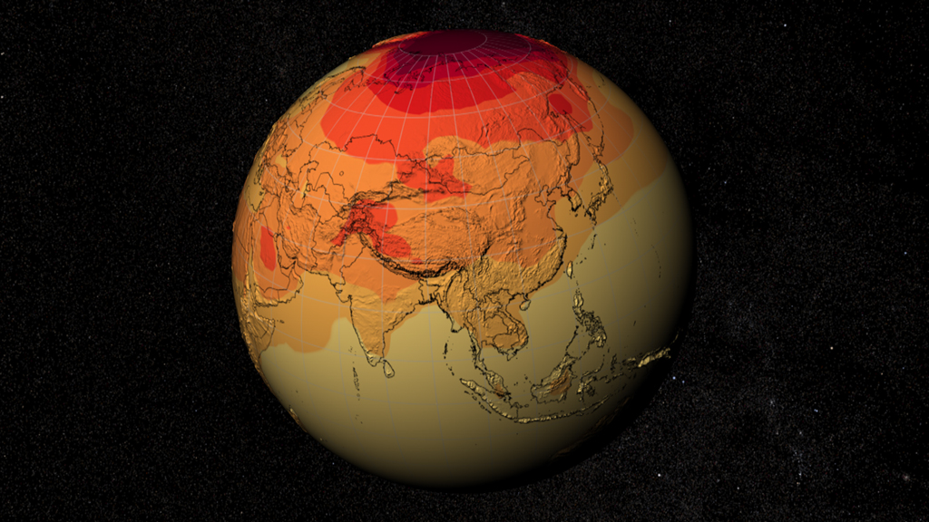
credit: NASA's Scientific Visualization Studio and NASA Center for Climate Simulation


MERRA spans across 160 terabytes, so it makes perfect sense that the analytical services are backed by some serious computational horsepower. In fact, the Hadoop MapReduce operations are running on a computing cluster powered by 36 Dell R710 servers, each with twelve 3 terabyte hard drives and an internal OS disc. Everything is connected through a 36-port InfiniBand switch and a 48-port Gigabit Ethernet switch. Overall, the cluster is capable of around 11 teraflops.


CAaaS provides a climate research specialization of the business-process-as-a-service concept, something that promises to continue gaining popularity as the cloud computational universe evolves. It provides capabilities which themselves demonstrate the power that such an approach may yield: high-performance and adaptive data proximal analytics, scalable data management, software as a virtualized appliance, and a generalized API that exposes reusable data services. NCSS's hope is that it will serve as a useful resource for developing and evaluating the next generation of climate data analysis tools and capabilities. With a promised reduction in the time spent in the preparation of data used to compare different data models – a long sought goal of the climate research community – MERRA/AS and CAaaS are a great real world example of Hadoop and MapReduce being used to drive experimental development of high-performance analytical applications in the climate science domain.

Please login or register to post comments.