X

NV5 Geospatial Blog

Each month, NV5 Geospatial posts new blog content across a variety of categories. Browse our latest posts below to learn about important geospatial information or use the search bar to find a specific topic or author. Stay informed of the latest blog posts, events, and technologies by joining our email list!


Not All Supernovae Are Created Equal: Rethinking the Universe’s Measuring Tools

Not All Supernovae Are Created Equal: Rethinking the Universe’s Measuring Tools

6/3/2025

Rethinking the Reliability of Type 1a Supernovae   How do astronomers measure the universe? It all starts with distance. From gauging the size of a galaxy to calculating how fast the universe is expanding, measuring cosmic distances is essential to understanding everything in the sky. For nearby stars, astronomers use... Read More >

Using LLMs To Research Remote Sensing Software: Helpful, but Incomplete

Using LLMs To Research Remote Sensing Software: Helpful, but Incomplete

5/26/2025

Whether you’re new to remote sensing or a seasoned expert, there is no doubt that large language models (LLMs) like OpenAI’s ChatGPT or Google’s Gemini can be incredibly useful in many aspects of research. From exploring the electromagnetic spectrum to creating object detection models using the latest deep learning... Read More >

From Image to Insight: How GEOINT Automation Is Changing the Speed of Decision-Making

From Image to Insight: How GEOINT Automation Is Changing the Speed of Decision-Making

4/28/2025

When every second counts, the ability to process geospatial data rapidly and accurately isn’t just helpful, it’s critical. Geospatial Intelligence (GEOINT) has always played a pivotal role in defense, security, and disaster response. But in high-tempo operations, traditional workflows are no longer fast enough. Analysts are... Read More >

Thermal Infrared Echoes: Illuminating the Last Gasp of a Dying Star

Thermal Infrared Echoes: Illuminating the Last Gasp of a Dying Star

4/24/2025

This blog was written by Eli Dwek, Emeritus, NASA Goddard Space Flight Center, Greenbelt, MD and Research Fellow, Center for Astrophysics, Harvard & Smithsonian, Cambridge, MA. It is the fifth blog in a series showcasing our IDL® Fellows program which supports passionate retired IDL users who may need support to continue their work... Read More >

A New Era of Hyperspectral Imaging with ENVI® and Wyvern’s Open Data Program

A New Era of Hyperspectral Imaging with ENVI® and Wyvern’s Open Data Program

2/25/2025

This blog was written in collaboration with Adam O’Connor from Wyvern.   As hyperspectral imaging (HSI) continues to grow in importance, access to high-quality satellite data is key to unlocking new insights in environmental monitoring, agriculture, forestry, mining, security, energy infrastructure management, and more.... Read More >

1345678910Last
13085 Rate this article:
5.0

Community Data Enrichment

Anonym

I love IMDB. I love being able to find movies that I am interested in, read a plot synopsis and then review the millions of reviews that the site houses. To me, those millions of reviews are where the value is, that is what keeps bringing me back to it. That value isn’t in its ability to aggregate widely available data, it is that they are taking this massive amount of data and then providing a platform for a community of highly interested users to enrich the experience for everyone. This enrichment comes through the reviewers sharing of a unique perspective, presenting ideas and interpretations of the movies through different optics than your own or simply telling you that Bruce Willis is a ghost in Sixth Sense and not marking **SPOILER ALERT** in the description.

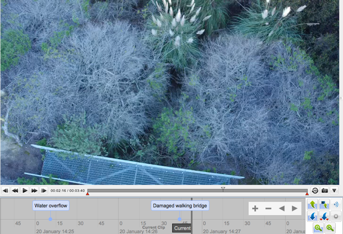
Image showing annotations in the Jagwire

I am writing about my love of IMDB not just because I love IMDB, but because the concept of data enrichment has been something that I have been a big advocate of within the NV5 Geospatial (formerly Harris) team for a while. With our Jagwire product, we had a great opportunity to lean forward and help drive the type of environment where we could enable this experience for our customers.

Most Unmanned Platforms (or “drones” for our non-Defense customers) have metadata that is available out of the box. This metadata (which can also include data from the sensor) typically is focused on providing spatial and temporal context (“where” was it and “when” was it there). This information is critical but, like IMDB, the ability to add community enriched data, (those user reviews in IMDB) to the geospatial products in Jagwire provides an unbelievable amount of value. Machine learning, automated image analytics and other technologies that help interpret objects, actions and even intent in data will continue to improve exponentially, but today nothing beats an analyst identifying an object as a “water tower” in an image or an engineer identifying damage to a utility pole after a storm. This enriched data is powerful. This type of data helps rapidly close the gap between “looking” for data and “taking action”.

The understanding of the value of this data is why Jagwire has so many entry points for our communities of users to share their understanding, expertise and perspective. Annotations, chat rooms and visual mark ups are a few examples of how Jagwire enables this type of interaction with the data. Over the next year we are going to continue to collaborate with our customers and partners in the Defense, Utility and Public Safety communities to expand in these areas within Jagwire. Our customers are continually challenging us to find ways to extract more value from their data and we are up to the challenge.

Please login or register to post comments.