X

NV5 Geospatial Blog

Each month, NV5 Geospatial posts new blog content across a variety of categories. Browse our latest posts below to learn about important geospatial information or use the search bar to find a specific topic or author. Stay informed of the latest blog posts, events, and technologies by joining our email list!


Mapping Earthquake Deformation in Taiwan With ENVI

Mapping Earthquake Deformation in Taiwan With ENVI

12/15/2025

Unlocking Critical Insights With ENVI® Tools Taiwan sits at the junction of major tectonic plates and regularly experiences powerful earthquakes. Understanding how the ground moves during these events is essential for disaster preparedness, public safety, and building community resilience. But traditional approaches like field... Read More >

Comparing Amplitude and Coherence Time Series With ICEYE US GTR Data and ENVI SARscape

Comparing Amplitude and Coherence Time Series With ICEYE US GTR Data and ENVI SARscape

12/3/2025

Large commercial SAR satellite constellations have opened a new era for persistent Earth monitoring, giving analysts the ability to move beyond simple two-image comparisons into robust time series analysis. By acquiring SAR data with near-identical geometry every 24 hours, Ground Track Repeat (GTR) missions minimize geometric decorrelation,... Read More >

Empowering D&I Analysts to Maximize the Value of SAR

Empowering D&I Analysts to Maximize the Value of SAR

12/1/2025

Defense and intelligence (D&I) analysts rely on high-resolution imagery with frequent revisit times to effectively monitor operational areas. While optical imagery is valuable, it faces limitations from cloud cover, smoke, and in some cases, infrequent revisit times. These challenges can hinder timely and accurate data collection and... Read More >

Easily Share Workflows With the Analytics Repository

Easily Share Workflows With the Analytics Repository

10/27/2025

With the recent release of ENVI® 6.2 and the Analytics Repository, it’s now easier than ever to create and share image processing workflows across your organization. With that in mind, we wrote this blog to: Introduce the Analytics Repository Describe how you can use ENVI’s interactive workflows to... Read More >

Deploy, Share, Repeat: AI Meets the Analytics Repository

Deploy, Share, Repeat: AI Meets the Analytics Repository

10/13/2025

The upcoming release of ENVI® Deep Learning 4.0 makes it easier than ever to import, deploy, and share AI models, including industry-standard ONNX models, using the integrated Analytics Repository. Whether you're building deep learning models in PyTorch, TensorFlow, or using ENVI’s native model creation tools, ENVI... Read More >

1345678910Last
15937 Rate this article:
4.0

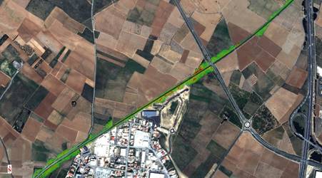
Utilizing free satellite imagery to focus maintenance efforts in rail corridors

Joey Griebel

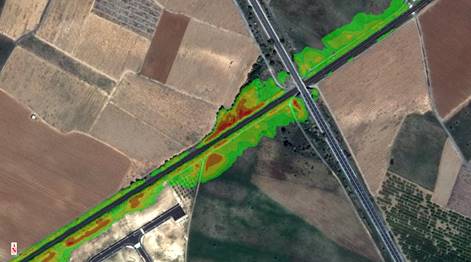
As sources of free satellite imagery like Sentinel-2 from ESA become more widely available, they will offer a unique ability to focus efforts for UAS collects and teams being fielded for maintenance efforts along rail corridors. Using the spectral information being collected by Sentinel-2 every 5 days and ENVI’s spectral analysis tools, those in charge of planning and scheduling the UAV and maintenance teams could put together a tipping and cuing system to focus their efforts. With Sentinel-2 flowing into S3 buckets on AWS, you could have your regions of interest along the rail corridor (or Utilities or Pipeline Corridor) and be continually running the automated vegetation hazard workflow our team has created and get alerts when a region has results of concern returned. The workflow calculates risk based upon vegetation health as well as the distance it is from the infrastructure focused on and returns an output similar to the image below.

                                                                                                                (Credit Alberto Meroni)

Being alerted to regions of concern, as opposed to having to fly thousands of miles with a UAS in sight to find those concerns allows the UAS data collection teams, as well the maintenance teams being dispatched to mitigate these concerns, to focus their efforts on a microlevel and get to additional concern areas faster.

While this example focused on running the workflow along a rail corridor, the same principle would apply along a utility corridor or along an oil and gas pipeline, which would come in handy in some of the remote and desolate stretches before sending boots out there to investigate. The analysis can be taken one step further, using time 1 results and time 2 results with ENVI’s image change workflow to allow those tasking to validate that the risk has been mitigated and the maintenance completed.

The use of freely satellite imagery will most likely never get to the level of resolution needed for most of these inspections, but what it does allow companies to quickly do is take that first pass of an area at macro scale and better plan their flights and how long they will be in an area.

Please login or register to post comments.