X

NV5 Geospatial Blog

Each month, NV5 Geospatial posts new blog content across a variety of categories. Browse our latest posts below to learn about important geospatial information or use the search bar to find a specific topic or author. Stay informed of the latest blog posts, events, and technologies by joining our email list!


New ENVI Agent, IDL Agent, and GeoAgent Quick Guides

New ENVI Agent, IDL Agent, and GeoAgent Quick Guides

6/9/2026

The recent release of ENVI® Agent, IDL® Agent, and GeoAgent™ revolutionize how users interact with geospatial software. These agentic AI applications act as partners to plan, simplify, and execute complex workflows. Knowing where to start can be challenging for new users. To this end, we developed three new quick guides to... Read More >

Introducing NISAR Data Support

Introducing NISAR Data Support

6/5/2026

The release of ENVI® SARscape 6.3 in April 2026 includes preliminary support for NASA-ISRO SAR (NISAR) data. The NISAR mission is a joint Earth-observing satellite project between NASA and the Indian Space Research Organization designed to monitor changes in the planet’s land and ice surfaces using advanced radar imaging. It... Read More >

Monitoring Illegal Mining in the Amazon: Turning Persistent Data Into Actionable Insight

Monitoring Illegal Mining in the Amazon: Turning Persistent Data Into Actionable Insight

5/28/2026

Illegal mining over decades has constituted one of the most persistent and complex socio-environmental problems in the Brazilian Amazon. In recent years, with the increasingly intensive use of mechanized extraction, the associated environmental impacts—such as deforestation, intense soil disturbance, river siltation, and mercury... Read More >

From Answers to Action: Why ENVI and IDL Agents Go Beyond General AI

From Answers to Action: Why ENVI and IDL Agents Go Beyond General AI

4/20/2026

As generative AI tools like Claude and Gemini continue to gain traction, many organizations are asking the same question: Can general purpose AI actually support real geospatial workflows, or does it stop at surface-level answers? That question was front and center in our recent webinar, Meet Your New Partners in Science: ENVI... Read More >

Mapping Earthquake Deformation in Taiwan With ENVI

Mapping Earthquake Deformation in Taiwan With ENVI

12/15/2025

Unlocking Critical Insights With ENVI® Tools Taiwan sits at the junction of major tectonic plates and regularly experiences powerful earthquakes. Understanding how the ground moves during these events is essential for disaster preparedness, public safety, and building community resilience. But traditional approaches like field... Read More >

1345678910Last
«June 2026»
SunMonTueWedThuFriSat
31123456
78910111213
14151617181920
21222324252627
2829301234
567891011
21550 Rate this article:
4.6

Helios Provides Free Access to Life-saving Technology During Hurricane Dorian

Erin Eckles

In September 2018, Hurricane Florence lashed North and South Carolina, bringing 13-foot storm surges and relentless rainfall. A year later as Hurricane Dorian left destruction behind in the Bahamas and took aim at the South Eastern shores of the US once again, meteorologists, emergency managers, and residents relied on Helios® technology (from ground to space) to prepare to protect their lives and property.

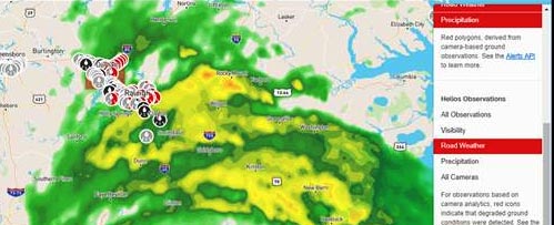
Before, during, and after both Hurricane Florence and Dorian, NV5 (formerly L3Harris) opened up its powerful Helios® real-time weather intelligence tool to allow more than 2,500 emergency managers, transportation officials, and residents free access to monitor the road conditions themselves. Helios uses machine learning to automatically filter through thousands of traffic and web cameras in the Helios network. During severe weather events, Helios boosts confidence in understanding ground conditions as it detects hazardous road conditions, such as pooling water. Helios improves the efficiency and effectiveness of disaster response and recovery, providing a unified operation picture to quickly deploy resources to the hardest hit areas.

We took a survey after the hurricanes to get feedback on how they used Helios. Here are the results:

More than 70% were satisfied with their experience using Helios 50% used it for business / 30% used it for personal / 20% used it for both Majority used Helios to:

  • Monitor Hurricane’s path/advance
  • Gain situational awareness of the storm
  • View weather and highway visibility
  • Manage road traffic and conditions
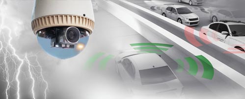
DISCOVER MORE

Fast, Accurate weather intelligence

Deep Learning Blog Post

HELIOS®

Fast and accurate local ground weather intelligence to enable real-time decision making.

Helios Proves To Be a Force Multiplier

BLOG ARTICLE

Helios was used by multiple agencies and businesses during hurricane florence.

ROAD WEATHER ANALYTICS CAN SAVE LIVES

Helios Weather Analytics

RECORDED WEBINAR

This webinar shows how Helios solves road weather challenges.


Please login or register to post comments.