X

NV5 Geospatial Blog

Each month, NV5 Geospatial posts new blog content across a variety of categories. Browse our latest posts below to learn about important geospatial information or use the search bar to find a specific topic or author. Stay informed of the latest blog posts, events, and technologies by joining our email list!


NV5 at ESA’s Living Planet Symposium 2025

NV5 at ESA’s Living Planet Symposium 2025

9/16/2025

We recently presented three cutting-edge research posters at the ESA Living Planet Symposium 2025 in Vienna, showcasing how NV5 technology and the ENVI® Ecosystem support innovation across ocean monitoring, mineral exploration, and disaster management. Explore each topic below and access the full posters to learn... Read More >

Monitor, Measure & Mitigate: Integrated Solutions for Geohazard Risk

Monitor, Measure & Mitigate: Integrated Solutions for Geohazard Risk

9/8/2025

Geohazards such as slope instability, erosion, settlement, or seepage pose ongoing risks to critical infrastructure. Roads, railways, pipelines, and utility corridors are especially vulnerable to these natural and human-influenced processes, which can evolve silently until sudden failure occurs. Traditional ground surveys provide only periodic... Read More >

Geo Sessions 2025: Geospatial Vision Beyond the Map

Geo Sessions 2025: Geospatial Vision Beyond the Map

8/5/2025

Lidar, SAR, and Spectral: Geospatial Innovation on the Horizon Last year, Geo Sessions brought together over 5,300 registrants from 159 countries, with attendees representing education, government agencies, consulting, and top geospatial companies like Esri, NOAA, Airbus, Planet, and USGS. At this year's Geo Sessions, NV5 is... Read More >

Not All Supernovae Are Created Equal: Rethinking the Universe’s Measuring Tools

Not All Supernovae Are Created Equal: Rethinking the Universe’s Measuring Tools

6/3/2025

Rethinking the Reliability of Type 1a Supernovae   How do astronomers measure the universe? It all starts with distance. From gauging the size of a galaxy to calculating how fast the universe is expanding, measuring cosmic distances is essential to understanding everything in the sky. For nearby stars, astronomers use... Read More >

Using LLMs To Research Remote Sensing Software: Helpful, but Incomplete

Using LLMs To Research Remote Sensing Software: Helpful, but Incomplete

5/26/2025

Whether you’re new to remote sensing or a seasoned expert, there is no doubt that large language models (LLMs) like OpenAI’s ChatGPT or Google’s Gemini can be incredibly useful in many aspects of research. From exploring the electromagnetic spectrum to creating object detection models using the latest deep learning... Read More >

1345678910Last
«September 2025»
SunMonTueWedThuFriSat
31123456
78910111213
14151617181920
21222324252627
2829301234
567891011
20219 Rate this article:
5.0

High Tech Ecology from the Air

Anonym

The other day I discovered a great TED talk by Greg Asner called "Ecology from the Air." Greg is an old grad-school colleague of mine, and is now at Stanford University and Carnegie Institution. Here at Exelis Greg is known as the brains behind ENVI's Vegetation Analysis tools. In his TED talk, Greg discusses ecological questions that can be addressed with his Carnegie Airborne Observatory (CAO), which includes a high-resolution imaging spectrometer integrated with a high resolution LiDAR sensor, mounted aboard an  aircraft with custom avionics.

The key innovation of the CAO is the integration of the state-of-the-art hyperspectral and LiDAR instruments. This integration does more than allow for fascinating data visualizations, although it also does that. The imaging spectrometer provides information about the chemistry of a vegetation canopy at the same time that the LiDAR instrument provides a detailed 3D representation of the canopy structure. This marriage of chemistry data and structure data in a geographic context has the power to completely change our understanding of ecosystems.

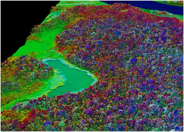
The Peruvian Amazon as seen by the Carnegie Airborne Observatory (CAO). Image courtesy of Carnegie Airborne Observatory (as published in New Scientist)

Greg goes on to note how important tropical forests are in terms of global ecology, and yet how little we really know about them, and asks, "How can we save what we don't understand?" He outlines three important questions about tropical forests that the CAO is well suited to address, and which are hard to answer from the ground or with conventional satellite imagery alone:

  1. How do we manage our carbon reserves in tropical forests? By which he seems to mean, "How do we keep the carbon in the forests,instead of releasing it to the atmosphere as greenhouse gases?"
  2. How do we prepare for climate change in a complicated,vast and largely remote place like the Amazon rainforest?
  3. How do we manage biodiversity in a planet of protected ecosystems? In other words, when much of the earth's biodiversity is preserved in heavily managed parks and preserves, how do we get the information that is critical for making decisions that preserve biodiversity?

What do you think of Greg's talk? Have you been inspired by imagery science you've seen in other TED talks? Leave a comment to let us know.

Please login or register to post comments.