Improving Crisis Response
Anonym
How well do you know your surroundings? Even if you have lived in one location for an extended period, every aspect of your immediate environment may not be as familiar to you as you think. Certain characteristics of your local area may pose risks to public safety and infrastructure, but may not be apparent until a natural disaster or unexpected event brings them to light. Although it is not feasible for an individual to be omniscient of every potential hazard present in a place, situational awareness provides an idea of what to expect. Geospatial data is an important source for situational awareness information, and can be an important resource to better understand the benefits and risks inherent to our surroundings.
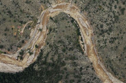
Road damage to Highway 34, east of Drake, Colorado
Image courtesy of the Colorado Wing of the United States Civil Air Patrol
Recent widespread flash floods in Colorado continue to affect towns along the Front Range of the Rocky Mountains and illustrate the value of situational awareness and preparedness. The flood risk posed by the mountainous topography nearby is not unfamiliar: public records chronicle disastrous flood events dating back to early Gold Rush settlements; and scoured canyon walls and other water-borne features evidence a history of flooding far more ancient. Yet, even with an understanding of local topography, an appreciation of what Mother Nature is capable of, and the expenditure of millions of dollars in flood mitigation infrastructure, local officials find themselves totally overwhelmed by the scale and intensity of a flooding event not seen in several generations.
Granted, it's nearly impossible to prepare for weather events of biblical proportions (as qualified by a National Weather Service bulletin), but the response to such a situation can be managed. State and local government agencies coordinating through offices of emergency management used tried and true methods to respond commendably as the Colorado flood crisis began unfolding. Notably, the efforts by Colorado National Guard units and the Federal Emergency Management Agency (FEMA) affected an evacuation response that surpassed that of Hurricane Katrina. The question after the response is, "could it have been conducted more quickly and accurately?" In other words, "is there an opportunity to learn something from the horrible events unfolding?" For someone who can appreciate the value geospatial data and analysis can bring to operational situational awareness, the answer is yes.
A geospatial perspective provides countless benefits for preparedness planning and post-flood disaster response: interpretation of remotely-sensed imagery for updated situational awareness; change detection of conditions to assess disaster impact and mitigation; spectral data analysis to delineate materials of interest; terrain modeling for mobility logistics and flood analysis, et cetera. These geospatial data types and analysis methodologies are proven under the dynamic and complex conditions of military operational settings. The challenge at hand is to fully integrate them into the operational playbooks of domestic disaster response agencies; to make geospatial analysis another tried and true method alongside the other definitive steps in the response protocol. Hopefully, in the near future standard operating procedures for disaster response will entail the use of all available remote sensing platforms, such as unmanned aerial vehicles (UAVs), to collect timely geospatial data, facilitate situational awareness, and respond more quickly and precisely in times of crisis.