X

NV5 Geospatial Blog

Each month, NV5 Geospatial posts new blog content across a variety of categories. Browse our latest posts below to learn about important geospatial information or use the search bar to find a specific topic or author. Stay informed of the latest blog posts, events, and technologies by joining our email list!


New ENVI Agent, IDL Agent, and GeoAgent Quick Guides

New ENVI Agent, IDL Agent, and GeoAgent Quick Guides

6/9/2026

The recent release of ENVI® Agent, IDL® Agent, and GeoAgent™ revolutionize how users interact with geospatial software. These agentic AI applications act as partners to plan, simplify, and execute complex workflows. Knowing where to start can be challenging for new users. To this end, we developed three new quick guides to... Read More >

Introducing NISAR Data Support

Introducing NISAR Data Support

6/5/2026

The release of ENVI® SARscape 6.3 in April 2026 includes preliminary support for NASA-ISRO SAR (NISAR) data. The NISAR mission is a joint Earth-observing satellite project between NASA and the Indian Space Research Organization designed to monitor changes in the planet’s land and ice surfaces using advanced radar imaging. It... Read More >

Monitoring Illegal Mining in the Amazon: Turning Persistent Data Into Actionable Insight

Monitoring Illegal Mining in the Amazon: Turning Persistent Data Into Actionable Insight

5/28/2026

Illegal mining over decades has constituted one of the most persistent and complex socio-environmental problems in the Brazilian Amazon. In recent years, with the increasingly intensive use of mechanized extraction, the associated environmental impacts—such as deforestation, intense soil disturbance, river siltation, and mercury... Read More >

From Answers to Action: Why ENVI and IDL Agents Go Beyond General AI

From Answers to Action: Why ENVI and IDL Agents Go Beyond General AI

4/20/2026

As generative AI tools like Claude and Gemini continue to gain traction, many organizations are asking the same question: Can general purpose AI actually support real geospatial workflows, or does it stop at surface-level answers? That question was front and center in our recent webinar, Meet Your New Partners in Science: ENVI... Read More >

Mapping Earthquake Deformation in Taiwan With ENVI

Mapping Earthquake Deformation in Taiwan With ENVI

12/15/2025

Unlocking Critical Insights With ENVI® Tools Taiwan sits at the junction of major tectonic plates and regularly experiences powerful earthquakes. Understanding how the ground moves during these events is essential for disaster preparedness, public safety, and building community resilience. But traditional approaches like field... Read More >

1345678910Last
«June 2026»
SunMonTueWedThuFriSat
31123456
78910111213
14151617181920
21222324252627
2829301234
567891011
23644 Rate this article:
5.0

Image Analysis: Now Part of Hollywood’s Story

Anonym

Fourteen years ago, prior to the start of the “Global War on Terror”, image analysis was rarely something you would see in a Hollywood production or PrimeTime TV show. Somewhere along the way, there was a turning point and the writers and producers realized the image analysis and intelligence piece helps tell the story. While some of us have known this goes on in the background and helps lead to the big decisions/missions we see in movies, most of the viewers do not.

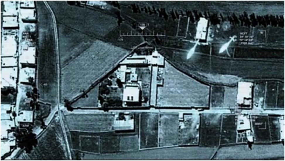
One of the first big movies I remember seeing this in was "Act of Valor" when a Raven UAV is launched and the Navy Seals are streaming a FMV (full motion video) feed and identifying targets prior to the raid. To the average person, that might seem like some sort of James Bond gadget, but to those in the field, it's known technology and a real capability. The next big Hollywood release that the intelligence piece caught my eye in was “Zero DarkThirty”, when the analysts are looking at the products created of Bin Laden’s compound and planning the raid. 3d models were then created from these products and later on it was learned that entire training compounds were modeled off of this information. Once the mission went live in the movie we saw the FMV/ drone feed again and POTUS watched a live stream as the Helo’s approached:

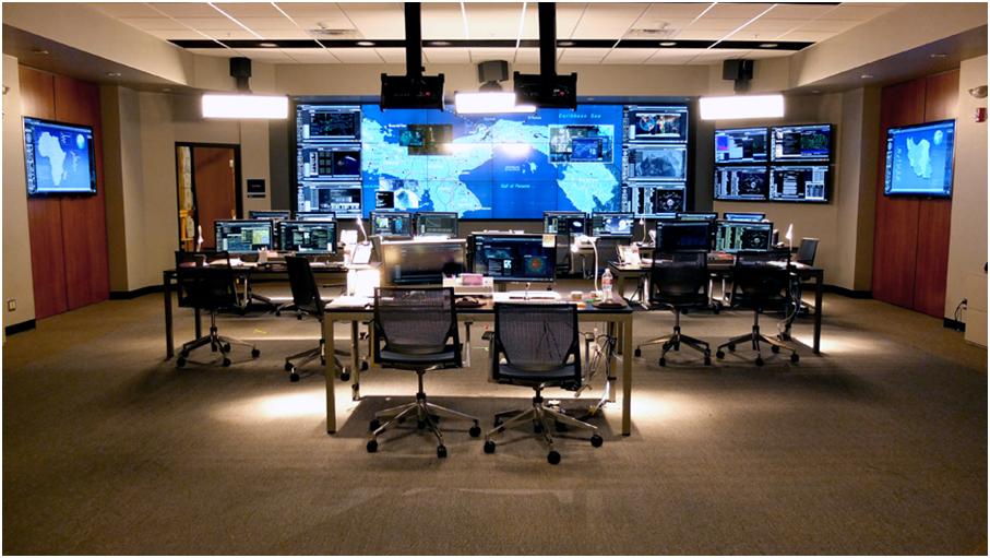
Fast forward to this year and “State of Affairs” had its first season launched. This show glamourized the intelligence field, and evenbrought in a small glimpse into weather monitoring. Almost every episode involves the intelligence opps room with a wide variety of analytics up from FMV feeds, weather feeds, IR images, and imagery of all sorts:


So why does any of this matter? While most of us have known for a while who work in or with the field, the value of image analytics and its role in stories that shape our world are finally getting the recognition and glory they deserve. The technology in the image analysis arena continues to grow and the possibilities are really becoming endless as to what you can track, detect, analyze, or really just watch. With the next gen technologies being flashed on TV shows and movies, I hope it plants a seed and starts to inspire the next generation who will really push the limits of our field and take the science that has formed what we know to the next level. Image analytics can be exciting and not only save lives, but save environments as a whole, and hopefully the more mainstream it becomes the further the envelope is pushed.  

Please login or register to post comments.