X

NV5 Geospatial Blog

Each month, NV5 Geospatial posts new blog content across a variety of categories. Browse our latest posts below to learn about important geospatial information or use the search bar to find a specific topic or author. Stay informed of the latest blog posts, events, and technologies by joining our email list!


Not All Supernovae Are Created Equal: Rethinking the Universe’s Measuring Tools

Not All Supernovae Are Created Equal: Rethinking the Universe’s Measuring Tools

6/3/2025

Rethinking the Reliability of Type 1a Supernovae   How do astronomers measure the universe? It all starts with distance. From gauging the size of a galaxy to calculating how fast the universe is expanding, measuring cosmic distances is essential to understanding everything in the sky. For nearby stars, astronomers use... Read More >

Using LLMs To Research Remote Sensing Software: Helpful, but Incomplete

Using LLMs To Research Remote Sensing Software: Helpful, but Incomplete

5/26/2025

Whether you’re new to remote sensing or a seasoned expert, there is no doubt that large language models (LLMs) like OpenAI’s ChatGPT or Google’s Gemini can be incredibly useful in many aspects of research. From exploring the electromagnetic spectrum to creating object detection models using the latest deep learning... Read More >

From Image to Insight: How GEOINT Automation Is Changing the Speed of Decision-Making

From Image to Insight: How GEOINT Automation Is Changing the Speed of Decision-Making

4/28/2025

When every second counts, the ability to process geospatial data rapidly and accurately isn’t just helpful, it’s critical. Geospatial Intelligence (GEOINT) has always played a pivotal role in defense, security, and disaster response. But in high-tempo operations, traditional workflows are no longer fast enough. Analysts are... Read More >

Thermal Infrared Echoes: Illuminating the Last Gasp of a Dying Star

Thermal Infrared Echoes: Illuminating the Last Gasp of a Dying Star

4/24/2025

This blog was written by Eli Dwek, Emeritus, NASA Goddard Space Flight Center, Greenbelt, MD and Research Fellow, Center for Astrophysics, Harvard & Smithsonian, Cambridge, MA. It is the fifth blog in a series showcasing our IDL® Fellows program which supports passionate retired IDL users who may need support to continue their work... Read More >

A New Era of Hyperspectral Imaging with ENVI® and Wyvern’s Open Data Program

A New Era of Hyperspectral Imaging with ENVI® and Wyvern’s Open Data Program

2/25/2025

This blog was written in collaboration with Adam O’Connor from Wyvern.   As hyperspectral imaging (HSI) continues to grow in importance, access to high-quality satellite data is key to unlocking new insights in environmental monitoring, agriculture, forestry, mining, security, energy infrastructure management, and more.... Read More >

1345678910Last
«July 2025»
SunMonTueWedThuFriSat
293012345
6789101112
13141516171819
20212223242526
272829303112
3456789
23435 Rate this article:
4.3

Increase GEOINT Productivity Using Shared Image Analysis Workflows

Anonym

Distirubted GEOINT Analysts

There are several challenges that inhibit current GEOINT productivity today. Analysts are often dispersed across a wide area, sometimes even internationally. Even in geographically close locations communications between teams may be non-existent. Even when communications channels are open, analysts running different software programs on separate networks are not really in a position to engage in co-productive activity. There is also such an enormous amount of data out there that analysts find it very difficult to identify which data is most useful for them and their mission. Beyond the enormous task of finding a specific data source, many times a derived product is duplicated because someone wasn’t aware that it already existed.

All these challenges increase the time it takes to analyze data and provide information down range. Analysts need programs that provide smart access to the data, algorithms, and products they need to provide information quickly. The National Geospatial-Intelligence Agency (NGA) has defined improved analytics capabilities as one of its major objectives over the next four years. This is aimed at creating interoperable frameworks to enable best practice sharing of GEOINT data, algorithms, and derived products. It hopes to answer many specific questions relating to data availability, preferred algorithms and methodology, tactics by region, product history and more. The purpose of this initiative is to create efficiencies within the analyst community as a whole, and to promote productivity. 

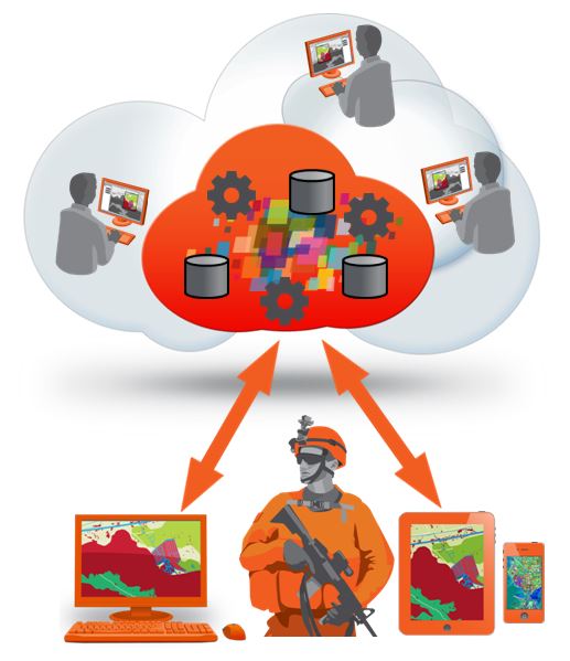
There are a large number of benefits that can be realized from this type of implementation. These include the ability for geographically dispersed analysts to share knowledge and collaborate to solve problems. It also produces cost savings at a hardware, software, and resource level by centralizing things like data, licensing, and security. All these benefits help to identify both efficiencies and gaps within the process as a whole and allow for effective implementation of new procedures to address shortcomings and promote best practice. What does this mean over the long term? In short, it means better analysis for the forward deployed. Whether in the form of direct GEOINT deliverables, consumable apps, or simply a more informed soldier, the fact of the matter is better geospatial intelligence for defense and military means better decisions.

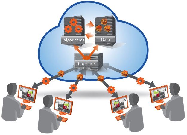
The three major, basic components of a distributed analyst network are the user interface, the data component, and the algorithm component. The user interface can be described as the program through which analysts interact with the data, algorithms, and other information available via the system. The data management component provides cataloging, search and discover, and data display capabilities to the user via the user interface, and the analysis algorithm component manages the algorithms, which are the executable analysis functions that can be run on the data in the catalog.

GEOINT Efficiences

All three of these components interact via interoperability standards in order to retrieve data and algorithms, run analyses, display results, provide notifications of newly ingested data, products or algorithms, as well as track user behavior for efficiencies and best practice.

From increased collaboration among the workforce to reduced costs to the organization, to increased efficiencies and better decision making, the benefits of implementing a shared analysis environment across a dispersed network can’t be ignored. The combined expertise of a group far outweighs the effectiveness of a single asset, and in the end, the goal of all of this is to provide more accurate, relevant information to those who need it in time for meaningful action.


What are your thoughts? Do you think the benefits of shared analysis networks outweighs the potential time and resources to switch to this type of implementation?

6 comments on article "Increase GEOINT Productivity Using Shared Image Analysis Workflows"

Avatar image

essay uk

GEOINT productivity is becoming more and more popular all over the world.There are many types of opinions for the improvement of this community.The different people have different opinions behind of this business strategy.


Avatar image

alex

Are you finding it tough to write your academic assignment? Dont waste much time! Try our assignment writing service and get your assignment written from qualified writers.

Assignment Help


Avatar image

alex

Are you finding it tough to write your academic assignment? Dont waste much time! Try our assignment writing service and get your assignment written from qualified writers. https://www.allassignmenthelp.co.uk


Avatar image

Muksh

It now really help to control and make better decisions. great post.

Kudos!

http://lovespanishpassionworld.tumblr.com/

database sql books


Avatar image

belli jons

With surety, our customer care solves problems of Microsoft windows through windows support number. So please call us on toll-free number+1-800-805-7863.

http://www.msofficesupportnumber.com/microsoft-windows-support.html

Please login or register to post comments.