X

NV5 Geospatial Blog

Each month, NV5 Geospatial posts new blog content across a variety of categories. Browse our latest posts below to learn about important geospatial information or use the search bar to find a specific topic or author. Stay informed of the latest blog posts, events, and technologies by joining our email list!


Comparing Amplitude and Coherence Time Series With ICEYE US GTR Data and ENVI SARscape

Comparing Amplitude and Coherence Time Series With ICEYE US GTR Data and ENVI SARscape

12/3/2025

Large commercial SAR satellite constellations have opened a new era for persistent Earth monitoring, giving analysts the ability to move beyond simple two-image comparisons into robust time series analysis. By acquiring SAR data with near-identical geometry every 24 hours, Ground Track Repeat (GTR) missions minimize geometric decorrelation,... Read More >

Empowering D&I Analysts to Maximize the Value of SAR

Empowering D&I Analysts to Maximize the Value of SAR

12/1/2025

Defense and intelligence (D&I) analysts rely on high-resolution imagery with frequent revisit times to effectively monitor operational areas. While optical imagery is valuable, it faces limitations from cloud cover, smoke, and in some cases, infrequent revisit times. These challenges can hinder timely and accurate data collection and... Read More >

Easily Share Workflows With the Analytics Repository

Easily Share Workflows With the Analytics Repository

10/27/2025

With the recent release of ENVI® 6.2 and the Analytics Repository, it’s now easier than ever to create and share image processing workflows across your organization. With that in mind, we wrote this blog to: Introduce the Analytics Repository Describe how you can use ENVI’s interactive workflows to... Read More >

Deploy, Share, Repeat: AI Meets the Analytics Repository

Deploy, Share, Repeat: AI Meets the Analytics Repository

10/13/2025

The upcoming release of ENVI® Deep Learning 4.0 makes it easier than ever to import, deploy, and share AI models, including industry-standard ONNX models, using the integrated Analytics Repository. Whether you're building deep learning models in PyTorch, TensorFlow, or using ENVI’s native model creation tools, ENVI... Read More >

Blazing a trail: SaraniaSat-led Team Shapes the Future of Space-Based Analytics

Blazing a trail: SaraniaSat-led Team Shapes the Future of Space-Based Analytics

10/13/2025

On July 24, 2025, a unique international partnership of SaraniaSat, NV5 Geospatial Software, BruhnBruhn Innovation (BBI), Netnod, and Hewlett Packard Enterprise (HPE) achieved something unprecedented: a true demonstration of cloud-native computing onboard the International Space Station (ISS) (Fig. 1). Figure 1. Hewlett... Read More >

1345678910Last
12789 Rate this article:
No rating

Just an analyst looking at the world

Anonym

In most cases as a geospatial analyst I use ENVI and IDL to look at the world in a rather flat and two dimensional aspect when it comes to data analytics. However, LiDAR, drones, advancements in photogrammetry, and temporal analytics within ENVI have given me the ability to analyze data in new ways that were previously too time consuming, difficult, or simply not available.

I can use tools like the photogrammetry suite to create dense point clouds over areas that it would be difficult to attain the same fidelity, or even fly over with airborne platforms. As small satellites come online they will give us coverage and revisit times unlike anything we’ve had before!

What will we do with all that data?

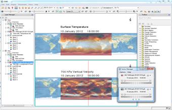
Utilizing the spatiotemporal tools in ENVI, we can gain information from days, weeks, months, or years’ worth of collects that classic change detection analytics would not support.

    Point cloud drone collectTemporal analysis            


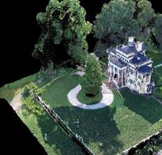
LiDAR data has become more available for analyst, and we need to be able to exploit it beyond looking at a bunch of points. Using the ENVI LiDAR tools, you can quickly and easily build robust elevation models to be used for everything from creating an ortho-mosaic to a line-of-sight analysis. We can also extract 3D models for modeling and simulation, or building scenes for decision making.


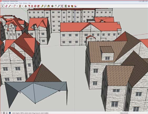
Collada models from ENVI LiDAR


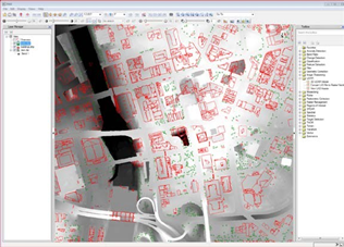
DSM and building vectors from LiDAR point cloud


I can also take advantage of IDL to build out custom tools that enable me to become a more efficient analyst. For example, I can create a tool to ingest a point cloud that gives me multiple products, where before I would have needed to create them individually. I also won’t have to rewrite my code over again when I’m ready to move to the enterprise thanks to the new ENVI task system.

Custom tool combing multiple task


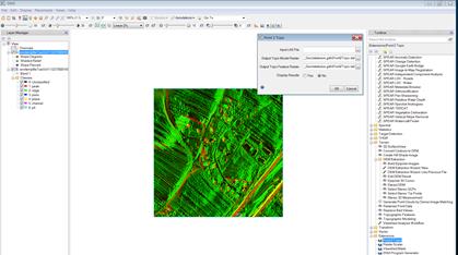
ENVI is not only allowing analyst to respond to various problem sets more efficiently, but also to ENVI enables analysts to do things that just weren’t possible a few years ago. Though the exploitation and types of data is forever changing at a rapid pace, ENVI is leading the charge to remain an industry standard for analytics.

Please login or register to post comments.