X

NV5 Geospatial Blog

Each month, NV5 Geospatial posts new blog content across a variety of categories. Browse our latest posts below to learn about important geospatial information or use the search bar to find a specific topic or author. Stay informed of the latest blog posts, events, and technologies by joining our email list!


Monitor, Measure & Mitigate: Integrated Solutions for Geohazard Risk

Monitor, Measure & Mitigate: Integrated Solutions for Geohazard Risk

9/8/2025

Geohazards such as slope instability, erosion, settlement, or seepage pose ongoing risks to critical infrastructure. Roads, railways, pipelines, and utility corridors are especially vulnerable to these natural and human-influenced processes, which can evolve silently until sudden failure occurs. Traditional ground surveys provide only periodic... Read More >

Geo Sessions 2025: Geospatial Vision Beyond the Map

Geo Sessions 2025: Geospatial Vision Beyond the Map

8/5/2025

Lidar, SAR, and Spectral: Geospatial Innovation on the Horizon Last year, Geo Sessions brought together over 5,300 registrants from 159 countries, with attendees representing education, government agencies, consulting, and top geospatial companies like Esri, NOAA, Airbus, Planet, and USGS. At this year's Geo Sessions, NV5 is... Read More >

Not All Supernovae Are Created Equal: Rethinking the Universe’s Measuring Tools

Not All Supernovae Are Created Equal: Rethinking the Universe’s Measuring Tools

6/3/2025

Rethinking the Reliability of Type 1a Supernovae   How do astronomers measure the universe? It all starts with distance. From gauging the size of a galaxy to calculating how fast the universe is expanding, measuring cosmic distances is essential to understanding everything in the sky. For nearby stars, astronomers use... Read More >

Using LLMs To Research Remote Sensing Software: Helpful, but Incomplete

Using LLMs To Research Remote Sensing Software: Helpful, but Incomplete

5/26/2025

Whether you’re new to remote sensing or a seasoned expert, there is no doubt that large language models (LLMs) like OpenAI’s ChatGPT or Google’s Gemini can be incredibly useful in many aspects of research. From exploring the electromagnetic spectrum to creating object detection models using the latest deep learning... Read More >

From Image to Insight: How GEOINT Automation Is Changing the Speed of Decision-Making

From Image to Insight: How GEOINT Automation Is Changing the Speed of Decision-Making

4/28/2025

When every second counts, the ability to process geospatial data rapidly and accurately isn’t just helpful, it’s critical. Geospatial Intelligence (GEOINT) has always played a pivotal role in defense, security, and disaster response. But in high-tempo operations, traditional workflows are no longer fast enough. Analysts are... Read More >

1345678910Last
«September 2025»
SunMonTueWedThuFriSat
31123456
78910111213
14151617181920
21222324252627
2829301234
567891011
11559 Rate this article:
5.0

Exploiting the New SWIR Bands of WV-3

Anonym

I’ve recently been fortunate to have the opportunity to explore the new SWIR bands of Worldview-3 imagery (from Digital Globe). One of the most useful features of working with the SWIR bands is that many minerals have a unique spectral response at the strategically placed wavelengths of the sensor. When treated properly, Worldview-3 SWIR data make material identification at high spatial resolution a new reality.  

There are several analytics outside the typical multispectral data analysis toolbox that are useful when working with SWIR bands. One of these that might not immediately come to mind is the minimum noise fraction (MNF) transform. Typically the MNF transform is used to separate noise from signal when working with hyperspectral data. However, it is also a great tool to derive bands that have highly unique and spatially coherent information. Take a look at the example below:


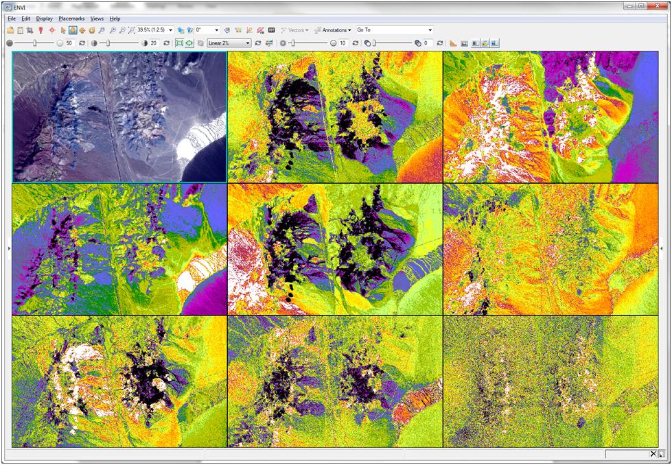
Figure 1: Worldview-3SWIR imagery – Cuprite, NV courtesy of Digital Globe. Upper left false color composite of SWIR bands 5,6, and 8 (2165, 2205, and 2330nm respectively). Next 8 images from left to right and top to bottom are MNF bands 1-8. Radiometric calibration and atmospheric correction were performed prior to MNF transform.

As you can see in each of the MNF bands, various materials become spatially coherent in each band. Because of this, MNF transforms are very useful when end member collection is an important part of the classification process. Take care to not exclude bands – even noisy ones – when you are trying to extract a material that is not abundant in the image – it might be spatially coherent in a band that otherwise contains mostly noise. From here, you might use additional tools like the pixel purity index to identify end members in the scene for use as input to supervised classification algorithms. Or alternatively, use sequential Maximum Angle Convex Come (SMACC) to derive end members and their abundance prior to classification.

While end member selection and supervised classification are excellent analytics for material identification from SWIR wavelengths, an additional technique to explore is to use spectral indices. Mathematical relationships between bands can be exploited to characterize what’s in a scene. One quick example is using the same scene above as input is to calculate the Clay MineralRatio. There are hundreds of published spectral indices out there.  As I continue to become more familiar with these new data products I’ll be sure to let you know what Idiscover. Please do the same!


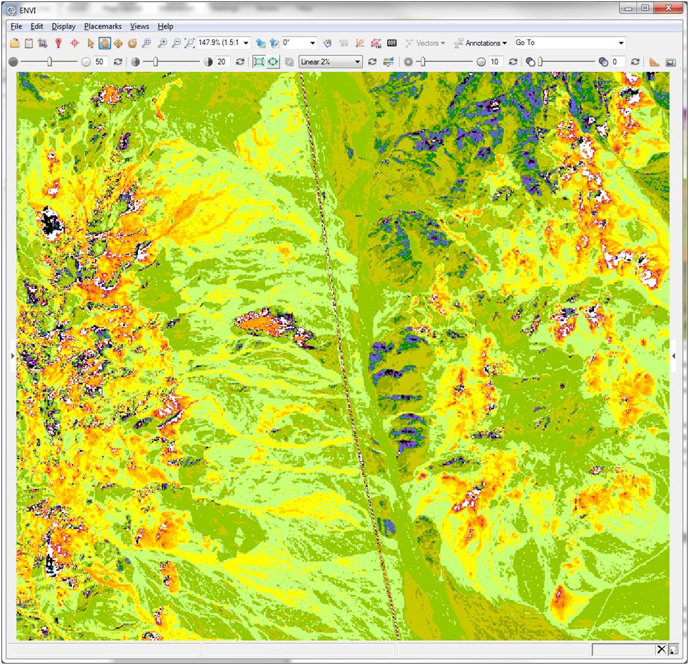
Figure 2: Clay MineralRatio with Rainbow 18 color table applied.


Take a deep dive into the MNF transform and learn more about DigitalGlobe SWIR imagery.

Please login or register to post comments.