LiDAR for Multidimensional Situational Awareness
Anonym
When using visual data to make critical decisions, it is increasingly important to understand an area of interest from all angles. In addition to the information inherent to traditional geospatial imagery, people charged to solve complex spatial problems use three-dimensional data, like LiDAR, to add meaningful content to their geospatial analysis workflows.
LiDAR, an acronym for “Light Detection and Ranging,” is an increasingly available data type that assists geospatial professionals in the derivation of various geospatial products and advanced analysis solutions, such as extracting 3D features and generating elevation maps. LiDAR technology is based on using a laser instrument to transmit an energy pulse toward a target and measure the amount of energy that is scattered back to the receiver, as well as the time taken for the pulse to return. These pulse return measurements—often comprised by millions of data points, are organized into a point cloud data set and typically delivered in the LiDAR .las data file format, as defined by the American Society of Photogrammetry and Remote Sensing (ASPRS). The behavioral interpretation of these energy pulses allows for the precise measurement of shape, geometry, and geographical position for targets in three dimensions (x, y, z) from a remote location.
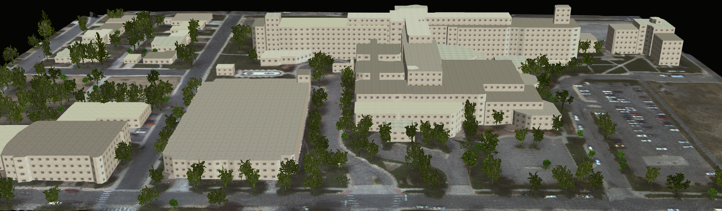
3D representation of an urban environment in Denver, CO. LiDAR data courtesy of Ball Aerospace.
The number of LiDAR sensors creating these point cloud data sets has steadily increased over the last decade. While users across many different industries and applications are seeing the advantages of using LiDAR data, the data sets are extremely large, and requires specialized software for full data exploitation. LiDAR processing software is advancing rapidly to provide interactive and automated geospatial environments that transform geo-referenced LiDAR point clouds into Geographic Information System (GIS) layers and three-dimensional models such as bare earth surfaces, digital surface models (DSM), and vectors representing buildings, trees, and utility lines.
The products and visualizations created from LiDAR data are important to a wide variety of communities and industries in both the public and private sectors. In particular, decision makers in the dynamic and time-critical environments of defense, intelligence, and emergency response sectors rely on three-dimensional reconstructions of features on the ground and precise elevations models to quickly and accurately understand the characteristics of an area and identify logistical and safety challenges. For these applications, LiDAR data and tools—particularly when used in conjunction with additional sources of geospatial data and analysis—are an important means to the rapid acquisition of comprehensive situation awareness.
The world around us is not flat; information pertinent to situational awareness and to support mission-critical decisions may not solely reside in two-dimensional imagery and data. When one analyzes the world in all three dimensions, one discovers the full potential of their available data and is able to make better, more informed decisions. With LiDAR data and advanced LiDAR processing tools, one gains the ability to quickly and accurately conduct more meaningful geospatial analysis and create a more comprehensive understanding of the world around them.