WorldView-3 & ENVI 5.2 Will Be A Powerful Combination
Anonym
Based on what I've heard thus far, it sounds like yesterday's launch of WorldView-3 was successful and we at NV5 (formerly Exelis) are extremely excited for a wide variety of reasons. First and foremost, NV5 Geospatial Software in Rochester, NY designed and built the imaging system including the panchromatic, visible-near infrared (VNIR) and short-wave infrared (SWIR) multispectral sensor systems. An excellent blog post entitled "WorldView-3: An evolution of the satellites coming before it" published just last week provides an excellent summary. Furthermore, NV5 has been working diligently on the upcoming ENVI 5.2 version of our image processing software scheduled for release fall 2014. This timing is perfect as we have developed a number of new tools and processing capabilities with WorldView-3 in mind that will be available to ENVI users right around the time WV-3 data becomes available.
There are numerous properties of the WorldView-3 commercial imaging satellite platform that will broaden applications of the data into new civil, national security and military applications including land use mapping, disaster response, mineral exploration, vegetation monitoring, coastal analysis and water resource management (just to name a few). Many of the analytical capabilities that already exist in the ENVI software today will be a perfect fit for WorldView-3 data including image classification, change detection, target detection, feature extraction and our rich suite of advanced spectral processing tools. However, what I want to highlight in this blog post is a nice alignment between WorldView-3 capabilities and some of the new feature functionality coming soon in ENVI 5.2. To be specific, there are four aspects of WorldView-3 that we find particularly exciting:
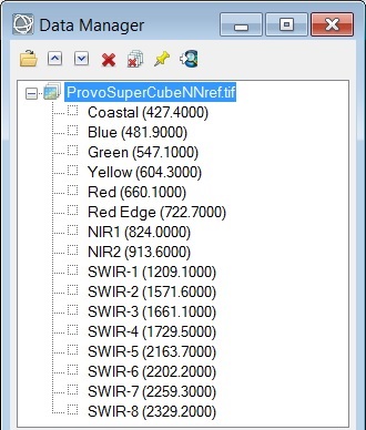
(1) Product Options: Data will be distributed in four product flavors as 4-band Pan-Sharpened, 8-band VNIR, 8-band SWIR and 16-band "SuperCube" datasets.
(2) Collection Capacity: An average revisit time of less than 1 day and ability to collect 680,000 square km per day.
(3) Spatial Resolution: A ground sample distance (GSD) of 0.31 meter panchromatic and 1.24 meter VNIR multispectral coupled with the recent relaxation on satellite imagery spatial resolution restrictions.
(4) Spectral Resolution: The addition of eight SWIR bands in the short-wave infrared range (1195nm-2365nm) focusing on specific wavelengths that pass easily through substances such as CO2 and water vapor.
So what is the new functionality in ENVI 5.2 that will be able to take advantage of WorldView-3?
(1) Product Options: First and foremost, we have been working directly with DigitalGlobe to obtain simulated sample datasets and other sensor information so we will have full support for the four WorldView-3 data products in the ENVI 5.2 software. By "full support" I mean we not only open the NITF or TIFF format file to access the image data but we also automatically assign a wide variety of useful metadata including band names, acquisition time, band center wavelengths, relative spectral response (RSR) filter functions, radiometric calibration coefficients, etc. that are used by the processing tools in ENVI.
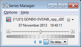
(2) Collection Capacity: You may have noticed "acquisition time" listed in the metadata we now automatically assign to raster datasets and ENVI 5.2 will be fully "time-aware" with a rich suite of capabilities for spatio-temporal analysis. This includes the ability to construct a stack of time-enabled rasters, perform radiometric corrections, normalize to a common spatial grid, visualize with a time slider+wheel control to animate the raster series, and export these animations to common video formats. With the frequent revisit period of WorldView-3 this will provide a whole host of opportunities to better understand (and predict) Earth surface processes or activities over space and time.
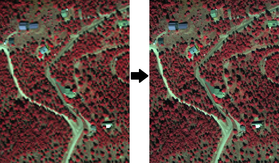
(3) Spatial Resolution: The increased spatial resolution of WorldView-3 will certainly be beneficial in projects that involve pan-sharpening and ENVI 5.2 will be introducing the new NNDiffuse image fusion algorithm developed at Rochester Institute of Technology (RIT) Digital Imaging and Remote Sensing (DIRS) Laboratory. NNDiffuse will be available as both a GUI tool in the ENVI5 desktop application and the API for batch processing and ENVI Services Engine for server deployments. The key benefits of NNDiffuse is excellent output image quality with preservation of color and spectral fidelity along with a multi-threaded implementation that provides high performance processing. Of course we don't have any real WorldView-3 data at this time but below is a preview of a NNDiffuse pan-sharpening result from a WorldView-2 dataset (data provided courtesy of DigitalGlobe):
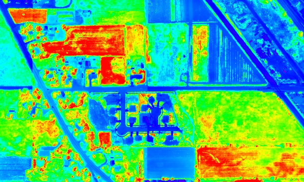
(4) Spectral Resolution: The addition of the eight short-wave infrared bands represents the first time SWIR has been available on a commercial satellite which will open up numerous analytical possibilities. One such spectral processing technique is the computation of spectral indices where band ratios using two or more spectral bands are used to accentuate the spectral differences between materials. Spectral indices provide a way to analyze materials in a manner that is not impacted by illumination or shadows and they have been used extensively in mineral exploration and vegetation mapping. ENVI 5.2 introduces a new GUI tool and associated API for batch processing that provides the ability to compute 64 spectral indices from multispectral and hyperspectral datasets. The exact number of indices that can be computed for a given input raster is based on its wavelength metadata and for WorldView-3 datasets you will be able to extract 44 different spectral indices (exact list in attached "wv3_envi_5.2_spectral_indices.txt" which also happens to illustrate API usage). For example, below is a screenshot of the Soil Adjusted Vegetation Index (SAVI) for one of the sample simulated WV-3 datasets (data provided courtesy of DigitalGlobe):