X

NV5 Geospatial Blog

Each month, NV5 Geospatial posts new blog content across a variety of categories. Browse our latest posts below to learn about important geospatial information or use the search bar to find a specific topic or author. Stay informed of the latest blog posts, events, and technologies by joining our email list!


New ENVI Agent and IDL Agent Quick Guides

New ENVI Agent and IDL Agent Quick Guides

6/1/2026

The recent release of ENVI® Agent and IDL® Agent revolutionizes how users interact with the software. These agentic AI applications act as partners to plan, simplify, and execute complex workflows. Knowing where to start can be challenging for new users. To this end, we developed two new quick guides to help you get... Read More >

Monitoring Illegal Mining in the Amazon: Turning Persistent Data Into Actionable Insight

Monitoring Illegal Mining in the Amazon: Turning Persistent Data Into Actionable Insight

5/28/2026

Illegal mining over decades has constituted one of the most persistent and complex socio-environmental problems in the Brazilian Amazon. In recent years, with the increasingly intensive use of mechanized extraction, the associated environmental impacts—such as deforestation, intense soil disturbance, river siltation, and mercury... Read More >

From Answers to Action: Why ENVI and IDL Agents Go Beyond General AI

From Answers to Action: Why ENVI and IDL Agents Go Beyond General AI

4/20/2026

As generative AI tools like Claude and Gemini continue to gain traction, many organizations are asking the same question: Can general purpose AI actually support real geospatial workflows, or does it stop at surface-level answers? That question was front and center in our recent webinar, Meet Your New Partners in Science: ENVI... Read More >

Mapping Earthquake Deformation in Taiwan With ENVI

Mapping Earthquake Deformation in Taiwan With ENVI

12/15/2025

Unlocking Critical Insights With ENVI® Tools Taiwan sits at the junction of major tectonic plates and regularly experiences powerful earthquakes. Understanding how the ground moves during these events is essential for disaster preparedness, public safety, and building community resilience. But traditional approaches like field... Read More >

Comparing Amplitude and Coherence Time Series With ICEYE US GTR Data and ENVI SARscape

Comparing Amplitude and Coherence Time Series With ICEYE US GTR Data and ENVI SARscape

12/3/2025

Large commercial SAR satellite constellations have opened a new era for persistent Earth monitoring, giving analysts the ability to move beyond simple two-image comparisons into robust time series analysis. By acquiring SAR data with near-identical geometry every 24 hours, Ground Track Repeat (GTR) missions minimize geometric decorrelation,... Read More >

1345678910Last
«June 2026»
SunMonTueWedThuFriSat
31123456
78910111213
14151617181920
21222324252627
2829301234
567891011
24536 Rate this article:
No rating

Looking Back on Mount St. Helens Through the Lens of Landsat Imagery

Anonym

It was with a bit of a thrill that I recently stumbled across these images of Mount St. Helens from 1984 and 2013 at NASA's Earth Observatory site. I grew up in southeastern Washington state, and was 15 years old when Mount St. Helens blew in 1980. I remember noticing the unusual clouds while leaving church with my family that Sunday morning. As we chatted with friends,we eventually realized that something odd was falling from those clouds, and we'd better turn on the news and figure out what was going on. My town didn't get the worst of the ash fall, but schools and businesses closed for days as the ash gently accumulated. A few days after the eruption, I remember sitting on a park bench with my best friend, astonished by how the red of the strawberries we shared seemed to glow in contrast to the ash-gray landscape.

Landsat 5 Mount St. Helens
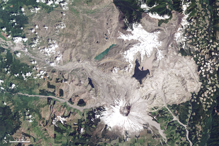
True color Landsat 5 Thematic Mapper image of Mount St. Helens acquired June 17, 1984. Image courtesy of NASA.

Not much life in the area immediately surrounding the mountain survived that eruption. But it didn't take long for it to return. I hiked Mount St. Helens in 1985, five years later. The abundant pink fireweed was eerily beautiful against the ash that surrounded the visitor center.

I visited Mount St. Helens again about 15 years later, and I could barely recognize the landscape. Our wooded campground was in an area that had been devoid of trees in my earlier visit. The visitor center - while still providing an impressive view of the crater - was now surrounded by vegetation and wildlife. It was hard to fully appreciate the devastation that I'd witnessed myself in 1985.

Landsat 8 Mount St. Helens
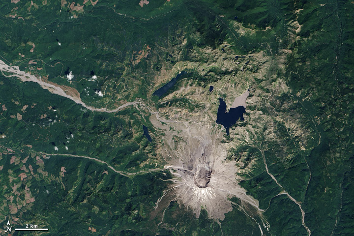
True color Landsat 8 OLI image of Mount St. Helens acquired August 21, 2013. Image courtesy of NASA.

If you ever get the chance, I highly recommend a visit to Mount St. Helens National Monument. It has one of the best visitors' centers I've ever seen. I don't know if they have an exhibit with these Landsat images,but I hope they do. As all of us who work with remotely sensed imagery know, the satellite perspective is always one of the most informative and awe-inspiring.

Please login or register to post comments.