X

NV5 Geospatial Blog

Each month, NV5 Geospatial posts new blog content across a variety of categories. Browse our latest posts below to learn about important geospatial information or use the search bar to find a specific topic or author. Stay informed of the latest blog posts, events, and technologies by joining our email list!


Comparing Amplitude and Coherence Time Series With ICEYE US GTR Data and ENVI SARscape

Comparing Amplitude and Coherence Time Series With ICEYE US GTR Data and ENVI SARscape

12/3/2025

Large commercial SAR satellite constellations have opened a new era for persistent Earth monitoring, giving analysts the ability to move beyond simple two-image comparisons into robust time series analysis. By acquiring SAR data with near-identical geometry every 24 hours, Ground Track Repeat (GTR) missions minimize geometric decorrelation,... Read More >

Empowering D&I Analysts to Maximize the Value of SAR

Empowering D&I Analysts to Maximize the Value of SAR

12/1/2025

Defense and intelligence (D&I) analysts rely on high-resolution imagery with frequent revisit times to effectively monitor operational areas. While optical imagery is valuable, it faces limitations from cloud cover, smoke, and in some cases, infrequent revisit times. These challenges can hinder timely and accurate data collection and... Read More >

Easily Share Workflows With the Analytics Repository

Easily Share Workflows With the Analytics Repository

10/27/2025

With the recent release of ENVI® 6.2 and the Analytics Repository, it’s now easier than ever to create and share image processing workflows across your organization. With that in mind, we wrote this blog to: Introduce the Analytics Repository Describe how you can use ENVI’s interactive workflows to... Read More >

Deploy, Share, Repeat: AI Meets the Analytics Repository

Deploy, Share, Repeat: AI Meets the Analytics Repository

10/13/2025

The upcoming release of ENVI® Deep Learning 4.0 makes it easier than ever to import, deploy, and share AI models, including industry-standard ONNX models, using the integrated Analytics Repository. Whether you're building deep learning models in PyTorch, TensorFlow, or using ENVI’s native model creation tools, ENVI... Read More >

Blazing a trail: SaraniaSat-led Team Shapes the Future of Space-Based Analytics

Blazing a trail: SaraniaSat-led Team Shapes the Future of Space-Based Analytics

10/13/2025

On July 24, 2025, a unique international partnership of SaraniaSat, NV5 Geospatial Software, BruhnBruhn Innovation (BBI), Netnod, and Hewlett Packard Enterprise (HPE) achieved something unprecedented: a true demonstration of cloud-native computing onboard the International Space Station (ISS) (Fig. 1). Figure 1. Hewlett... Read More >

1345678910Last
19690 Rate this article:
No rating

Moving At The Speed Of Summer

Lazy Days No More

Anonym

I was on vacation last week, visiting family and enjoying a change of scenery. When I left on the trip, it was summer here in the Northern Hemisphere. Returning on Monday, that has all changed. Basically, if you’re not ready for fall now, you’re already very far behind. Classes at CU Boulder start in 18 days, and the Parade Of U-Hauls has begun as students move back and leases expire. Another sign of the looming end of summer: the deadline for submitting an abstract to the 2014 AGU Fall Meeting (in San Francisco 15-19December) is the end of today. It was extended 24 hours due to overwhelming demand crashing their system. So, it’s not just summer that’s speeding along. In spite of meager funding and support in the US, progress in the earth sciences is rapid, too. As of this morning, AGU had already received 19,500abstracts. We’ll see if there’s a new record when the deadline passes tonight.


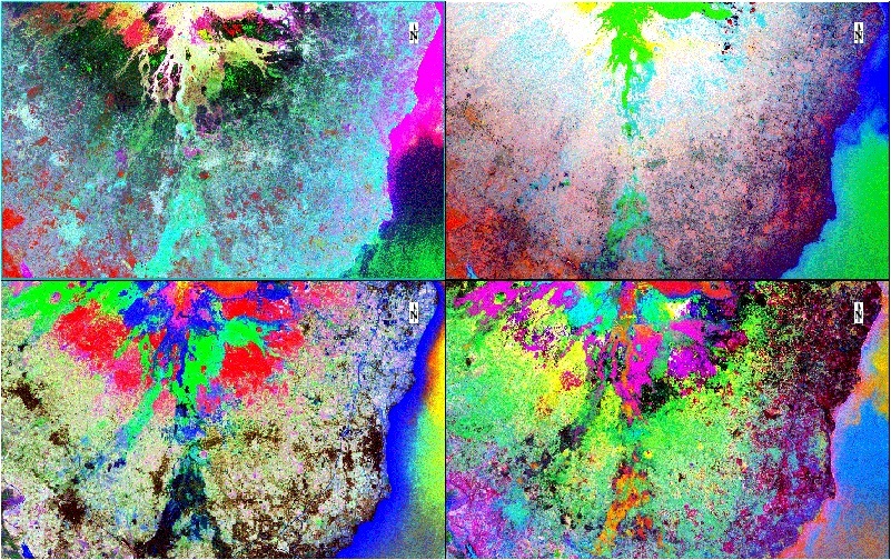
Time has an extra bit of importance compared to other variables because it has a habit of slipping away so quickly, and you can never get it back. (That was a week of vacation? Felt like two days, three tops…). It has extra significance in geospatial work because how things work and change over time is where the interesting and important results are found. Sea ice extent or current climate are interesting, but how they’re changing and why is the critical part. For #AGU14 I’m co-author with my colleague Robert Schafer on an abstract highlighting a new set of time series tools for geospatial data that will be in our new ENVI release this fall. My first-author submission, “Using Advanced Remote Sensing Data Fusion Techniques for Studying Earth Surface Processes and Hazards: A Landslide Detection Case Study”, is a case study using a new algorithm I’ve developed showing some promising results for landslide, hazards, and change detection on multi-temporal and multi-modal datasets. Vacations and summer might slip by quickly, and there’s not much we can do to stop that. But, what we can now do with geospatial data over time will at least let us make the most of it!


There is at least one instance when time moves slowly. I’ll have to wait until October to find out if I’ll be giving a talk or a poster at the Fall Meeting. Have you submitted an abstract? I hope to see you there! Until then, here’s a sneak preview of that algorithm’s results, run on some Landsat 8data over Sicily.


Please login or register to post comments.