X

NV5 Geospatial Blog

Each month, NV5 Geospatial posts new blog content across a variety of categories. Browse our latest posts below to learn about important geospatial information or use the search bar to find a specific topic or author. Stay informed of the latest blog posts, events, and technologies by joining our email list!


From Image to Insight: How GEOINT Automation Is Changing the Speed of Decision-Making

From Image to Insight: How GEOINT Automation Is Changing the Speed of Decision-Making

4/28/2025

When every second counts, the ability to process geospatial data rapidly and accurately isn’t just helpful, it’s critical. Geospatial Intelligence (GEOINT) has always played a pivotal role in defense, security, and disaster response. But in high-tempo operations, traditional workflows are no longer fast enough. Analysts are... Read More >

Thermal Infrared Echoes: Illuminating the Last Gasp of a Dying Star

Thermal Infrared Echoes: Illuminating the Last Gasp of a Dying Star

4/24/2025

This blog was written by Eli Dwek, Emeritus, NASA Goddard Space Flight Center, Greenbelt, MD and Research Fellow, Center for Astrophysics, Harvard & Smithsonian, Cambridge, MA. It is the fifth blog in a series showcasing our IDL® Fellows program which supports passionate retired IDL users who may need support to continue their work... Read More >

A New Era of Hyperspectral Imaging with ENVI® and Wyvern’s Open Data Program

A New Era of Hyperspectral Imaging with ENVI® and Wyvern’s Open Data Program

2/25/2025

This blog was written in collaboration with Adam O’Connor from Wyvern.   As hyperspectral imaging (HSI) continues to grow in importance, access to high-quality satellite data is key to unlocking new insights in environmental monitoring, agriculture, forestry, mining, security, energy infrastructure management, and more.... Read More >

Ensure Mission Success With the Deployable Tactical Analytics Kit (DTAK)

Ensure Mission Success With the Deployable Tactical Analytics Kit (DTAK)

2/11/2025

In today’s fast-evolving world, operational success hinges on real-time geospatial intelligence and data-driven decisions. Whether it’s responding to natural disasters, securing borders, or executing military operations, having the right tools to integrate and analyze data can mean the difference between success and failure.... Read More >

How the COVID-19 Lockdown Improved Air Quality in Ecuador: A Deep Dive Using Satellite Data and ENVI® Software

How the COVID-19 Lockdown Improved Air Quality in Ecuador: A Deep Dive Using Satellite Data and ENVI® Software

1/21/2025

The COVID-19 pandemic drastically altered daily life, leading to unexpected environmental changes, particularly in air quality. Ecuador, like many other countries, experienced significant shifts in pollutant concentrations due to lockdown measures. In collaboration with Geospace Solutions and Universidad de las Fuerzas Armadas ESPE,... Read More >

1345678910Last
«May 2025»
SunMonTueWedThuFriSat
27282930123
45678910
11121314151617
18192021222324
25262728293031
1234567
12274 Rate this article:
No rating

Plain as Day

Anonym

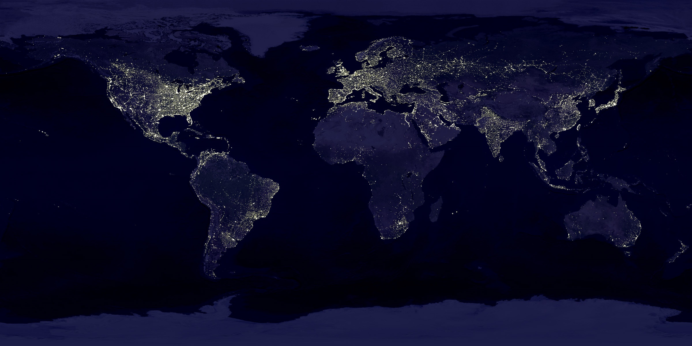
Or in this case would it be plain as night?

I recently read an article in the New York Times about the “wonderment” a Harvard Economics professor discovered in the global night lights data that is freely available from NASA. The professor, Dr. Sendhill Mullainathan, was gushing about the insights this data provided for global analysis of poverty. Essentially what his analysis came down to was this: No lights, no money.

Having spent the last 30-plus years as a remote sensing scientist I thought: “Really? You didn’t know that?” And I did have moment of feeling rather smug that a Harvard Professor had just “discovered” something that to me was obvious.  

But then I too had an "ah ha!" moment when I stepped back to see the data from this very different perspective. From new ideas spring new services. In this case it would be a global change analysis service using night-lights data at scale. A thousand more of these types of use cases and we can scale-out the type of consumer driven market we all want in this business

And here's the point of this blog. Dr. Mullainathan, and others of his ilk, are exactly the types of people we want to consume geospatial analytics so they can bring their insights, economics in this case, as new ideas into the market. Because while at first his "realization" seemed very rudimentary to me, once I was able to zoom out, I realized it was not a bad idea at all, this night lights stuff.

Too bad the experts like me don't always see what is right under our noses.

Please login or register to post comments.