The Future of Weather Observation is Coming Soon! GOES-R
Anonym
If all goes according
to plan, next month the GOES-R weather satellite will be launching and the next generation of weather forecasting, solar activity monitoring, and lightening detection will be here. This advanced satellite will change how quickly and accurately we are able to monitor and
predict hazardous weather and help give those in harm’s way the time needed to
prepare and evacuate. The GOES-R satellite will include:
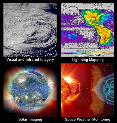
Advanced Baseline Imager (ABI) – an advanced imager that has 3 times
more channels, 4 times better resolution , and 5 times faster than before. All of
this leads to better observation of severe storms, fire, smoke,
aerosols, and volcanic ash.
Geostationary Lightening Mapper - The lightning mapper will allow
mapping of lightning strikes on ground, as well as lightning in the atmosphere.
Researchers have found that an increase in lightning activity may be a sign of
tornadoes forming, thus providing the data to detect tornadoes faster.
Space Weather Observation - GOES-R will work with NOAA
instruments to gather information on radiation hazards from sun that can
interfere with communication and navigation systems, damage satellites,
threaten power utilities.
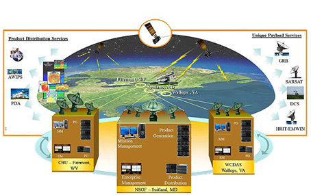
Harris
Corporation has been supporting NOAA with some aspects on the GOES-R Satellite
construction and will be providing the Ground System Support, as well as the
16.4 Meter triband antenna needed to stay in touch with it.
Now what
does this have to do with ENVI? Once GOES-R is operational and collecting data,
ENVI will be working to support the Harris Weather groups WXconnect systems for
data validation and visualization, supporting the ABI data directly in ENVI, as
well as working with NOAA to help continue to create advanced products in the
future. It is an exciting time for NOAA with this milestone launch and an
exciting time to be working with ENVI to get to work the advanced data that
will be coming down!
Below are the baseline products, as
well as some future products that can be expected.
|
BASELINE PRODUCTS
|
FUTURE PRODUCTS
|
|
Advanced Baseline Imager (ABI)
|
Absorbed Shortwave Radiation: Surface
|
|
Aerosol Detection (Including Smoke and Dust)
|
Aerosol Particle Size
|
|
Aerosol Optical Depth (AOD)
|
Aircraft Icing Threat
|
|
Clear Sky Masks
|
Cloud Ice Water Path
|
|
Cloud and Moisture Imagery
|
Cloud Layers/Heights
|
|
Cloud Optical Depth
|
Cloud Liquid Water
|
|
Cloud Particle Size Distribution
|
Cloud Type
|
|
Cloud Top Height
|
Convective Initiation
|
|
Cloud Top Phase
|
Currents
|
|
Cloud Top Pressure
|
Currents: Offshore
|
|
Cloud Top Temperature
|
Downward Longwave Radiation: Surface
|
|
Derived Motion Winds
|
Enhanced "V" / Overshooting Top Detection
|
|
Derived Stability Indices
|
Flood/Standing Water
|
|
Downward Shortwave Radiation: Surface
|
Ice Cover
|
|
Fire/Hot Spot Characterization
|
Low Cloud and Fog
|
|
Hurricane Intensity Estimation
|
Ozone Total
|
|
Land Surface Temperature (Skin)
|
Probability of Rainfall
|
|
Legacy Vertical Moisture Profile
|
Rainfall Potential
|
|
Legacy Vertical Temperature Profile
|
Sea and Lake Ice: Age
|
|
Radiances
|
Sea and Lake Ice: Concentration
|
|
Rainfall Rate / QPE
|
Sea and Lake Ice: Motion
|
|
Reflected Shortwave Radiation: TOA
|
Snow Depth (Over Plains)
|
|
Sea Surface Temperature (Skin)
|
SO2 Detection
|
|
Snow Cover
|
Surface Albedo
|
|
Total Precipitable Water
|
Surface Emissivity
|
|
Volcanic Ash: Detection and Height
|
Tropopause Folding Turbulence Prediction
|
|
Geostationary Lightning Mapper (GLM)
|
Upward Longwave Radiation: Surface
|
|
Lightning Detection: Events, Groups & Flashes
|
Upward Longwave Radiation: TOA
|
|
Space Environment In-Situ Suite (SEISS)
|
Vegetation Fraction: Green
|
|
Energetic Heavy Ions
|
Vegetation Index
|
|
Magnetospheric Electrons & Protons: Low Energy
|
Visibility
|
|
Magnetospheric Electrons & Protons: Med & High Energy
|
|
|
Solar & Galactic Protons
|
|
|
Magnetometer (MAG)
|
|
|
Geomagnetic Field
|
|
|
Extreme Ultraviolet and X-ray Irradiance Suite (EXIS)
|
|
|
Solar Flux: EUV
|
|
|
Solar Flux: X-ray Irradiance
|
|
|
Solar Ultraviolet Imager (SUVI)
|
|
|
Solar EUV Imagery
|
|