UAV’s as a Remote Sensing Platform for Agriculture
Anonym
Over the last couple of years, we have seen news about UAVs and their utility in commercial and civil markets. I have a particularly strong interest in UAV technology that reaches back to my days as an Electrical Engineering student designing a hovercraft resembling a quad copter, controlled via a software application providing aircraft position and other telemetry back to the pilot. Adding to this industry interest is that one of the FAA’s test sites is nearly in my backyard, Griffiss International Airport Unmanned Aircraft Systems (UAS) in Rome, N.Y. Furthermore, in early August 2014, the FAA approved the Northeast UAS Airspace Integration Research (NUAIR) and Griffiss International Airport’s first official Certificate of Authorization (COA) to test unmanned aircraft. This first COA allows operation of unmanned aerial system for agriculture led by Cornell Cooperative Extension (CCE). CCE has provided tremendous benefits to our local agricultural industry and I am pleased to see that they are getting this effort started.
CCE will fly a UAS manufactured by Precision Hawk. Precision Hawk’s Lancaster Hawkeye Mk III, a small fixed-wing aircraft, will carry visual, thermal and multi-spectral sensors. The UAS will fly below 400 feet over farms in western New York evaluating field crops such as corn, soybean, wheat and alfalfa. The collected data will be used to monitor crop growth, insect activity, disease spread, soil conditions and more.
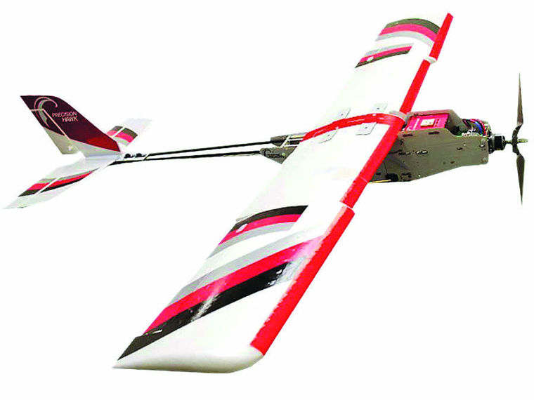
Photo courtesy of Finger Lakes Times a Precision Hawk Lancaster Hawkeye Mk IIIUAV
Precision farmers today use aerial and satellite remote sensing imagery to help them more efficiently manage their crops. By measuring precisely the way their fields reflect and emit energy at visible and infrared wavelengths, precision farmers can monitor a wide range of variables that affect their crops. Multi-spectral and thermal sensors allow farmers to view problems that were not possible with the naked eye or with panchromatic aerial imagery.
Precision Hawk’s sensors will be collecting data at the necessary wavelengths required to extract meaningful information to answer questions such as “what is the health of my crop”. Using a UAV as the platform for remote sensing still requires remote sensing practices to provide the most accurate answers to grower’s questions. A fellow colleague identified a best practices approach to ensure generation of output products of the highest quality to solve a problem at hand. The best practices approach is: (1) identify the algorithm needed to solve the problem, (2) determine the wavelength input for the algorithm, (3) establish what sensor(s) can collect those wavelengths, and (4) decide the platform equipped to fly the payload.
The best practices were recently applied comparing normalized difference vegetation index (NDVI) products using raw sensor data from a UAS payload, and data that were corrected after applying calibration to each band in the image. NDVI is a common benchmark for determining vegetative health.
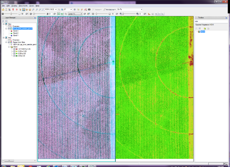
Figure1: UAS image and NDVI calculated from original image prior to applying any data calibration or correction.
Referring to Figure 1(raw data)
- Total vegetation represents 95.76% of the field with dry soil or non-vegetation representing 5.24%.
- Dry vegetation (yellow) accounts for 48.73% whereas healthy and very healthy vegetation (shades of green) accounts for 46.03%.
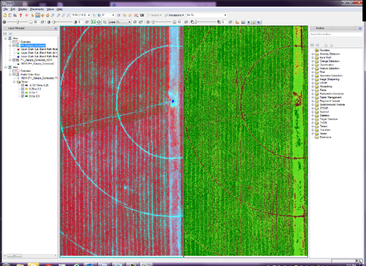
Figure 2: UAS image and NDVI calculated after applying data calibration and correction.
The results shown in Figure 2 with data calibration and correction produce a more accurate assessment.
- Total vegetation represents 87.64% of the field with dry soil or non-vegetation representing 12.36%.
- Dry vegetation (yellow) accounts for 3.47% whereas healthy and very healthy vegetation (shades of green) account for 84.18%.
The results show that to provide the grower with the most accurate information requires more than just collecting data and running that raw data through an algorithm. Using best practices such as those identified by my colleague, growers can focus on specific problems or information with different sensors and algorithms. I would imagine that as this advances, there would be automated processes that will automatically provide answers to grower’s questions.
The benefits of utilizing UAV’s in agriculture is being able to see a field in its entirety, which can be time consuming and unrealistic for farmers to do on foot. The fields can be viewed as frequently as desired and at a lower cost than utilizing a manned airborne platform or satellite imagery.
Additionally, UAV’s equipped with appropriate sensors can use the collected data in a science-based approach, enabling them to identify problems faster and execute treatment plans to prevent the spread of disease or pests that could affect an entire field. Then they can fly the fields again repeating the process within a week or two to monitor change. According to the agronomist from CCE that will be flying the Precision Hawk UAV, farmers are spending tens of thousands of dollars now on crop health: how green are the plants, as well as tracking disease and harmful insects. Efforts like CCE’s will provide insight into the benefit of UAV’s in the agricultural industry and what the true benefit to the grower is. Of course, the goal is higher crop yield resulting in higher profits. In addition, reducing crop treatment costs by targeting only areas requiring it all while reducing the negative impacts of farming on the environment that come from over-application of chemicals.
I look forward to monitoring Cornell Cooperatives Extension’s effort and will keep my eyes in the sky to see if they may be flying the vineyards around my hometown.